


Chapter 9.28
Combining Zones
Sections:
9.28.020 Applicability of Combining Zones
9.28.040 Historic Landmark (:HL) Combining Zone
9.28.050 Natural Hazards (:NH) Combining Zone
9.28.060 Neighborhood Conservation Area (:NCA) Combining Zone
9.28.070 Planned Development (:PD) Combining Zone
9.28.080 Plaza Area (:PA) Combining Zone
9.28.090 Special Considerations (:SC) Combining Zone
9.28.100 Wetland Protection (:WP) and Stream Protection (:SP) Combining Zones
9.28.110 Housing For Homeless (:HH) Combining Zone
9.28.130 Cannabis Innovation Zone (:CIZ) Combining Zone
9.28.140 Mobilehome Park (:MP) Combining Zone
9.28.010 Purpose
The provisions of this Chapter regulate development and new land uses in the combining zones established by Section 9.12.020 (Zoning Map and Zoning Districts). Combining zones are applied to property in conjunction with a primary zoning district (for example, RVL:NH on the Zoning Map would indicate that a site is designated Residential - Very Low Density (RVL), and is also within the Natural Hazards combining zone (:NH)), to note where important site, environmental, safety, compatibility, and/or design issues require particular attention in project planning and design. The combining zones provide guidance for development within the combining zones through standards that apply to proposed development in addition to the standards and regulations of the primary zoning district. (Ord. 1432, eff. 12/20/2013)
9.28.020 Applicability of Combining Zones
The provisions of this Chapter apply to proposed land uses and development in addition to all other applicable requirements of this Land Use Code. Any perceived conflict between the provisions of this Chapter and any other provision of this Land Use Code shall be resolved in compliance with Section 9.10.050 (Rules of Interpretation).
A. Mapping of combining zones. The applicability of any combining zone to a specific site is shown by the combining Zoning Map symbol established by Section 9.12.020 (Zoning Map and Zoning Districts), being appended as a suffix to the symbol for the primary zoning district on the Zoning Map. The combining zones are applied to property through the rezoning process (Chapter 9.92) or through the adopted zoning map.
B. Allowed land uses, permit requirements, development standards. Except as may be otherwise provided by this Chapter for a specific combining zone:
1. Any land use normally allowed in the primary zoning district by this Article may be allowed within a combining zone, subject to any additional requirements of the combining zone;
2. Development and new land uses within a combining zone shall obtain the approvals required by this Article for the primary zoning district; and
3. Development and new land uses within a combining zone shall comply with all applicable development standards of the primary zoning district, all other applicable provisions of this Land Use Code (e.g., Article 3 - Site Planning and Project Design Standards).
9.28.030 Coastal Zone (:CZ) Combining Zone
Repealed by Ord. 1432.
9.28.040 Historic Landmark (:HL) Combining Zone
A. Purpose. The :HL combining zone is intended to assist in the protection, enhancement, perpetuation, and use of structures that are reminders of past eras, events, and persons important in local, state, or national history, or that provide significant examples of past architectural styles, or are landmarks in the history of architecture, or that are unique and irreplaceable assets to the City and the structures in the immediate neighborhood or that provide for Arcata citizens examples of the structures in which past generations lived.
B. Applicability. The :HL combining zone is applied to property in compliance with the provisions of Chapter 9.53 (Historical Resource Preservation), and may be combined with any primary zoning district established by Section 9.12.020 (Zoning Map and Zoning Districts).
C. Land use and development standards. Proposed development and new land uses within the :HL combining zone shall comply with the requirements of Chapter 9.53, the primary zoning district, and all other applicable provisions of this Land Use Code.
9.28.050 Natural Hazards (:NH) Combining Zone
A. Purpose. The :NH combining zone provides regulations for areas subject to natural hazards, to:
1. Protect lives and property from destruction and damage, to protect the community from the costs resulting from unstable or premature development occurring in these areas;
2. Allow development that is appropriate in these areas, in compliance with Federal Emergency Management Agency (FEMA) and California Department of Water Resources regulations for flood control, and the Alquist-Priolo Earthquake Fault Zoning Act of 1972; and
3. Alert property owners, potential buyers and other interested parties that a high potential for risk exists.
The :NH combining zone is applied only in the highest risk categories.
B. Applicability. The :NH combining zone may be combined with any primary zoning district established by Section 9.12.020 (Zoning Map and Zoning Districts), and shall be combined with the primary zoning district in the following areas:
1. Earthquake hazard areas. Earthquake fault hazard areas, including:
a. The Alquist-Priolo Earthquake Fault Zone, as delineated by the Seismic Safety Element; and
b. All land within 300 feet of a Potentially Active Thrust Fault, as delineated by the Seismic Safety Element.
Proposed development and new land uses in these areas shall comply with the requirements of the Geologic Hazard Review process in Chapter 9.62 (Geologic Hazard Review).
2. Landslide Hazard Areas. Landslide hazard areas with high landslide risk, as delineated by the Seismic Safety Element. Proposed development and new land uses in these areas shall comply with the requirements of the Geologic Hazard Review process in Chapter 9.62 (Geologic Hazard Review).
3. Liquefaction Areas. Liquefaction hazard areas with high liquefaction potential, as delineated by the Seismic Safety Element. Proposed development and new land uses in these areas shall comply with the requirements of the Geologic Hazard Review process in Chapter 9.62 (Geologic Hazard Review).
C. Permit Requirements. Proposed development and new land uses shall comply with the planning permit requirements of the applicable primary zoning district, and the geologic hazard review process (Chapter 9.62, Geologic Hazard Review), and/or flood hazard review process in Title VIII, Chapter 4, as applicable.
1. Geologic or other studies may be required in addition to those otherwise required for Geologic Hazard Review or Flood Hazard Review, depending on the project proposed.
2. Site-specific reports prepared in compliance with this Section shall be considered amendments to the Seismic Safety Element maps when a conflict between the general map and a site-specific report is identified.
D. Land Use Limitations. Any land use normally allowed as a permitted or conditional use in the primary zoning district by this Article may be allowed within the :NH combining zone, subject to the requirements of this Section, except as follows.
1. Conditional Uses. The following uses may be permitted with Use Permit approval (Section 9.72.080, Use Permit and Minor Use Permit):
a. Uses that are allowed by this Article in the primary zoning district with Use Permit approval; and
b. The construction of levees, dikes or other flood structures designed to protect property from natural flood hazards. Within the Coastal Zone, these structures shall comply with the requirements of the City’s LCP.
2. Critical Facilities. Critical facilities within the :NH combining zone are limited as follows.
a. Critical Facilities Defined. For the purposes of this Section, the following are considered critical facilities:
(1) Hazardous Facilities. Hazardous substance storage reservoirs, including gasoline, natural gas, oil, industrial waste, and any other substances on the EPA list of hazardous substances.
(2) Essential Facilities. Hospitals, fire and police stations, emergency control centers, power plants, power substations, designated emergency communication facilities, schools and other similar uses that must be available to operate after an emergency.
(3) High Risk Facilities. Auditoriums, hotels, large motels, major office buildings, theaters, high density apartments, and other similar uses that accommodate large numbers of people.
b. Prohibited Areas. Critical facilities are prohibited in:
(1) The High Liquefaction Hazard Area (Category I) as shown in Seismic Safety Element; and
(2) Coastal High Hazard Areas (Tsunami), as defined in the City’s LCP.
c. Design Standards.
(1) Critical Facilities should be designed to function at peak efficiency after a magnitude 7.7 earthquake in the Mad River Fault Zone.
(2) Site specific investigations, as indicated by the Geologic Hazards Review process (Chapter 9.62), shall be required prior to the construction of Critical Facilities. If it is found that engineering techniques cannot mitigate the hazards to within acceptable risk levels appropriate to the intended land use, the location of the proposed development should be reconsidered. (Ord. 1432, eff. 12/20/2013; Ord. 1484, eff. 3/17/2017)
9.28.060 Neighborhood Conservation Area (:NCA) Combining Zone
A. Purpose. The :NCA combining zone is applied to areas identified by General Plan Policy H-4, to ensure that new construction, modifications or alterations to structures and site layouts are harmonious with existing neighborhood character, and that historical resources are protected.
B. Applicability. The :NCA combining zone may be combined with any primary zoning district established by Section 9.12.020 (Zoning Map and Zoning Districts).
C. Land Use and Development Standards. Proposed development and new land uses on a site within the :NCA combining zone shall comply with the requirements of the primary zoning district, all other applicable provisions of this Land Use Code, and the provisions of this Section.
D. Design Review Requirements. Design Review shall be required for new construction and alterations proposed within a Neighborhood Conservation Area (NCA) as identified in Land Use Code Section 9.72.040.
1. Findings Required for Approval. Design Review approval within the :NCA combining zone shall require that the review authority first find that the design of the proposed structure, alteration or addition is compatible with and does not destroy the historic or architectural character of the property and the neighborhood conservation area. (Ord. 1513, eff. 3/8/2019)
9.28.070 Planned Development (:PD) Combining Zone
A. Purpose. The :PD combining zone is intended to allow development of land as a single unit by taking advantage of modern site planning techniques to result in a more efficient use of land and a better living environment than is otherwise possible through strict application of development standards. The objective is to provide a means for project design to more effectively respond to on-site environmental resources, adjacent neighborhood character, and community needs, than a project that is possible only in compliance with the requirements of the primary zoning district.
B. Applicability. The :PD combining zone may be combined with any primary zoning district established by Section 9.12.020 (Zoning Map and Zoning Districts). The :PD combining zone may provide for exceptions to development standards, including but not limited to: site coverage; density; lot area, width and depth; ground coverage; yard; height; parking; loading; sign; and landscaping requirements of the primary zoning district applicable to the site.
C. Permit Requirements. Planned Development Permit approval in compliance with Section 9.72.070 (Planned Development Permit) shall be required for all development in a :PD combining zone.
D. Land Use and Development Standards. Proposed development within the :PD combining zone shall comply with the land use activity requirements of the primary zoning district, and all other applicable provisions of this Land Use Code, except to the extent modified by the approved Planned Development Permit, and except as follows.
1. Allowable Density. The Planning Commission may allow an increase of up to 20 percent over the amount of floor area or number of units permitted depending upon the nature of the site and design of the structures in relation to the surrounding area.
The 20 percent increase in the permitted density or floor area is in addition to any increase permitted by Chapter 9.31 (Density Bonuses).
2. Bike and pedestrian facilities. In addition to any required open space land, the project developer shall dedicate land for bicycle and pedestrian route facilities if the project is adjacent to or contains a proposed route in the adopted Pedestrian and Bicycle Master Plan or in the Transportation Element of the General Plan.
a. The developer shall dedicate land for bicycle and pedestrian route facilities which are available for the use, safety, and enjoyment of the general public. The location of the land dedicated for the bicycle and pedestrian route facilities shall generally conform to the location of the proposed route as designated in the Master Plan or in the Transportation Element. The cost of any improvements installed by the developer for the bicycle and pedestrian facility may be deducted from any park-in-lieu fee or recreation fee for new construction requirements of the development.
b. In the case of a project that is not adjacent to, or that does not contain a proposed route of an adopted system, the developer may be required to dedicate bicycle or pedestrian route facilities for the use, safety, and enjoyment of the residents of the project. The type, alignment, and location of the bicycle or pedestrian route facilities shall be appropriate to the size, character and location of the project, as determined by the Planning Commission.
c. Where practical, the bicycle and pedestrian route facilities shall provide access to a neighboring school, playground, shopping area, or other community facility, or to an adjacent street which, in the determination of the Planning Commission, is suitable for bicycle and/or pedestrian traffic.
9.28.080 Plaza Area (:PA) Combining Zone
A. Purpose. The :PA combining zone establishes special standards for the Plaza area to address its unique character, including its predominant architecture. In conjunction with the underlying CC (Commercial - Central) primary zoning, the standards of this Section are intended to encourage development or redevelopment in a manner consistent with the unique character of the Plaza, while maintaining compatibility with the remainder of the Central Business District.
B. Applicability. The :PA combining zone may be applied only to parcels adjacent to and facing the Plaza. This shall include parcels within the four half-blocks opposite the sides of the Plaza and parcels opposite the four corners of the Plaza.
C. Land use and development standards. Proposed development and new land uses within the :PA combining zone shall comply with the requirements of the primary zoning district, and all other applicable provisions of this Land Use Code, except that:
1. Within the :PA combining zone, but not within the remainder of the CC zone, a residential use may be located only in upstairs or alley-frontage locations. Ground floor, street-frontage locations shall be used only for non-residential purposes.
2. The vision clearance requirements of Section 9.30.040.E (Height limit at streets) do not apply within the :PA combining zone.
3. Any new development shall incorporate an appropriate combination of project enhancements. Potential enhancements include, but are not limited to the following:
|
• Special paving materials in parking lots • public art, including sculpture and murals • outdoor spaces for public use • street trees or street furniture • fountains or other water features • secondary pedestrian access from alleys • balconies or decks on upper floors |
|
• sidewalk and/or entry mosaics or decorative tile • special architectural features • flower beds • window boxes • courtyards • awnings • planted wall trellises • recessed entryways |
9.28.090 Special Considerations (:SC) Combining Zone
A. Purpose. The :SC combining zone is intended to identify areas of the City where certain specific parcels have unique characteristics and/or limitations that require careful consideration when development or a change of use occurs.
B. Applicability. The :SC combining zone may be combined with any residential, commercial, industrial, or public facility zoning district established by Section 9.12.020 (Zoning Map and Zoning Districts). When combined with a primary residential zoning district, the :SC designation shall be shown as :SCR (Special Considerations - Residential) on the Zoning Map. When combined with a primary commercial, industrial, or public facility zoning district, the :SC designation shall be shown as :SCC (Special Considerations - Commercial), :SCI (Special Considerations - Industrial), or as :SPC (Special Considerations Public Facility) on the Zoning Map.
C. Land use and development standards. Proposed development and new land uses within the :SCR, :SCC, :SCI, and :SCP combining zone shall comply with the requirements of the primary zoning district, and all other applicable provisions of this Land Use Code, including the specific :SC combining zone requirements in Sections 9.24.070 (Residential Special Considerations), and 9.26.070 (Commercial, Industrial, and Public Facility Special Considerations).
D. Finding required for approval. Project approval within the :SC combining zone shall require that the review authority first find that the project development and design is in conformance with the standard(s) as specified in Section 9.24.070 or Section 9.26.070 of this Land Use Code. If a finding for conformance cannot be made, then a justification based on changed circumstances or a better project design shall be made.
9.28.100 Wetland Protection (:WP) and Stream Protection (:SP) Combining Zones
A. Purpose. The :WP combining zone is applied to sites and areas with or adjacent to wetlands. The :SP combining zone is applied to sites and areas with or adjacent to streams and tidelands. Both of the combining zones are intended to protect these significant environmental resources from destruction and degradation, and to retain and enhance the resources as valuable natural, scenic, and recreational amenities as appropriate.
B. Applicability. The :WP and :SP combining zones are applied to property in compliance with the provisions of Chapter 9.59 (Environmentally Sensitive Habitat Area Protection and Preservation), and may be combined with any primary zoning district established by Section 9.12.020 (Zoning Map and Zoning Districts).
C. Land use and development standards. Proposed development and new land uses within the :WP and :SP combining zones shall comply with the requirements of Chapter 9.59 (Environmentally Sensitive Habitat Area Protection and Preservation), the primary zoning district, and all other applicable provisions of this Land Use Code.
D. Site-Specific Standards.
a. APNs 507-381-004, -005, and -007 (collectively, Eureka Ready Mix or ERM), and 507-381-001 (Humboldt Flake Board, which is located completely within the stream buffer area) :SP zone will allow for the continued extraction of rock product from the streambed, as permitted under ERM’s existing County extraction permit. The Stream Protection setback will be established prior to the issuance of the first discretionary permit. Existing uses on APNs -004, -005 and -007 may operate in perpetuity unless and until such time as the uses described above cease for a period of three years. Following the three-year period, any new use must conform to IL zoning. (Ord. 1428, eff. 5/1/2015)
9.28.110 Housing for Homeless (:HH) Combining Zone
A. Purpose. The :HH combining zone is applied to sites and areas identified in Figures 2-23.1 and 2-23.2. The :HH combining zone is intended to create a zone in which emergency shelters, transitional housing, or supportive housing (hereafter "facility") may locate as a permitted use, if the facility is within the combining zone and meets the criteria in Section 9.42.200 (Housing for Homeless). If a facility locates outside the Combining Zone, or does not meet the criteria at Section 9.42.200, then the facility may require permits for the appropriate zoning district as outlined in Table 2-4 or Table 2-10.
B. Applicability. The :HH combining zone may be combined with any residential, commercial, industrial, or public facility zoning district established by Section 9.12.020 (Zoning Map and Zoning Districts). When combined with a zoning district, the development standards that apply to other residential or commercial developments in the same zone will apply, with the exceptions specified in Section 9.42.200.
C. Land use and development standards. Proposed development and new land uses within the :HH combining zone shall comply with the requirements of Section 9.42.200, the primary zoning district, and all other applicable provisions of this Land Use Code.
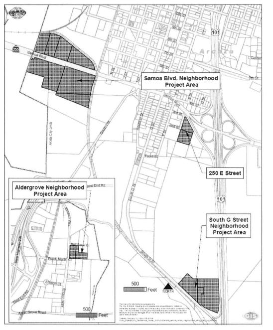
Figure 2-23.1 Housing for Homeless Combining Zone

Figure 2-23.2 Housing for Homeless Combining Zone
(Ord. 1392, eff. 5/15/2009; Ord. No. 1554, eff. 2/4/2022)
9.28.120 Creamery District (:CD) Combining Zone
Repealed by Ord. 1569. (Ord. 1467, eff. 11/20/2015)
9.28.130 Cannabis Innovation Zone (:CIZ) Combining Zone
A. Purpose. The intent of the :CIZ combining zone is to establish an area where niche manufacturing businesses can safely produce cannabis products. Cannabis cultivation, processing, warehousing, research, and testing are allowed. New cannabis product development is strongly encouraged. The :CIZ combining zone was created to stimulate investment, new business creation, and to eliminate blight. The :CIZ combining zone establishes special standards to maintain compatibility with uses allowed in the primary zone.
B. Applicability. The :CIZ combining zone applies to commercial cannabis activities in Areas 1 and 2 as shown in Figure 2-25.
C. Permit Requirements. In addition to any planning permits required in Table 2-10 and any other Federal, State, or local approval, a City of Arcata commercial cannabis activity permit is required for Areas 1 and 2. All commercial cannabis activities in Area 2 require a use permit. The total number of active use permits in Area 2 is limited to 30.
D. Land Use and Development Standards. Proposed development and new land uses within the :CIZ combining zone shall comply with the requirements of the primary zoning district, and all other applicable provisions of this Land Use Code, including accessory uses as authorized by Section 9.42.040. In addition, the following specific regulations apply within the :CIZ combining zone:
1. Cannabis cultivation is an allowable use pursuant to permit requirements indicated by Figure 2-25 and Table 2-10. For the purposes of this Section, the term "cultivation" includes all growing processes from seed to cutting. Cultivation does not include the area where drying or storing of harvested plant or plant material, or nursery activities associated with producing clones, immature plants, seeds, and other agricultural products used specifically for the propagation and cultivation of cannabis occurs. Standards specific to parcels that have cannabis cultivation are as follows:
a. Cultivation area shall be limited to no more than 25 percent of the total building floor area per parcel.
b. Cultivation area shall be no more than 4,000 square feet per lease area or business.
c. Limitations on cultivation area in subsections (D)(1)(a) and (b) of this Section may be exceeded through the issuance of a use permit.
d. Each parcel shall have at least one independently accessible, occupancy ready, commercial or industrial space designed and designated for allowable uses in the primary zone or :CIZ combining zone that is 600 square feet or greater in size, and is not used for cannabis cultivation. This space must be provided prior to receiving a certificate of occupancy for cultivation on parcel.
2. The minimum lot area on Assessor’s Parcel Numbers 507-081-043, 507-121-013, and 507-081-050 shall be reduced to 10,000 square feet.
.2610124.jpg)
Figure 2-25 Cannabis Innovation Zone (:CIZ) Combining Zone
(Ord. 1468, eff. 4/1/2016; Ord. 1488, eff. 7/21/2017; Ord. 1496, eff. 12/20/2017; Ord. 1501, eff. 7/6/2018; Ord. 1516, eff. 8/16/2019; Ord. 1540, eff. 2/19/2021)
9.28.140 Mobilehome Park (:MP) Combining Zone
A. Purpose. The :MP combining zone is intended to create a zone in which mobilehome parks and associated accessory uses are the only allowed uses. This provides exclusive use zoning for the parcels that have base zoning of Residential Medium Density (RM) or Residential High (RH) Density. The City has found that mobilehome parks provide a considerable source of market rate affordable housing, which should be preserved. The :MP overlay zone along with the City’s Mobilehome Park Closure and Conversion ordinance provide a regulatory process to ensure preservation of affordable housing. Any action to close or otherwise change the use of a :MP overlay zoned property may only be allowed if a zone amendment to remove the overlay zone is approved by the City.
B. Applicability. The :MP combining zone is applied to the following mobilehome parks: Town and Country Mobilehome Village, Lazy J Ranch, Valley West Manufactured Home Community, Arcata Mobilehome Park, and Sandpiper Mobilehome Park. The :MP combining zone may be combined with any Residential High (RH) and Residential Medium (RM) zoning districts established by Section 9.12.020 (Zoning Map and Zoning Districts). When combined with a zoning district, the development standards that apply to other residential or commercial developments in the same zone will apply. However, none of the uses in the base zone except Mobilehome Park and Accessory Uses shall be allowed uses.
C. Land use and development standards. Proposed development and new land uses within the :MP combining zone shall comply with the requirements of Section 9.42.120, the primary zoning district, and all other applicable provisions of this Land Use Code.
D. Rezoning. Prior to cessation or any other change of use of a mobilehome park zoned with the :MP overlay, a zone amendment must be processed and approved. In addition to the findings required to adopt a zone amendment described in Chapter 9.92, the following findings must be made by the Review Authority to approve a change of use or zone amendment:
1. All of the requirements of the City of Arcata Mobilehome Park Closure and Conversion Ordinance, including relocation, have been satisfied and approved by the City Council;
2. Replacement housing totaling 20 percent of the total spaces converted is included for low income residents in a new housing project on the subject site or an in-lieu fee determined by multiplying the calculated total of 20 percent of the converted spaces by the per unit replacement value using the most recent affordable housing project built in the City, valuation adjusted for inflation. The in-lieu fee must be deposited in a restricted City account to build affordable housing. (Ord. 1521, eff. 12/20/2019)