


CHAPTER 57 – FORM-BASED CODE FOR THE NE 85TH STREET STATION AREA PLAN
Sections:
57.05 Introduction
57.05.010 Background
57.05.020 Purpose
57.05.030 Development Agreements – Catalyst Projects
57.05.040 How To Use This Code
57.05.050 Review Process
57.05.060 Definitions
57.05.070 Relationship to Other Regulations
57.10 Regulating Districts
57.10.010 Purpose
57.10.020 Applicability
57.10.030 Regulating Plan
57.10.040 Regulating District Standards
57.15 Street Types
57.15.010 Purpose
57.15.020 Applicability
57.15.030 Street Types Map
57.15.040 Using Street Types
57.15.050 Street Types Standards
57.20 Frontage Types
57.20.010 Purpose
57.20.020 Applicability
57.20.030 Frontage Types Components
57.20.040 Frontage Types Standards
57.25 Districtwide Standards
57.25.010 Purpose
57.25.020 Applicability
57.25.030 Rooftop Appurtenances, Amenities, and Structures
57.25.040 Landscaping, Green Infrastructure, and Environmental Features
57.25.050 Transitions
57.25.060 Parking
57.25.070 Transportation Demand Management
57.25.080 Sustainability Standards
57.30 Incentive Zoning Program
57.30.010 Purpose
57.30.020 General Provisions
57.30.030 Required Review
57.30.040 Incentive Amenities and Exchange Rates for Incentive Capacity
57.05 Introduction
57.05.010 Background
The City’s NE 85th Street Station Subarea Plan was adopted in 2022 to support a thriving, new walkable district with high tech and family wage jobs, plentiful affordable housing, sustainable buildings, park amenities, and commercial and retail services linked by transit.
57.05.020 Purpose
Implementation of the vision established in the NE 85th Street Station Subarea Plan requires a comprehensive set of regulations and the supporting design guidelines for the NE 85th St. Station Subarea Plan adopted by reference in Chapter 3.30 KMC. This form-based code is intended to ensure that development in the station area is facilitated by clear and predictable standards that achieve transit-supportive development intensities in a high quality, pedestrian-oriented built environment.
57.05.030 Development Agreements – Catalyst Projects
As a means of encouraging early catalyst transit-oriented development projects within the station area (see Figure 2), projects on sites greater than four acres are encouraged to apply for and negotiate a development agreement with the City pursuant to Chapter 36.70B RCW.
The purpose of such a development agreement is to provide a process for tailoring the regulations and incentives of this chapter as they apply to specific facts and circumstances. A development agreement approved by the City Council pursuant to Chapter 36.70B RCW may approve specific variations or exceptions from the district regulations if the Council finds and concludes in the development agreement that the variations or exceptions result in a project that provides overall greater benefit or overall better mitigation than would a project that strictly complies with the district regulations, except that a development agreement may not authorize (1) additional height above the bonus maximum height; or (2) a use that is not otherwise permitted in the district.
57.05.040 How To Use This Code
This code is organized into four sections:
• Regulating Districts define primary features of overall building form, including lot parameters, massing, height, and permitted uses. A regulating plan (Figure 2) defines the regulating district designation and allowed height for each parcel. These regulating districts are established on the Kirkland Zoning Map and in this chapter.
• Street Types set the design intent for specific segments of public ROW, including prioritized transportation modes, sidewalk and bikeway facility dimensions, and expected streetscape amenities like trees, planting, hardscape, and street furnishings.
• Frontage Types establish design regulations for private property frontages, including the required front setback and building base. Eligible frontage types are determined based on the adjacent street type for a subject property.
• Districtwide Standards apply across the subarea, and include overall transitions, parking, plazas and public spaces, and landscaping and open space.
FIGURE 1: FORM-BASED CODE ELEMENTS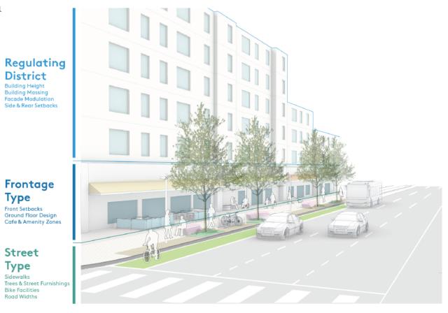
57.05.050 Review Process
This chapter shall be administered by the Planning and Public Works officials through the related development permit process. Design Board review is required for projects that meet the criteria established in KZC 142.15, and which are located in the following zones: Commercial Mixed Use, Neighborhood Mixed Use, Civic Mixed Use. In cases where a development project is subject to Design Board review and this chapter establishes design departures and variation from the requirements in this chapter, the final standard shall be determined by the Design Review Board as established in KZC 142.37, unless otherwise noted. Standards that may be granted design departures and variations by the Design Review Board are:
1. Maximum street level facade width;
2. Minimum facade break width and depth;
3. Required setbacks;
4. Minimum upper story street setbacks;
5. Maximum floor plate;
6. Minimum ground floor parking setbacks;
7. Plaza/public space dimensions;
8. Overhead weather protection.
57.05.070 Relationship to Other Regulations
Development in regulating districts contained in this chapter is subject to the below common code regulations. Unless otherwise stated below, where a provision in a referenced section below conflicts with a specific district or districtwide regulation contained in this chapter, the regulation of that specific district, or districtwide regulation shall govern.
Common Code Regulations. Refer to:
1. Chapter 1 KZC to determine what other provisions of this code may apply to the subject property.
2. KZC 45.50 for public park development standards.
3. Chapter 90 KZC for regulations regarding development near streams, minor lakes (e.g., Forbes Lake), wetlands, fish and wildlife habitat conservation areas and frequently flooded areas.
4. Chapter 85 KZC for regulations regarding development on property containing geologically hazardous areas.
5. Chapter 92 KZC for design regulations.
6. Chapter 95 KZC for regulations regarding tree retention and landscape standards for development on private property.
7. Chapter 105 KZC for parking areas, vehicle and pedestrian access, and related improvements.
8. Chapter 112 KZC for regulations regarding affordable housing standards.
9. Chapter 113 KZC for regulations regarding cottage, carriage, and two-/three-unit homes housing types.
10. Chapter 115 KZC for applicable miscellaneous use development and performance standards.
11. KZC 115.24 for development standards adjoining the Cross Kirkland Corridor. Regulating standards of KZC 115.24 govern where provisions in district or district-wide standards conflict.
12. Chapter 142 KZC for regulations regarding the design review process.
13. Chapter 162 KZC for regulations regarding nonconformances.
(Ord. 4855 § 1, 2023; Ord. 4802 § 1, 2022)
57.10 Regulating Districts
57.10.010 Purpose
Regulating districts are intended to translate the vision and goals documented in the NE 85th St. Station Area Plan adopted by Resolution No. R-5547 into standards that define allowed uses, lot parameters, building massing, and height controls. Regulating districts consist of two elements: a regulating plan that maps these districts to specific parcels and regulating district standards that specify development standards for each district.
57.10.020 Applicability
Regulating districts apply to areas shown on the Kirkland Zoning Map and in the Regulating Plan (Figure 2). They consist of the following zones:
• Commercial Mixed Use (CMU): This zone is intended to encourage uses consistent with large scale commercial and office development. It allows for office, commercial, retail, and civic/institutional uses. Maximum heights are established in the regulating plan and range from 60 feet west of I-405 to 250 feet east of I-405.
• Neighborhood Mixed Use (NMU): This zone is intended to encourage uses consistent with a mixed-use neighborhood that includes commercial development and a range of residential development types. It allows for commercial, civic/institutional, and residential uses. Maximum heights are established in the regulating plan and range from 60 feet west of I-405 to 150 feet east of I-405.
• Urban Flex (UF): This zone is intended to encourage uses consistent with a mixed-use neighborhood that supports light industrial uses consistent with an urban, walkable character. It allows for commercial, retail, civic/institutional, and residential uses. Maximum heights are established in the regulating plan and allow heights up to 45 feet west of I-405.
• Civic Mixed Use (CVU): This zone is intended to encourage uses consistent with a mixed-use environment anchored by civic/institutional uses. It allows for commercial and civic/institutional uses. Maximum heights are established in the regulating plan and allow heights up to 75 feet east of I-405.
57.10.030 Regulating Plan
The regulating plan maps the applicable areas of the form-based code area with the appropriate regulating district designation. Each designation includes two parts: a district designation followed by the height subdistrict for that zone. Heights are stated in terms of maximum base and bonus heights. For instance, CMU 85/150 would reflect a base maximum height allowance of 85 feet and bonus maximum height of 150 feet. Refer to the incentive zoning section of this chapter, KZC 57.30, for details on utilizing the bonus allowances for commercial uses. Residential uses are allowed up to the bonus height allowances by complying with Chapter 112 KZC, Affordable Housing Incentives – Multifamily. Where heights are stated as a single number, that number reflects the maximum height and there are no incentive allowances for additional height.
FIGURE 2: REGULATING PLAN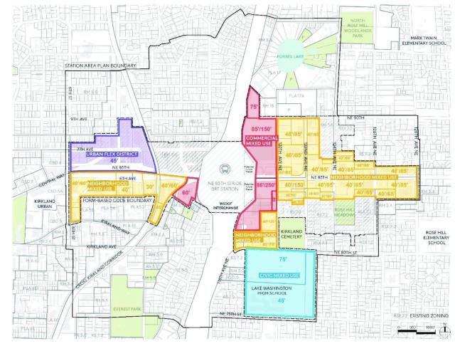
USING THE REGULATING PLAN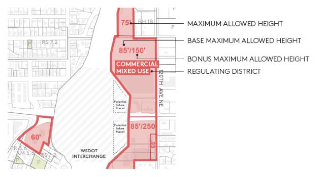
57.10.040 Regulating District Standards
57.10.040.010
General Provisions
Illustrations and graphics are included in this section to assist users in understanding the purpose and requirements of the regulations. In the event a conflict occurs between the text of this section and any illustration or graphic, the text supersedes.
57.10.040.020
Regulating District Components
The following terms and concepts are used in regulating districts to address a lot’s development parameters and building massing. This section is intended to clarify intent; for other definitions, refer to KZC 5.10.
1. Base Maximum Allowed Height is the maximum allowed height of all buildings within a given regulating subdistrict by right, based on the average building elevation as defined in KZC 5.10, unless an alternate height calculation is identified in this chapter.
2. Bonus Maximum Allowed Height is the maximum allowed height of all buildings within a given regulating subdistrict with applicable bonus height, based on the average building elevation as defined in KZC 5.10, unless an alternate height calculation is identified in this chapter. For details on the incentive zoning allowances, see the incentive zoning section of this chapter, KZC 57.30.
3. Building Height Maximums are measured above average building elevation unless a different benchmark is specified.
4. Lot Coverage refers to the area of the maximum lot coverage as defined in KZC 5.10, unless an alternate height calculation is identified in this chapter. For details on the incentive zoning allowances, see the incentive zoning section of this chapter.
5. Maximum Facade Width and Minimum Facade Break Width refer to the horizontal length of a facade parallel to the parcel frontage. Maximum facade width is the maximum allowed distance of a continuous facade wall. Once that maximum facade width is reached, a facade break that modulates the facade and meets a minimum width is required.
6. Maximum Floor Plate is the maximum square footage allowed for each floor of a structure based on floor height. Reductions shall be utilized at the exterior of the building. Maximum floor plate requirements are regulated at increments of floor height above the average building elevation as defined in KZC 5.10 unless an alternate height calculation is identified in this chapter. See Design Guidelines for additional guidance on achieving floor plate reductions.
7. Minimum Tower Separation refers to the horizontal distance between the closest exterior walls of adjacent towers, excluding skybridges, decks, and balconies. “Tower” refers to any portions of buildings greater than 75 feet in height above the average building elevation as defined in KZC 5.10 unless an alternate height calculation is identified in this chapter.
8. Minimum Upper Story Street Setbacks are height-based triggers specified along streets for the building facade to be set back from the back of the required pedestrian clear zone or shared path by a certain horizontal distance. This dimension may be averaged along the full street frontage, so long as no portion of the floor to be set back is less than 50 percent of the required setback distance. These setbacks apply to street-facing exterior walls only.
9. Primary Use refers to the predominant and main land use activity on a site and is the highest and most readily identifiable use that characterizes a property.
10. Vertical Articulation refers to a required articulation of street-facing facades at 45 feet in height across the full width of the facade. For design guidance in achieving vertical articulation, refer to design guidelines for the NE 85th St. Station Subarea Plan.
57.10.040.030
Continued Uses
1. Applicability
Primary and accessory uses in existence in the Station Area, as defined by the regulating plan (Figure 2), at the time of adoption of this chapter, that become nonconforming uses as a result of the provisions of this chapter, may continue as legal nonconforming uses.
2. Continued Uses and Minor Expansions
Structures in existence at the time of adoption of this chapter that became nonconforming structures solely as a result of the provisions in this chapter shall be deemed legally conforming structures for purposes of maintenance, repair, and replacement, and may be enlarged by up to 10 percent of the existing footprint or existing gross floor area without complying with the provisions of this chapter. Enlargement of such structures or addition of new structures that exceed existing gross floor area or existing footprint by more than 10 percent shall comply with the provisions of this chapter, except that an applicant may request an exception to allow enlargement by more than 10 percent without complying with all provisions of this chapter if they can demonstrate to the satisfaction of the Planning and Building Director that it is not reasonable and practicable for such enlargement to comply with this chapter; or that such enlargement will not materially increase the nonconformity of the subject property in a manner contrary to the stated purpose of this chapter. Any enlargement of more than 50 percent of the footprint in existence at the time of adoption of this chapter shall conform to this chapter, except as provided in the next section.
3. Special Provisions for Continued Uses With Development Agreements
Subject properties greater than 10 acres in size with large-format retail sales uses in existence at the time of adoption of this chapter may redevelop or expand the structures associated with such uses by more than 10 percent of the existing gross floor area or existing footprint by means of a development agreement adopted pursuant to RCW 36.70B.170 et seq. (“development agreement”).
In the development agreement, the City Council may approve administrative modifications and adjustments to the Station Area regulations as reasonably required to facilitate the following:
a. Expansion of retail buildings, modification of the existing parking layouts, expansion, or development of existing or new accessory uses, modifications to surface parking or the addition of structured parking, and enlargement of allowed floor plates.
b. Redevelopment of a subject property with a large-format retail sales use by more than 50 percent of the existing gross floor area or existing footprint shall comply with the Station Area regulations and intent of the form-based code to the extent reasonably practicable subject to operational requirements for such uses.
c. The continued sale of gasoline and diesel fuel shall be permitted as an accessory use to an existing large-format retail sales use. A car wash is also authorized as an accessory use to a large-format retail sales use.
57.10.040.040
Commercial Mixed Use
1. Permitted Uses
Table 1 specifies permitted uses for this zone.
|
General Use |
Commercial Mixed Use (CMU) Permitted (P)/Not Permitted (NP) |
|---|---|
|
Commercial |
P |
|
Institutional |
P |
|
Residential |
NP |
|
Industrial |
NP |
|
Uses Specifically Prohibited as Primary Use |
|---|
|
Automotive Service Station |
|
Sale, Service, Storage, and/or Rental of Motor Vehicles, Sailboats, Motor Boats, and Recreational Trailers |
|
Drive-Through Facilities |
2. Sign Category (Chapter 100 KZC)
All permitted uses within the Commercial Mixed Use District shall comply with Sign Category E unless otherwise specified in a development agreement or if a development receives bonus height. Developments that receive bonus height must have their signs proposed and approved as part of a master sign plan pursuant to KZC 100.80 and follow the guidelines described in the design guidelines for the NE 85th St. Station Subarea Plan.
FIGURE 3: COMMERCIAL MIXED USE DISTRICT STANDARDS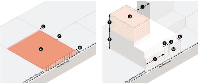
|
LOT COVERAGE AND SETBACKS |
MASSING AND DEVELOPMENT DENSITY |
|||||
|---|---|---|---|---|---|---|
|
|
Permitted Uses |
|
|
Maximum Height and Floor Area |
||
|
|
General Permitted Uses |
Commercial, Institutional |
|
|
Base Maximum Allowed Height |
Refer to Regulating Plan |
|
|
Lot Coverage |
|
|
Bonus Maximum Allowed Height |
Refer to Regulating Plan |
|
|
|
Max Lot Coverage* |
90% |
|
|
Maximum Floor Plate (per building) |
45'-75': 35,000 GSF 75'-125': 25,000 GSF Above 125': 20,000 GSF |
|
|
|
|
Facade Design |
|||
|
|
Front |
Refer to Frontage Types |
|
|
Maximum Facade Width |
160' |
|
|
Side |
0' Min |
|
|
Minimum Facade Break Width |
15' |
|
|
Rear |
5' Min |
|
|
Minimum Facade Break Depth |
5' |
|
|
*Lot coverage as shown does not represent intended building placement or setbacks. Properties adjoining the Cross Kirkland Corridor are also subject to the standards of KZC 115.24. |
|
|
Upper Story Massing |
||
|
|
|
Upper Story Street Setbacks |
At 75': 15' setback At 125': 30' setback |
|||
|
|
|
|
Tower Separation |
60' |
||
|
|
|
|
Vertical Articulation |
Required at 45' Refer to Design Guidelines for recommended articulation strategies. |
||
57.10.040.050
Neighborhood Mixed Use
1. Permitted Uses
Table 2 specifies permitted uses for this zone.
|
General Use |
Neighborhood Mixed Use (NMU) Permitted (P)/Not Permitted (NP) |
|---|---|
|
Commercial |
P |
|
Institutional |
P |
|
Residential |
P |
|
Industrial |
NP |
|
Uses Specifically Prohibited as Primary Use |
|---|
|
Automotive Service Station |
|
Sale, Service, Storage, and/or Rental of Motor Vehicles, Sailboats, Motor Boats, and Recreational Trailers |
|
Drive-Through Facilities |
2. Sign Category (Chapter 100 KZC)
All permitted uses within the Neighborhood Mixed Use District shall comply with Sign Category E unless otherwise specified in a development agreement or if a development receives bonus height. Developments that receive bonus height must have their signs proposed and approved as part of a master sign plan pursuant to KZC 100.80 and follow the guidelines described in the design guidelines for the NE 85th St. Station Subarea Plan.
FIGURE 4: NEIGHBORHOOD MIXED USE DISTRICT STANDARDS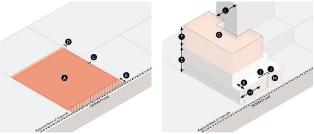
|
LOT COVERAGE AND SETBACKS |
MASSING AND DEVELOPMENT DENSITY |
|||||
|---|---|---|---|---|---|---|
|
|
Permitted Uses |
|
|
Maximum Height and Floor Area |
||
|
|
General Permitted Uses |
Commercial, Institutional, Residential |
|
|
Base Maximum Allowed Height |
Refer to Regulating Plan |
|
|
Lot Coverage |
|
|
Bonus Maximum Allowed Height |
Refer to Regulating Plan |
|
|
|
Max Lot Coverage* |
90% |
|
|
Maximum Floor Plate (per building) |
45'-75': 30,000 GSF 75'-85': 25,000 GSF Above 85': 15,000 GSF |
|
|
Required Setbacks |
|
|
Facade Design |
||
|
|
Front |
Refer to Frontage Types |
|
|
Maximum Facade Width |
120' |
|
|
Side |
0' Min |
|
|
Minimum Facade Break Width |
10' |
|
|
Rear |
5' Min |
|
|
Minimum Facade Break Depth |
5' |
|
|
*Lot coverage as shown does not represent intended building placement or setbacks. |
|
|
Upper Story Massing |
||
|
|
|
|
|
Upper Story Street Setbacks |
At 75': 15' setback At 100': 30' setback |
|
|
|
|
|
|
|
Tower Separation |
60' |
|
|
|
|
|
|
Vertical Articulation |
Required at 45' Refer to Design Guidelines for recommended articulation strategies. |
57.10.040.060
Neighborhood Residential
Reserved.
57.10.040.070
Urban Flex
1. Permitted Uses
Table 3 specifies permitted uses for this zone.
|
General Use |
Urban Flex (UF) Permitted (P)/Not Permitted (NP) |
|---|---|
|
Commercial |
P |
|
Institutional |
P |
|
Residential |
P* |
|
Industrial |
P |
*See section below on residential uses.
|
Uses Specifically Prohibited as Primary Use |
|---|
|
Automotive Service Station |
|
Sale, Service, Storage, and/or Rental of Motor Vehicles, Sailboats, Motor Boats, and Recreational Trailers |
|
Drive-Through Facilities |
Residential uses are not permitted on the street level floor, except for residential lobbies.
3. Sign Category (Chapter 100 KZC)
All residential uses shall comply with Sign Category A. Institutional uses shall comply with Sign Category B. Commercial uses shall comply with Sign Category E.
FIGURE 5: URBAN FLEX DISTRICT STANDARDS
|
LOT COVERAGE AND SETBACKS |
MASSING AND DEVELOPMENT DENSITY |
|||||
|---|---|---|---|---|---|---|
|
|
Permitted Uses |
|
|
Maximum Height and Floor Area |
||
|
|
General Permitted Uses |
Light Industrial, Commercial, Institutional, Residential |
|
|
Base Maximum Allowed Height |
Refer to Regulating Plan |
|
|
Lot Coverage |
|
|
Facade Design |
||
|
|
Max Lot Coverage* |
90% |
|
|
Maximum Facade Width |
160' |
|
|
Required Setbacks |
|
|
Minimum Facade Break Width |
15' |
|
|
|
Front |
Refer to Frontage Types |
|
|
Minimum Facade Break Depth |
5' |
|
|
Side |
0' Min |
|
|
|
|
|
|
Rear |
5' Min |
|
|
|
|
|
|
*Lot coverage as shown does not represent intended building placement or setbacks. Properties adjoining the Cross Kirkland Corridor are also subject to the standards of KZC 115.24. |
|
|
|
||
57.10.040.080
Civic Mixed Use
1. Permitted Uses
Table 4 specifies permitted uses for this zone.
|
General Use |
Civic Mixed Use (CVU) Permitted (P)/Not Permitted (NP) |
|---|---|
|
Commercial |
P |
|
Institutional |
P |
|
Residential |
P |
|
Industrial |
NP |
|
Uses Specifically Prohibited as Primary Use |
|---|
|
Automotive Service Station |
|
Sale, Service, Storage, and/or Rental of Motor Vehicles, Sailboats, Motor Boats, and Recreational Trailers |
|
Drive-Through Facilities |
2. Sign Category (Chapter 100 KZC)
All residential uses shall comply with Sign Category A. Institutional uses shall comply with Sign Category B. Commercial uses shall comply with Sign Category E.
FIGURE 6: CIVIC MIXED USE DISTRICT STANDARDS
|
LOT COVERAGE AND SETBACKS |
MASSING AND DEVELOPMENT DENSITY |
|||||
|---|---|---|---|---|---|---|
|
|
Permitted Uses |
|
|
Maximum Height and Floor Plate |
||
|
|
General Permitted Uses |
Commercial, Institutional, Residential |
|
|
Base Maximum Allowed Height |
Refer to Regulating Plan |
|
|
Lot Coverage |
|
|
Bonus Maximum Allowed Height |
Refer to Regulating Plan |
|
|
|
Max Lot Coverage* |
80% |
|
|
Maximum Floor Plate (per building) |
45'-75': 30,000 SF |
|
|
Required Setbacks |
|
|
Facade Design |
||
|
|
Front |
Refer to Frontage Types |
|
|
Maximum Facade Width |
120' |
|
|
Side |
5' Min |
|
|
Minimum Facade Break Width |
10' |
|
|
Rear |
5' Min |
|
|
Minimum Facade Break Depth |
5' |
|
|
*Lot coverage as shown does not represent intended building placement or setbacks. |
|
|
|
||
(Ord. 4855 § 1, 2023; Ord. 4802 § 1, 2022)
57.15 Street Types
57.15.010 Purpose
Street types are intended to translate the vision and goals documented in the NE 85th St. Station Area Plan into standards that provide direction for improvements to public and private right-of-way. These street types specify typical dimensions, transportation mode considerations for appropriate facilities, and guidance on how public rights-of-way and private and frontage improvements can work together to create a cohesive, pleasant public realm.
57.15.020 Applicability
Street types apply to areas shown in the Street Types Map, in Figure 7. They consist of the following types:
• Major Thoroughfares connect regional centers or run through central commercial corridors. Many of these streets have significant traffic volumes at peak hours and are important places for high-capacity transit routes and protected bike facilities.
• Main Streets are special streets that concentrate ground-floor retail and active uses, often with generous public realm designed to prioritize pedestrian activity.
• Neighborhood Mixed Use streets are neighborhood streets serving low- to mid-intensity commercial and midrise residential and occasional ground floor retail. They are generally lower vehicular traffic volume than major thoroughfares, and some may contain bike facilities and transit service.
• Neighborhood Residential streets are residentially focused with low vehicular traffic volumes, which may accommodate designated bikeways or neighborhood greenways depending on roadway speeds and volumes.
• Green Mid-Block Connections provide important network connections for cyclists and pedestrians through and across long blocks and are typically found within larger commercial or residential developments or between existing parcels. In addition to providing bike and pedestrian access, they can also include on-site green stormwater infrastructure as part of their design, or where accommodating vehicle access, provide delivery and back of house access to parcels.
57.15.030 Street Types Map
The Street Types Map shows the designated street type classification for each street segment within the regulating districts.
FIGURE 7: STREET TYPES MAP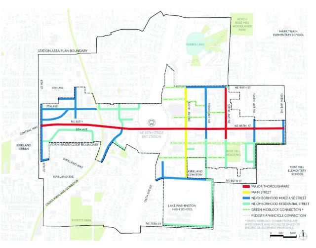
57.15.040 Using Street Types
1. Individual Treatments – These street types reflect the general intent for improvements of the public right-of-way, and guidance for development of private rights-of-way within private parcels. Specific designs for each street are subject to change based on site conditions or existing right-of-way conditions. In these cases, the Public Works Official shall determine how the proposed design meets the urban design and mobility intent of the designated street type.
2. Street Type Elements – Street types are comprised of the following elements:
a. Pedestrian Clear Zone: the primary, accessible portion of the sidewalk that runs parallel to the street. This zone must be clear of obstructions and elements that could impede pedestrian travel.
b. Furnishing Zone: the section of the sidewalk between the curb and the pedestrian clear zone in which street furniture and amenities, such as lighting, benches, utility poles, tree pits, and green infrastructure are provided.
c. Bikeway: the portion of the right-of-way exclusively dedicated to bicycle travel. This can include a variety of facilities, including designated bike lanes, at-grade protected bike lanes or grade-separated (sidewalk level) protected bike lanes. Bicycle riders may also use other facility types that are not exclusive bikeways, but shared facilities such as neighborhood greenways, which are low volume, low speed streets, with signage, pavement markings, and traffic-calming elements to prioritize pedestrian and bicycle travel; or shared-use bicycle and pedestrian facilities such as temporary on-street paths or off-street shared-use paths or trails.
d. Roadway: the area between curbs, which can include travel lanes, on-street parking, and bikeways.
3. Preferred and Minimum Dimensions – The street types show dimensions that reflect the desired space allocation for each portion of the right-of-way. The table below shows preferred and minimum dimensions for street type elements for each street type. Preferred dimensions should be constructed, except where the Public Works Official determines allowed deviations from these dimensions pursuant to modification procedures in KZC 110.70.
|
Pedestrian Clear Zone |
Bikeway*** |
Furnishing Zone |
Travel Lane Width*** |
Number of Travel Lanes (Typical) |
On-Street Parking Permitted (Typical) |
|
|---|---|---|---|---|---|---|
|
Major Thoroughfare |
10'/8' |
6'* |
10'/8' |
10' |
5-6 |
No |
|
Main Street |
10'/6' |
6'* |
6'/5' |
10' |
2-3 |
Varies |
|
Neighborhood Mixed Use |
8'/6' |
7' buffered bike lane/5' bike lane |
6'/5' |
10' |
2 |
Varies |
|
Neighborhood Residential |
6'/5' |
Varies by configuration, see examples |
6'/5' |
10' |
2 |
Varies by configuration |
|
Green Mid-Block** Connection |
6'-12', varies by configuration |
Varies by configuration, see examples |
4'-6', varies by configuration |
10', if vehicle access allowed |
2, if vehicle access allowed |
Varies by configuration |
* Includes one foot separation between pedestrian and bike zones.
** See Figure 13, Green Mid-Block Connection, for alternative configurations.
*** Exclusive of gutter pan.
**** Refer to 120th Ave NE corridor study for conceptual design.
57.15.050 Street Types Standards
FIGURE 8: MAJOR THOROUGHFARE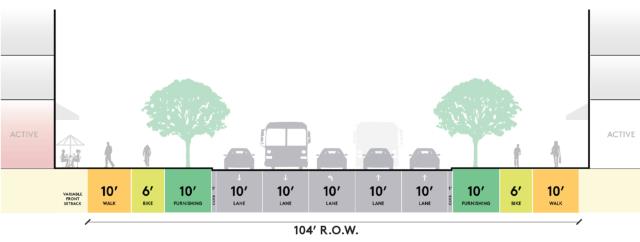
|
Description |
Permitted Frontage Types |
||||||
|---|---|---|---|---|---|---|---|
|
Major thoroughfares are streets that connect regional centers or pass through central commercial corridors. Many of these streets have significant traffic volumes at peak hours, and are key places for high-capacity transit routes, separated bike facilities, and wider sidewalks. |
|
URBAN STREET EDGE |
RETAIL AND ACTIVE USES |
RESIDENTIAL STOOP/PORCH |
PLAZA/PUBLIC SPACE |
PRIVATE YARD |
|
|
|
Permitted |
Permitted |
Not Permitted |
Permitted |
Not Permitted |
||
|
|
FUNCTIONAL CLASSES |
Principal Arterial |
|||||
|
|
ADJACENT LAND USES |
High intensity commercial, residential, and active ground-level uses |
|||||
FIGURE 9: MAIN STREET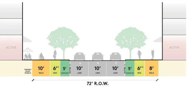
|
Description |
Permitted Frontage Types |
||||||
|---|---|---|---|---|---|---|---|
|
Main streets are primary pedestrian corridors with active uses and generous sidewalks. They feature high quality streetscapes with linear open space, decorative paving, and tree canopy. These are often important corridors for transit or supported with transit nearby. On-street parking may be accommodated where center turn lanes are not needed, or additional ROW dedication is provided. *Includes one foot separation between pedestrian and bike zones. |
|
URBAN STREET EDGE |
RETAIL AND ACTIVE USES |
RESIDENTIAL STOOP/PORCH |
PLAZA/PUBLIC SPACE |
PRIVATE YARD |
|
|
|
Permitted |
Permitted |
Not Permitted |
Permitted |
Not Permitted |
||
|
|
FUNCTIONAL CLASSES |
Minor Arterial, Collector |
|||||
|
|
ADJACENT LAND USES |
Mid to high intensity commercial, residential, and ground-level retail uses |
|||||
FIGURE 10: NEIGHBORHOOD MIXED USE STREET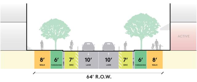
|
Description |
Permitted Frontage Types |
||||||
|---|---|---|---|---|---|---|---|
|
Neighborhood mixed use streets have low- to mid-intensity commercial and residential, occasionally active ground floors. With generally lower vehicular volume than major thoroughfares, these streets require careful balancing among modes and should include wider sidewalks, buffered bike facilities, transit routes, and narrower travel lanes. On-street parking is considered on a contextual basis and is subject to approval by Public Works Official. |
|
URBAN STREET EDGE |
RETAIL AND ACTIVE USES |
RESIDENTIAL STOOP/PORCH |
PLAZA/PUBLIC SPACE |
PRIVATE YARD |
|
|
|
Permitted |
Permitted |
Permitted |
Permitted |
Permitted |
||
|
|
FUNCTIONAL CLASSES |
Minor Arterial, Collector, Neighborhood Access |
|||||
|
|
ADJACENT LAND USES |
Low- to mid-intensity commercial, residential, and occasionally active ground-level uses, civic and urban flex uses |
|||||
FIGURE 11: NEIGHBORHOOD RESIDENTIAL STREET TYPE 1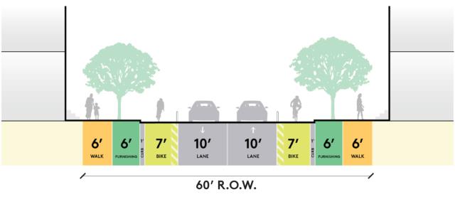
|
Description |
Permitted Frontage Types* |
||||||
|---|---|---|---|---|---|---|---|
|
Neighborhood residential streets are low vehicular traffic volume streets that have primarily residential frontages and dedicated bicycle facilities. On-street parking may be considered in locations with wider ROW. |
|
URBAN STREET EDGE |
RETAIL AND ACTIVE USES |
RESIDENTIAL STOOP/PORCH |
PLAZA/PUBLIC SPACE |
PRIVATE YARD |
|
|
|
Not Permitted |
Not Permitted |
Permitted |
Permitted |
Permitted |
||
|
|
FUNCTIONAL CLASSES |
Collector |
|||||
|
|
ADJACENT LAND USES |
Predominantly low- to medium-intensity residential uses |
|||||
|
|
|
*Permitted frontage types within the Urban Flex Regulating District include urban street edge, retail and active uses, and plaza/public space. Residential stoop/porch and private yard frontage types are prohibited. |
|||||
FIGURE 12: NEIGHBORHOOD RESIDENTIAL STREET TYPE 2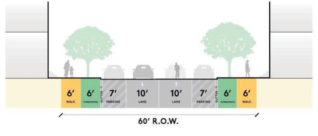
|
Description |
Permitted Frontage Types |
||||||
|---|---|---|---|---|---|---|---|
|
Residential-focused streets with low vehicular traffic volumes, which can accommodate shared bike facilities. |
|
URBAN STREET EDGE |
RETAIL AND ACTIVE USES |
RESIDENTIAL STOOP/PORCH |
PLAZA/PUBLIC SPACE |
PRIVATE YARD |
|
|
|
Not Permitted |
Not Permitted |
Permitted |
Permitted |
Permitted |
||
|
|
FUNCTIONAL CLASSES |
Neighborhood Access |
|||||
|
|
ADJACENT LAND USES |
Predominantly low- to medium-intensity residential uses |
|||||
|
|
|
*Permitted frontage types within the Urban Flex Regulating District include urban street edge, retail and active uses, and plaza/public space. Residential stoop/porch and private yard frontage types are prohibited. |
|||||
FIGURE 13: GREEN MID-BLOCK CONNECTION
|
Description |
Permitted Frontage Types |
||||||
|---|---|---|---|---|---|---|---|
|
These streets are generously landscaped mid-block connections typically as part of larger developments. May include required green infrastructure. Does not include public ROW improvements to “green” an existing street. Mid-block connections may be used for emergency access, and may also be used for access to loading zones, parking entrances, or other “back of house” functions. *Edge refers to a material change at the same grade that transitions from travel lane to furnishing zone. |
|
URBAN STREET EDGE |
RETAIL AND ACTIVE USES |
RESIDENTIAL STOOP/PORCH |
PLAZA/PUBLIC SPACE |
PRIVATE YARD |
|
|
|
Permitted |
Permitted |
Permitted |
Permitted |
Permitted |
||
|
|
FUNCTIONAL CLASSES |
Neighborhood Access, Trail |
|||||
|
|
ADJACENT LAND USES |
Low- to high-intensity commercial or residential uses, typically within larger developments. May have active ground-level uses, depending on site design. |
|||||
(Ord. 4855 § 1, 2023; Ord. 4802 § 1, 2022)
57.20 Frontage Types
57.20.010 Purpose
Frontage types are intended to create a cohesive public realm by regulating the relationship between private development and the public right-of-way.
57.20.020 Applicability
Permitted frontage types are defined based on the street type designation of each street segment within the regulating districts as shown in Figure 7. A structure can apply more than one allowed frontage type along same street frontage. Application of a frontage type requires a minimum of 30 feet measured horizontally along the building facade, unless the building facade itself is less than 30 feet. The following types of frontages are permitted within the regulating districts:
• Urban Street Edge: This frontage type is intended to establish a public realm consistent with a walkable mixed use environment. Characteristics include buildings set close to the public sidewalk, pedestrian-oriented facades, and landscaping that contributes to an urban environment.
• Active Use/Retail: This frontage type is intended to foster a dynamic public realm anchored by active uses on the street level floor, including retail, institutional, or other public-facing uses.
• Residential Stoop/Porch: This frontage type is intended to establish a consistent, walkable residential frontage defined by buildings that engage the public right-of-way by inclusion of elements that reflect individual residential units like direct entries, articulated facades, and elevated stoops and porches.
• Plaza/Public Space: This frontage type is intended to support the creation of publicly accessible public space within the district. It is characterized by high quality landscaping, pedestrian-oriented amenities like seating, fountains, and artwork, and buildings that engage the open space with elements like primary entries and storefronts.
• Private Yard: This frontage type is intended to establish a streetscape with landscaped front yards, a visual connection to primary buildings from the sidewalk, and street wall edges maintained with elements like low fences, low walls and low height vegetation.
57.20.030 Frontage Types Components
The following terms and concepts are used to address the elements of frontage types. This section is intended to clarify intent; for full definitions, refer to KZC 5.10.
1. Building Frontage Amenity Zones are portions of the frontage located between building facade and the back of the required sidewalk width that can be designed to support an active pedestrian-scaled street experience. For amenities with seating for outdoor dining, minimum depths are required to ensure adequate space.
2. Corner Design refers to the treatment of building facades at the intersection of specific street types. Facades shall be buffered from the corner property lines at a 45-degree angle behind a specified area within the property line at corners where the intersecting streets are a major thoroughfare, main street, or neighborhood mixed use street type. Corner design regulations apply to the full height of the building facade within the applicable area. For design guidance on how to achieve the desired corner design, refer to design guidelines for the NE 85th Street Station Subarea Plan.
3. Facade Transparency refers to the minimum total transparent area of the building facade between two feet and 10 feet above the street level floor elevation. Illustrations are not otherwise intended to reflect specific location requirements.
4. Front Setback is the area from the back of the required sidewalk width where the building exterior wall should be located. It is expressed as minimum and maximum distance.
5. Frontage refers to a street-facing portion of a lot to a maximum depth of 50 feet from the required back of sidewalk.
6. Entrance Location is intended to orient a primary building entrance along the frontage facing the street. Entrance locations shown in graphics depict one conforming design, but do not reflect specific location requirements.
7. Entrance Spacing refers to the linear horizontal distance between the closest points of entrances along a frontage.
8. Entrance Transparency is the minimum total transparency percentage of the entrance, which includes the gross area of the outer edge of doors and transoms.
9. Minimum Ground Floor Parking Setback refers to a horizontal setback from the frontage building facade that is required for any parking uses. Building area within this setback must be designed for use as residential, commercial, or institutional use consistent with applicable permitted uses.
10. Maximum Street Level Facade Width refers to the division of the street level floor of a building facade into vertical sections that reduce perceived bulk, create visual interest, and reflect the vision and objectives of the NE 85th Street Station Area Plan to create a pedestrian-oriented district. For design guidance in achieving maximum street level facade widths, refer to Design Guidelines for the NE 85th Street Station Subarea Plan.
11. Overhead Weather Protection refers to building projections or structures that provide shelter from rain and other weather-related impacts to the pedestrian experience. For design guidance in providing overhead weather protection, refer to additional standards in KZC 57.20.040.060 and the design guidelines for the NE 85th Street Station Subarea Plan.
12. Street Level Floor refers to the first floor accessible from sidewalk, consistent with the definition in KZC 5.10. This is also referred to as ground floor.
13. Street Level Floor Story Height refers to the floor-to-floor height of this pedestrian-oriented story.
57.20.040 Frontage Type Standards
57.20.040.010
Urban Street Edge
1. Intent and Character – The Urban Street Edge frontage type is intended to establish a public realm consistent with a walkable mixed use environment. Characteristics include buildings set close to the public right-of-way, pedestrian-oriented facades, and landscaping that contributes to an urban environment. Examples consistent with the intent of this frontage type are shown in Figure 14.
FIGURE 14: CHARACTER EXAMPLES FOR URBAN STREET EDGE FRONTAGE TYPE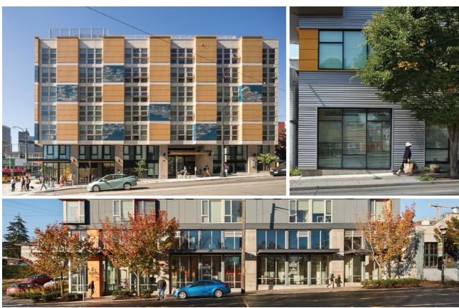
FIGURE 15: URBAN STREET EDGE FRONTAGE STANDARDS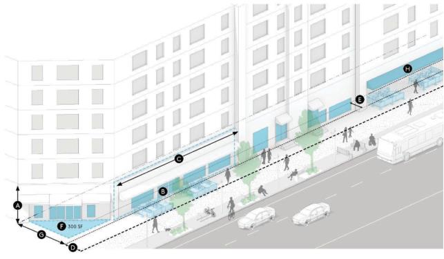
|
GROUND FLOOR DESIGN AND ENTRY |
PUBLIC REALM |
|||||
|---|---|---|---|---|---|---|
|
|
Ground Floor Design |
|
|
Public Realm |
||
|
|
Minimum Height |
15' |
|
|
Front Setbacks (Min, Max) |
0', 15' |
|
|
Facade Transparency |
50% |
|
|
Sidewalk Cafes/Amenity Zone |
Min depth 7', up to 10' additional setback allowed |
|
|
Max Street Level Facade Width |
65' |
|
|||
|
|
Entrances |
|
|
Corner Design |
Minimum 300 SF required within property line at street corners |
|
|
|
Location |
Required on primary street-facing frontage |
|
|
Ground Floor Parking Setback |
Average 30', Minimum 20' |
|
|
Entry Transparency |
80% |
|
|
Overhead Weather Protection |
Required for a minimum of 70% for all street-facing facades. See frontage type additional standards for specific requirements |
57.20.040.020
Retail/Active Use
1. Intent and Character – The Retail/Active Use frontage type is intended to foster a dynamic public realm anchored by active uses on the ground floor, including retail, civic, or other public-facing uses. Examples consistent with the intent of this frontage type are shown in Figure 16.
FIGURE 16: CHARACTER EXAMPLES FOR RETAIL/ACTIVE USE FRONTAGE TYPE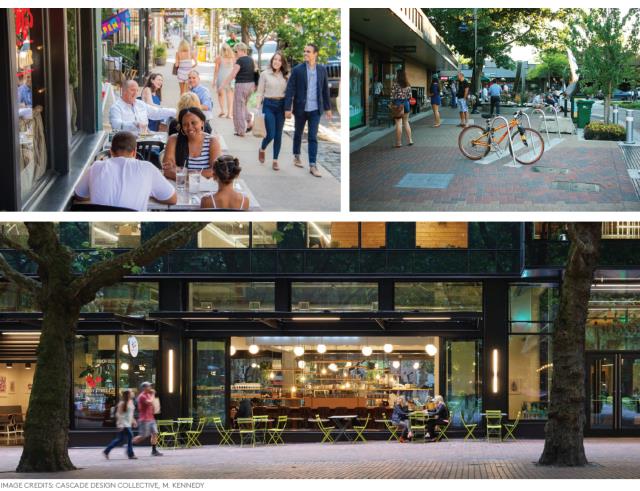
FIGURE 17: RETAIL AND ACTIVE USES FRONTAGE STANDARDS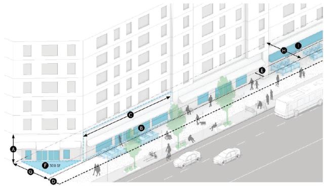
|
GROUND FLOOR DESIGN AND ENTRY |
PUBLIC REALM |
|||||
|---|---|---|---|---|---|---|
|
|
Ground Floor Design |
|
|
Public Realm |
||
|
|
Minimum Street Level Story Height |
15' |
|
|
Front Setbacks (Min, Max) |
0',15' |
|
|
Facade Transparency |
75% |
|
|
Sidewalk Cafes/Amenity Zone |
Min depth 7', up to 10' additional setback allowed |
|
|
Max Street Level Facade Width |
65' |
|
|||
|
|
Entrances |
|
|
Corner Design |
Minimum 300 SF required within property line at street corners |
|
|
|
Location |
Required on primary street-facing frontage |
|
|
Ground Floor Parking Setback |
25' |
|
|
Entry Transparency |
80% |
|
|
Active Ground Floor Depth |
Average 30' |
|
|
|
|
|
|
Overhead Weather Protection |
Required for a minimum of 90% for all street-facing facades. See frontage type additional standards for specific requirements |
57.20.040.030
Residential Stoop/Porch
1. Intent and Character – This frontage type is intended to establish a consistent, walkable residential frontage defined by buildings that engage the public right-of-way, elements that reflect individual residential units like direct entries and articulated facades, and elevated stoops and porches.
FIGURE 18: CHARACTER EXAMPLES FOR RESIDENTIAL STOOP/PORCH FRONTAGE TYPE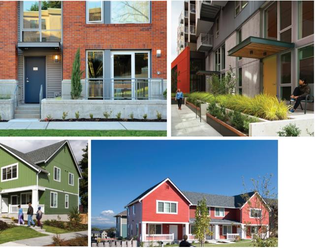
FIGURE 19: RESIDENTIAL STOOP/PORCH FRONTAGE STANDARDS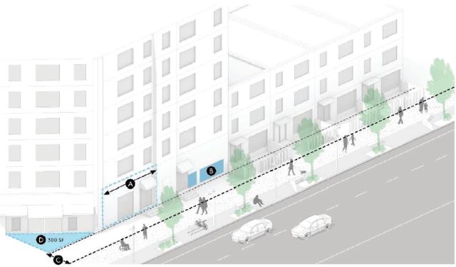
|
GROUND FLOOR DESIGN AND ENTRY |
PUBLIC REALM |
|||||
|---|---|---|---|---|---|---|
|
|
Ground Floor Design |
|
|
Public Realm |
||
|
|
Max Street Level Facade Width |
36' |
|
|
Front Setbacks (Min, Max) |
5',10' |
|
|
Facade Transparency |
50% |
|
|||
|
|
Entrances |
|
|
|
Corner Design |
Minimum 300 SF required within property line at street corners |
|
|
Location |
Required at frontage, otherwise entry path can be used |
|
|
|
|
2. Residential Stoop/Porch Additional Standards
a. Allowances Within Front Setbacks
1) Porches and steps connected to building entrances are allowed to extend up to five feet into the front setback area. For structures less than 18 inches above finished grade, refer to KZC 115.115.
2) Porches must meet the following requirements:
a) The finished floor of the porch is no more than four feet above finished grade;
b) Three sides of the porch are open;
c) The porch roof form is architecturally compatible with the roof form of the dwelling unit to which it is attached;
d) If the porch is covered, is no higher than one story.
3) Low walls are allowed within the front setback, provided they are no taller than three feet.
57.20.040.040
Plaza/Public Space
1. Intent and Character – This frontage type is intended to support the creation of publicly accessible open space within the district. It is characterized by high quality landscape materials, pedestrian-oriented amenities like seating, fountains, and artwork, and buildings that engage the public space with elements like outdoor seating areas, primary building entrances, and transparent facades.
FIGURE 20: CHARACTER EXAMPLES FOR PLAZA/PUBLIC SPACE FRONTAGE TYPE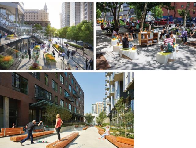
FIGURE 21: PLAZA/PUBLIC SPACE FRONTAGE STANDARDS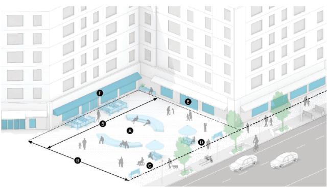
|
PUBLIC SPACE SIZE |
RELATIONSHIP TO SIDEWALKS AND BUILDINGS |
|||||
|---|---|---|---|---|---|---|
|
|
Dimensions |
|
|
Relationship to Sidewalks |
||
|
|
Minimum Area |
Min 2,000 SF, 75% occupiable by pedestrians |
|
|
Access |
ADA accessible for pedestrians from adjacent sidewalk |
|
|
Minimum Dimension |
Average 30' |
|
|
Visibility |
Minimum 2,000 sq.ft of plaza must be visible from frontage sidewalk |
|
|
|
|
Relationship to Buildings |
|||
|
|
|
Building Frontage |
Buildings should match standards for other allowed frontages and be oriented towards public space |
|||
|
|
|
|
|
|
Overhead Weather Protection |
Required for a minimum of 70% for all street-facing facades. See frontage type additional standards for specific requirements |
2. Plaza/Open Space Additional Standards
a. Dimensions
1) Minimum Area: Plazas must be a minimum area of 2,000 square feet. Seventy-five percent of this must be occupiable by pedestrians.
2) Minimum Dimension: Plazas must maintain either a 30-foot minimum average width measured along the property boundary or a 30-foot minimum average depth measured perpendicular to the property boundary.
b. Relationship to Sidewalk
1) Access: Plazas must be accessible to pedestrians from adjacent sidewalks, either by maintaining an at sidewalk grade transition to frontage grade or by providing a combination of steps, ramps, or other ADA accessible means of moving easily from sidewalk to plaza. At least 30 percent of the plaza frontage must be free of barriers or other obstructions to pedestrian access.
2) Visibility: At least 2,000 square feet of the plaza must be visible (e.g., free from obstructions such as walls, hedges or other dense vegetation, furniture, etc.) from the adjacent sidewalk to each plaza frontage.
c. Relationship to Buildings
1) Orientation: Building walls that are adjacent to plazas must orient windows, entrances, and other frontage elements towards the plaza.
2) Frontage Type: Building facades with more than 20 feet of linear frontage along a plaza must identify a frontage type which is permitted for the relevant street type, and design to the standards of that frontage type. Examples of other frontages would include urban street, retail and active uses, or residential porch/stoop.
57.20.040.050
Private Yard
1. Intent and Character – This frontage type is intended to establish a streetscape with landscaped front yards, a visual connection to primary buildings from the sidewalk, and street wall edges maintained with elements like low fences, low walls and low height vegetation.
FIGURE 22: CHARACTER EXAMPLES FOR PRIVATE YARD FRONTAGE TYPE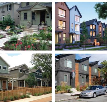
FIGURE 23: PRIVATE YARD FRONTAGE STANDARDS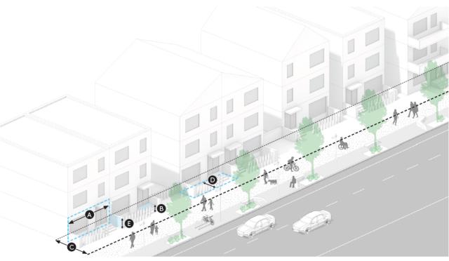
|
GROUND FLOOR DESIGN AND ENTRY |
PUBLIC REALM |
|||||
|---|---|---|---|---|---|---|
|
|
Ground Floor Design |
|
|
Public Realm |
||
|
|
Max Street Level Facade Width |
35' |
|
|
Front Setbacks (Min, Max) |
10', 20' |
|
|
Entrances |
|
|
|
Allowed Encroachment |
Maximum 5' |
|
|
Location |
Required at frontage |
|
|
Low Wall |
Maximum 3' |
|
|
Porch Height |
Maximum 4' |
|
|
|
|
2. Private Yard Additional Standards
a. Allowances Within Front Setbacks
1) Porches and stairs connected to building entrances are allowed to extend up to five feet into the front setback area. For structures less than 18 inches above finished grade, refer to KZC 115.115.
2) Porches must meet the following requirements:
a) The finished floor of the porch is no more than four feet above finished grade.
b) Three sides of the porch are open.
c) The porch roof form is architecturally compatible with the roof form of the dwelling unit to which it is attached.
d) If the porch is covered, is no higher than one story.
3) Low walls are allowed within the front setback, provided they are no taller than three feet.
57.20.040.060
Additional Standards for All Frontage Types
1. Overhead Weather Protection
Frontage types that require overhead weather protection shall meet the following standards:
a) Overhead weather protection is required for all street-facing facades, with the following exceptions:
1) Where the building facade is more than 10 feet from the required back of sidewalk.
b) Overhead weather protection should cover a minimum of five feet of the pedestrian clear zone on the nearest sidewalk, measured horizontally from the required back of sidewalk.
c) Where possible, overhead weather protection should be located and designed to avoid water runoff into the pedestrian clear zone.
d) Overhead weather protection must be a minimum of 10 feet and a maximum of 15 feet above required back of sidewalk grade.
(Ord. 4855 § 1, 2023; Ord. 4802 § 1, 2022)
57.25 Districtwide Standards
57.25.010 Purpose
The following standards are intended to support the vision and objectives of the NE 85th St. Station Area Plan. They are comprised of standards that are consistent throughout the regulating districts as shown in Figure 2, including transitions, parking, landscaping requirements, and public space requirements.
57.25.020 Applicability
Districtwide standards apply to all areas within the regulating districts as shown in Figure 2, regardless of regulating district, frontage type, or street type designation.
57.25.030 Rooftop Appurtenances, Amenities, and Structures
1. General Provisions
a. Rooftop amenities must be designed to be consistent with KZC 115.122, and green roof systems otherwise allowed by administrative review in KZC 57.25.080, Sustainability Standards, are considered rooftop amenities. Rooftop amenities are allowed in all regulating districts.
b. Rooftop appurtenances may exceed the maximum allowed height of the structure pursuant to KZC 115.120, and renewable energy generation systems otherwise allowed by administrative review in KZC 57.25.080, Sustainability Standards, are considered rooftop appurtenances and exemptions as defined in KZC 115.120(3)(d).
57.25.040 Landscaping, Green Infrastructure, and Environmental Features
1. General Provisions
a. Landscape Standards: Unless specified otherwise in this chapter, all landscaping must be consistent with Chapter 95 KZC.
b. Green Infrastructure: Development shall implement KZC 57.25.080, Sustainability Standards.
c. Bird-Safe Standards: All developments shall design, build, and maintain building facade and site design strategies to make the building and site structures visible as physical barriers to birds. The standards are applicable per facade when the facade has 30 percent or more glazing within the first 60 feet measured from the grade adjacent to the facade. For low density residential buildings less than 45 feet in height, standards apply per facade when the facade has 50 percent or more glazing.
1) At least 90 percent of the windows and glazing shall meet bird-safe glazing standards.
a) Windows and glazing, including glazed balcony railing, located within the first 60 feet of the building measured from the grade adjacent to the facade;
b) Windows and glazing located within the first 15 feet of building above an adjacent green roof, roof garden, or other vegetated or landscaped roof area; and
c) The glazed portions of sky bridges or fences.
2) Bird-Safe Glazing Standards. Bird-safe glazing may include fritting, netting, permanent stencils, frosted glass, exterior screens, physical grids placed on the exterior of glazing, or UV patterns visible to birds. To qualify as bird-safe glazing treatment, vertical elements of window patterns shall be at least 1/4-inch wide at a minimum spacing of four inches or horizontal elements at least 1/8-inch wide at a maximum spacing of two inches.
d. Dark Sky Fixtures: All developments shall meet uplight and light trespass requirements for all exterior luminaires located inside the development boundary to support a nighttime habitat friendly environment.
1) Lighting controls for all exterior lighting shall comply with Section 9.4.1.3 of ANSI/ASHRAE/IESNA Standard 90.1-2007, without amendments.
2) Design exterior lighting so that all site and building-mounted luminaires produce a maximum initial illuminance value no greater than 0.20 horizontal and vertical footcandles (2.0 horizontal and vertical lux) at the development boundary and no greater than 0.01 horizontal footcandles (0.1 horizontal lux) 15 feet (4.5 meters) beyond the development boundary. Document that no more than five percent of the total initial designed fixture lumens (sum total of all fixtures on site) are emitted at an angle of 90 degrees or higher from nadir (straight down).
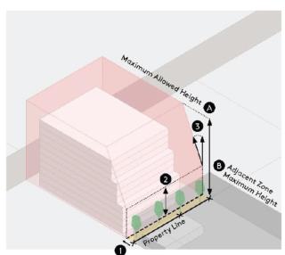
57.25.050 Transitions
1. General Provisions
a. Intent: Transitions are intended to ensure that new development is consistent with the vision of the NE 85th St. Station Area Plan to provide appropriate transitions of development intensity, height, and bulk between different zones.
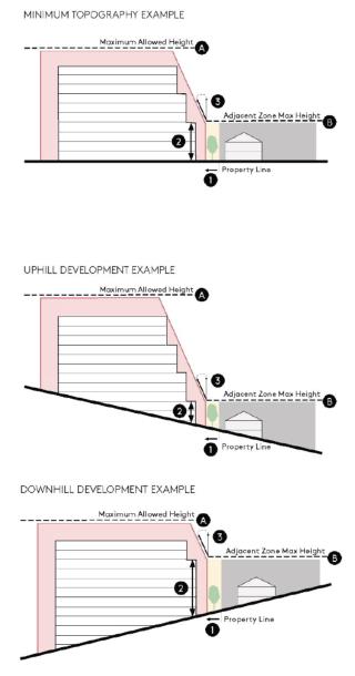
b. Applicability: Transitions are required where the difference between the maximum allowed height of a zoning district is at least 30 feet higher than the maximum allowed height of an adjacent zoning district. These transitions may be applied to side or rear lot lines. Front parcel transitions are addressed through upper story setbacks requirements for each regulating district. No portion of the structure shall extend into this sky plane exposure.
c. Transition Requirements: Where transitions are applicable, they shall consist of a required landscape buffer and a sky exposure plane.
d. Landscape Buffer: A minimum 15-foot-wide landscaped strip with a six-foot-high solid screening fence or wall planted consistent with Buffering Standard 1 of Chapter 95 KZC.
e. Sky Exposure Plane: Transitions are established using a sky exposure plane that sets the maximum envelope for massing within the subject property. The sky exposure plane is measured at an angle from a vertical line. To calculate the sky exposure plane, use the following steps:
1) Create a vertical plane set back 15 feet from and parallel to the common lot line.
2) Establish a maximum height of the vertical plane by determining the average elevation of the common property line between zoning districts, plus the maximum allowed height of the adjacent zone (see Figure 24).
3) From the top of this vertical plane, extend the required sky exposure plane angle 25 degrees to the maximum allowed height of the subject property. Where the maximum height between zoning districts is 50 feet or higher, extend the required sky exposure plane at an angle 30 degrees to the maximum allowed height of the subject property.
FIGURE 24: TRANSITION REQUIREMENT
|
|
|
|
||
|
TRANSITIONS |
|
|||
|
Applicability |
|
Transitions are required if the allowed maximum height for the subject parcel is greater than 30' above the maximum allowed height for any adjacent parcel. |
|
|
|
|
|
|||
|
Requirement |
➊ |
Create a vertical plane 15' set back from and parallel to the common lot line. |
|
|
|
➋ |
Establish a maximum height of the vertical plane by determining the average elevation of the common property line between zoning districts, plus the maximum allowed height of the adjacent for the zone of the adjoining property. |
|
||
|
➌ |
From the top of this vertical plane, extend the required sky exposure plane at an angle of 25 degrees to the maximum allowed height of the subject property. Where the maximum height between zoning districts is 50' or higher extend the required sky exposure plane at an angle 30 degrees to the maximum allowed height of the subject property. |
|
||
|
|
||||
57.25.060 Parking
1. General Provisions
a. Off-Street Parking
1) Required Parking: The following off-street parking requirements apply to uses in the regulating districts as shown in Table 6.
|
Land Use |
Minimum Required Parking Spaces |
|---|---|
|
Residential: Detached Dwelling Unit |
2/unit |
|
Residential: Residential Suites, Attached or Stacked Dwelling Units |
0/affordable studio unit or residential suite 0/affordable one-bedroom unit 0.75/studio unit or residential suitea 1/one-bedroom unit 1.25/two-bedroom unit 1.5/three- or more bedroom unit |
|
Residential: Assisted Living Facility |
0.5/unit |
|
Residential: Convalescent Center |
0.5/bed |
|
Commercial |
2/1,000 SF GFA |
|
Industrial |
1/1000 SF GFA Breweries, wineries or distilleries shall apply the minimum required industrial parking rate only for the portion of the building engaged in industrial uses. Tasting rooms for breweries, wineries, or distilleries shall provide parking at 2/1000 SF GFA. |
|
Institutional |
Set by the City Transportation Engineer under KZC 105.25 |
a) Market-rate residential suite parking may be reduced to 0.5/suite if the following transportation demand management strategies are implemented in addition to the required transportation demand management strategies identified in KZC 57.25.07:
(1) Provide a bus pass or equivalent alternative transportation mode subsidies for tenants who do not have cars.
(2) Include lease provisions and monitoring requirements for the property owner to ensure that tenants are not parking off site to avoid parking charges.
2) Shared Parking Reduction: Shared parking is allowed in accordance with the provisions in KZC 105.45.
3) Modification to Minimum Required Parking: For a modification to subsection (1)(a)(1) of this section, a decrease in the required number of spaces may be granted by the Planning Official if the number of spaces proposed is documented by an adequate and thorough parking demand and utilization study to be sufficient to fully serve the use. The study shall be prepared by a licensed transportation engineer or other qualified professional and shall analyze the operational characteristics of the proposed use which justify a parking reduction. The scope of the study shall be proposed by the applicant’s licensed transportation engineer or other qualified professional and approved by the City Transportation Engineer. The study shall provide at least two days of data for morning, afternoon and evening hours, or as otherwise approved or required by the City Transportation Engineer. Approval of a parking reduction shall be solely at the discretion of the City. A decrease in the minimum required number of spaces may be based in whole or part on the provision of nationally accepted TDM (Transportation Demand Management) measures. Data supporting the effectiveness of the TDM measures shall be provided as part of the parking demand and utilization study and approved by the City Transportation Engineer.
4) Parking Space Reductions Near Transit: For senior citizen households or housing units specifically for people with disabilities that are located within one-quarter mile of a transit stop that receives transit service at least four times per hour for 12 or more hours per day, minimum parking space requirements are eliminated for residents. Parking requirements for staff and visitors of such housing units will be established pursuant to KZC 105.25. The city will require an applicant to record a covenant that prohibits the rental or sale of a unit subject to this parking restriction for any purpose other than providing for senior citizen households or housing for people with disabilities.
5) Guest Parking: Refer to Chapter 105 KZC.
b. Parking Location: Refer to Chapter 105 KZC.
c. Parking Area Design: Refer to Chapter 105 KZC, as well as KZC 57.25.070, Sustainability Standards, for relevant requirements and incentives.
d. Parking Dimensional Standards: Refer to Chapter 105 KZC.
e. Bike Parking: Bicycle parking spaces shall be provided in all new development to encourage the use of bicycles as a form of transportation by providing safe and convenient places to park bicycles. Both short-term and long-term bicycle parking shall be provided. Short-term bicycle parking is intended to serve visitors or business patrons who visit the project site for a short time period, around four hours or less. Short-term bicycle parking is located near the site entrance in a visible location that makes it easy to find for visitors. Long-term bicycle parking is intended to serve residents or employees who may need to store bikes on site during a typical workday or overnight. Long-term bicycle parking is secured and weatherproof to provide a safe and comfortable storage place for longer periods.
1) General Bicycle Parking Standards
a) Short- and long-term bicycle parking shall be provided based on the following rates:
|
Use |
Short-Term Bicycle Parking Rate (spaces per suite/unit/bed or per sq. ft. of gross floor area) |
Long-Term Bicycle Parking Rate (spaces per suite/unit/bed or per sq. ft. of gross floor area) |
|---|---|---|
|
Residential: Detached Dwelling Unit |
Not required |
Not required |
|
Residential: Residential Suites, Attached or Stacked Dwelling Units |
0.05/suite or unit |
1/suite or unit |
|
Residential: Assisted Living Facility |
0.05/unit |
0.08/unit |
|
Residential: Convalescent Center |
0.05/bed |
0.08/bed |
|
Commercial: General |
0.50/1,000 SF GFA |
0.33/1,000 SF GFA |
|
Commercial: Office |
0.07/1,000 SF GFA |
0.33/1,000 SF GFA |
|
Industrial |
0.01/1,000 SF GFA Breweries, wineries or distilleries shall apply the minimum required industrial parking rate only for the portion of the building engaged in industrial uses. Tasting rooms for breweries, wineries, or distilleries shall provide parking at 0.50/1,000 SF GFA |
0.08/1,000 SF GFA Breweries, wineries or distilleries shall apply the minimum required industrial parking rate only for the portion of the building engaged in industrial uses. Tasting rooms for breweries, wineries, or distilleries shall provide parking at 0.33/1,000 SF GFA |
|
Institutional |
As determined by City Transportation Engineer under KZC 105.25 |
As determined by City Transportation Engineer under KZC 105.25 |
b) Commercial development, both general commercial and office uses, and institutional development required to provide 25 or more long-term bike parking spaces shall also provide at least one shower for commuters. Shower facilities shall be provided at a rate of one shower per 25 required long-term bike parking spaces. Showers should be provided adjacent to bike parking although showers provided on site as part of other facilities may satisfy this requirement; provided, that wayfinding signage is included.
c) The required number of short-term bicycle parking spaces shall be rounded up to the nearest even number.
d) The required number of long-term bicycle parking spaces shall be rounded up to the nearest whole number.
e) The Planning Official may modify the required amount of bicycle parking according to size of development and anticipated pedestrian and bicycle activity as determined by the City Transportation Engineer. Lack of existing bicycle and pedestrian activity shall not be considered as sufficient criteria to provide less than the minimum required amount of bicycle parking.
f) Design of bike parking is subject to approval by Public Works Official.
f. Loading and Driveways: Refer to KZC 115.47. Additionally, the following standards apply in the regulating districts:
1) Wherever practical, vehicular access for loading or parking should not be provided along the following street types: main street, major thoroughfare.
2) Refer to Public Works Policy R-4 for driveway location standards, subject to approval by the Public Works Official.
g. Special Regulations for Institutional Uses: For school and/or childcare uses greater than 5,000 GSF, an on-site passenger loading area must be provided, unless otherwise approved by the Public Works Official. The Public Works Official shall determine the appropriate size of the loading areas on a case-by-case basis, depending on the number of attendees and the extent of the abutting right-of-way improvements. Carpooling, staggered loading/unloading time, right-of-way improvements or other means may be required to reduce traffic impacts on the network.
57.25.070 Transportation Demand Management
1. Required Transportation Management Plan – All new commercial development and all new residential development greater than 15 units within the station area shall prepare and implement a transportation management plan that identifies their proposed transportation demand management strategies.
2. Transportation Management Plan Administration
a. Each transportation management plan (TMP) shall be in a form approved by the City and recorded with King County. The TMP shall acknowledge that it is a violation of the KZC to deviate from the required transportation demand management strategies.
b. Each development shall designate a transportation coordinator to manage the TMP, provide commute information to residents or employees, and be a point of contact for the City.
c. Each development shall participate in a biannual survey of residents in a form approved by the City to document transportation mode share, parking utilization, and potential spillover parking.
3. Required Transportation Demand Management Strategies
a. The costs to provide parking shall be unbundled from the rental costs.
b. New developments shall charge for off-street parking.
c. New developments shall monitor the demand for parking and manage the provided parking supply to reduce the risk of spillover parking.
d. New developments shall provide full transit pass subsidies for all employees.
e. New developments shall actively participate in City and development transportation demand management efforts by partnering on the development, distribution, and promotion of commuter marketing programs.
f. New developments shall provide an emergency ride home program for employees.
g. New developments shall provide bicycle parking and other facilities as required in KZC 57.25.060(1)(e).
h. New developments shall support carpooling by developing a ridematch program for employees.
57.25.080 Sustainability Standards
1. Relationship to Other Regulations – Reserved.
2. General Provisions
a. Intent: The sustainability standards code is intended to ensure that new development is consistent with the vision of the NE 85th St. Station Area Plan sustainability framework as well as aligned with the Sustainability Master Plan.
b. Requirements: As part of any development permit submittal, all projects shall complete a form provided by the City of Kirkland indicating their review of the NE 85th St. Station Area Plan Chapter 10.0, Sustainability Framework, and how the development is aligned with those goals and opportunities. All new developments and major renovations requiring Design Board Review per KZC 142.15 shall be designed, built, and certified to achieve or exceed requirements in three categories: High Performance Buildings; Energy and Decarbonization; and Ecosystems and Green Infrastructure.
1) High Performance Buildings – All new developments and major renovations shall be designed, built, and certified to achieve or exceed the high performance building standards described in KZC 115.62 to the extent those standards are consistent with State and Federal mandated requirements. For commercial developments that are building core and shell only, they may be designed, built, and certified to achieve LEED v4 Core and Shell Gold as an alternative certification to meet requirements of KZC 115.62(2)(b). Some third-party protocol certifications may be eligible for the incentive program; refer to KZC 57.30.
2) Energy and Decarbonization
a) All new developments larger than 5,000 square feet shall include a renewable energy generation system with production at a rate of 0.60 W/sf of all conditioned area. Renewable energy shall be produced on site, or off site including the following compliance options in 2021 Washington State Energy Code Section C411.2.1.
b) All new developments and major renovations less than 20 stories shall include solar readiness, per 2021 Washington State Energy Code standards, Section C411.3.
3) Ecosystems and Green Infrastructure
a) All new developments and major renovations shall be designed, built, and certified to achieve or exceed a green factor score of 0.4.
The green factor sets criteria for landscape and site-based sustainability measures. The landscape elements listed will contribute to larger district sustainability goals focused on the natural environment, ecosystems, and stormwater. The elements that contribute more significantly to supporting the Citywide Sustainability Master Plan’s goals related to sustainable urban waterways, conservation and stewardship, access to parks and open space, and sustainable urban forestry have been weighted higher in this green factor.
FIGURE 25: GREEN FACTOR CRITERIA
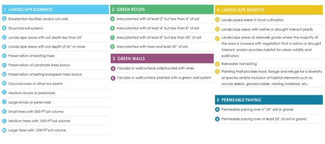
3. Green Factor – The green factor score shall be calculated as follows:
a. Identify all proposed elements in Table 8.
b. Multiply the square feet, or equivalent unit of measurement where applicable, of each landscape element by the multiplier provided for that element in Table 8 according to the following provisions:
1) If multiple elements listed in Table 8 occupy the same physical area, they may all be counted.
2) Landscaping elements and other frontage improvements in the right-of-way between the lot line and the roadway may only be counted if the enhancements in the right-of-way contribute to district sustainability goals including habitat connectivity, tree canopy, or stormwater goals and a commitment is made to ongoing maintenance and management of the landscape areas. Subject to approval by the City of Kirkland.
3) Unless otherwise noted, elements shall be measured in square feet.
4) For trees, large and medium shrubs and perennials, use the equivalent square footage of each tree or shrub provided in Table 8.
5) For green wall systems, use the square footage of the portion of the wall that will be covered by vegetation at three years. Green wall systems shall include year-round irrigation and a submitted maintenance plan shall be included as an element in the calculation for a project’s green factor score.
6) All vegetated structures, including fences counted as vegetated walls shall be constructed of durable materials, provide adequate planting area for plant health, and provide appropriate surfaces or structures that enable plant coverage. Vegetated walls shall include year-round irrigation and a submitted maintenance plan shall be included as an element in the calculation for a project’s green factor score.
7) For all elements other than trees, large shrubs, large perennials, green walls, structural soil systems and soil cell system volume; square footage is determined by the area of the portion of the horizontal plane that lies over or under the element.
8) All permeable paving and structural soil credits may not count for more than one-third of a project’s green factor score.
9) An innovation credit may be awarded at the discretion of the Planning Official. This credit can be awarded if a development seeks to exceed the minimum requirements in supporting larger district sustainability goals. The multiplier may range from 0.2 to 0.5 depending on the development proposal.
c. Add together all the products calculated in Table 8 to determine the green factor numerator.
d. Divide the green factor numerator by the parcel area to determine the green factor score. A development shall achieve a minimum score of 0.4.
e. The City of Kirkland reviewer has the final authority in determining the accuracy of the calculation of the green factor score.
|
1. Landscape Elements |
Multiplier |
|
|
A. |
Bioretention facilities and/or soil cells |
1.5 |
|
B. |
*Structural soil systems |
0.2 |
|
C. |
Landscaped areas with soil depth less than 24" |
0.1 |
|
D. |
Landscaped areas with soil depth of 24" or more |
0.6 |
|
E. |
Preservation of existing trees – calculated at 20 sq. ft. per inch dbh (Trees must have a minimum diameter of 6" at dbh.) |
1.0 |
|
F. |
Preservation of Landmark Trees bonus – calculated at 20 sq. ft. per inch dbh (Trees must meet City of Kirkland’s definition of “landmark trees”) |
0.1 |
|
G. |
Preservation of existing evergreen trees bonus – calculated at 20 sq. ft. per inch dbh (Preserved evergreen trees must have a minimum diameter of 6" at dbh) |
0.1 |
|
H. |
Ground covers or other low plants (less than or equal to 2' tall at maturity) |
0.1 |
|
I. |
Medium shrubs or perennials – calculated at 9 sq. ft. per plant (2'-4' tall at maturity) |
0.3 |
|
J. |
Large shrubs or perennials – calculated at 36 sq. ft. per plant (greater than 4' tall at maturity) |
0.4 |
|
K. |
**Small trees or equivalent with calculated soil volume that meets or exceeds 500 ft3 per tree – calculated at 90 sq. ft. per tree (canopy spread 10' to 15' at maturity) |
0.3 |
|
L. |
**Medium trees or equivalent with calculated soil volume that meets or exceeds 1,000 ft3 per tree – calculated at 230 sq. ft. per tree (canopy spread 16' to 24' at maturity) |
0.5 |
|
M. |
**Large trees with calculated soil volume that meets or exceeds 1,500 ft3 per tree – calculated at 350 sq. ft. per tree (canopy spread 25' and greater at maturity) |
0.7 |
|
2. Green Roofs |
||
|
A. |
Area planted with at least 2" of growth medium but less than 4" of soil |
0.4 |
|
B. |
Area planted with at least 4" but less than 8" of soil |
0.7 |
|
C. |
Area planted with at least 8" of but less than 30" of soil |
1.0 |
|
D. |
Area planted with tree(s) and at least 30" of soil |
1.5 |
|
3. Green Walls |
||
|
A. |
Facade or wall surface obstructed with vines (calculate at 3 years of growth) |
0.1 |
|
B. |
Facade or wall surface planted with a green wall system (must have year-round irrigation and maintenance plan) |
0.2 |
|
4. Landscape Benefits |
||
|
A. |
***Landscaped areas in food cultivation |
0.2 |
|
B. |
Landscaped areas planted with native or drought tolerant plants |
0.1 |
|
C. |
Landscaped areas at sidewalk grade where the majority of the area is covered with vegetation that is native or drought tolerant, and/or provides habitat for urban wildlife and pollinators |
0.1 |
|
D. |
Landscaped areas where at least 50% of annual irrigation needs are met through the use of harvested rainwater |
0.2 |
|
E. |
****Planting that provides food, forage and refuge for a diversity of species (native insects, pollinators, birds, and other urban wildlife) and/or inclusion of habitat elements such as woody debris, gravel/cobble, nesting materials, etc. |
0.2 |
|
5. Permeable Paving |
Multiplier |
|
|
A. |
Permeable paving over a minimum 6" and less than 24" of soil or gravel |
0.2 |
|
B. |
Permeable paving over at least 24" of soil or gravel |
0.5 |
|
6. Innovation |
||
|
A. |
Contributes to district sustainability goals including habitat connectivity, tree canopy, or stormwater goals beyond the site boundary (i.e., treating stormwater from public ROW on project site, daylighting piped streams, enhanced tree canopy and habitat connecting larger patches/corridors, enhance and maintain landscaping in ROW, enhanced stormwater treatment for water quality pollutants including metals, 6PPD Quinone, and phosphorus, landscape plan that demonstrates a commitment to minimal pesticide and fertilizer inputs, adaptive management plans). Scoring to be awarded at the discretion of the City of Kirkland. |
0.2-0.5 |
* Structural soil system means a soil mix or equivalent structure that is engineered to support pavement while allowing healthy root growth.
** For purposes of determining the size category of a tree species, the tree must have a mature canopy spread of the following:
Small Trees – 8 feet to 16 feet
Medium Trees – 16 feet to 26 feet
Large Trees – 26 feet or more
*** Landscape areas in food cultivation are defined as a use in which land is used to grow plants and harvest food or ornamental crops for donation or for use by those cultivating the land and their households. Examples include Pea Patch community gardens.
**** Refer to the Green Factor Scoresheet Reference Pollinator Plant List tab and City Pollinator Plant List for reference plant species.
(Ord. 4855 § 1, 2023; Ord. 4802 § 1, 2022)
57.30 Incentive Zoning Program
57.30.010 Purpose
The purpose of the incentive zoning program within the subarea is to provide additional development capacity for commercial uses above the allowed base height zoning in exchange for providing amenities with a clear public benefit while addressing the impacts that this additional development might have on the community. This incentive zoning program is to be used in conjunction with the affordable housing requirements for residential uses in the Station Area pursuant to Chapter 112 KZC.
57.30.020 General Provisions
The incentive zoning program may be utilized to achieve development of commercial uses up to the bonus maximum allowed height where the regulating district map (Fig. 2 of this chapter) identifies both a base and maximum allowed height (e.g., CMU 85'/150'). Where a regulating district identifies only a base maximum height, that property is not eligible to receive incentive development capacity (e.g., CMU 60). In no case may the incentive zoning allow development that exceeds the maximum building height as allowed in Figure 2. Requirements for residential uses to achieve the bonus maximum allowed height are set forth in Chapter 112 KZC.
57.30.030 Required Review
The Planning and Building Director may approve an application for incentive zoning that complies with Table 9 if the Director finds that:
1. The design and/or extent of the amenity meets the standards established in Table 9 and Table 10 criteria; and
2. Where amenities are to be provided on the subject property, the public benefits provided, described in Table 9 for each amenity type, will be derived from the development of the proposed amenity in the proposed location.
3. Covenants, easements, and agreements are established to ensure the provision of the proposed amenities in perpetuity.
An application for incentive zoning shall be made on the forms provided by the City and submitted with the established application fee.
An applicant may propose flexible amenity options as identified in Table 9 through a development agreement subject to the provisions of KZC 57.05.030; provided, that the City finds that the flexible amenity options clearly meet or exceed the public benefit that would result from the standard incentive amenities.
57.30.040 Incentive Amenities and Exchange Rates for Incentive Capacity
Tables 9 and 10 describe the incentive amenities that may be provided to receive commercial incentive capacity and the exchange rate at which commercial incentive capacity will be granted for each unit of amenity provided. Measurements shall be in square feet (indicated as “sf” in tables).
1. Provided Amenity Structure
a. An applicant must provide incentive amenities from at least two different categories in Table 9 in order to receive incentive capacity. No more than 75 percent of the requested incentive capacity may be achieved through provision of amenities in a single category. Applicants may choose to provide amenities from more than two amenity categories.
b. Modification of Amenity Structure Requirements. The Planning and Building Director may grant a modification to allow an applicant to achieve more than 75 percent of their incentive capacity through provision of amenities from a single category in instances where it is determined the proposed amenity structure:
1) Provides an exceptional community benefit in the chosen amenity category such that the benefit is demonstrably superior to what could be provided through the required diversification of amenities; or
2) The subject property has a unique condition that precludes the ability to provide the diversity of amenities.
|
Proposed List of Eligible Amenities |
Public Benefit Provided |
|---|---|
|
AFFORDABLE HOUSING |
|
|
Commercial Development: Affordable housing contribution (fee-in-lieu) |
Fee revenue for affordable housing |
|
MOBILITY/TRANSPORTATION |
|
|
Enhanced Mid-Block Green Connections: Enhancement to an active transportation connection through a property that provides a route alternative to the vehicular road network, established through either a public easement or a right-of-way dedication. |
Square feet of enhanced mid-block green connections |
|
PARKS/OPEN SPACE |
|
|
Public Open Space (outdoor): Outdoor spaces available for public use such as plazas, pocket parks, linear parks, rooftops, etc. |
Square feet of improved public outdoor park-like space |
|
Public Community Space (indoor): Spaces available for civic or community uses such as arts or performance spaces, after-school programming, recreation, event space, etc. |
Square feet of improved public indoor community space |
|
SUSTAINABILITY |
|
|
Enhanced Performance Buildings: Design, build and certify to achieve Living Building Challenge v4 Carbon Certification or Living Building Challenge v4 Petal Certification |
New buildings that exceed Kirkland High Performance Building Code |
|
Ecology and Habitat: Achieve a Green Factor Score of at least 0.75 – (as-of-right requires projects to demonstrate a score of at least 0.4) |
SF of land, enhanced ecology/habitat |
|
Innovation Investments: Design, build and operate innovative energy and/or decarbonization systems (on site or within SAP) |
New and innovative sustainability infrastructure in the Station Area |
|
SCHOOLS, EDUCATION, AND CHILDCARE |
|
|
ECE/Day Care Operation Space: Floor area dedicated to childcare, or preschool learning space, as defined in KZC 5.10.194 Design Criteria: 1. Bonus preschool space must provide a minimum of 4 classrooms, with a minimum of 900 SF per classroom. 2. Space shall be used in the manner described for the life of the project. 3. Documentation of required licensing for day care operation shall be provided. |
Long-term dedication of building space for non-profit childcare use |
|
School Operation Space: Floor area dedicated to school operation as defined in KZC 5.10.825 Design Criteria: 1. Bonus school space must provide a minimum of 4 classrooms, with a minimum of 900 SF per classroom. 2. Space shall be used in the manner described for the life of the project. 3. Documentation of required licensing for school operation shall be provided. |
Long-term dedication of building space for education use |
|
GROCERY STORE |
|
|
Grocery Store: Floor area of at least 20,000 SF dedicated to a full-service grocery store. This amenity may only be used to achieve incentive capacity when there are no other grocery stores within one-half mile of the proposed location. |
Long-term dedication of building space for neighborhood grocery use |
|
OTHER APPLICANT PROPOSED AMENITIES |
|
|
Flexible Amenity Options: Applicant may propose amenities not on this list (on a case-by-case basis). Amenities must have a clear public benefit and will be subject to approval by the City and formalized in a development agreement. |
TBD |
|
List of Eligible Amenities |
Measure of Exchange Rate |
Policy Weighted Bonus Ratio |
Amenity Provided per 20,000 sf of IZ bonus space |
||
|---|---|---|---|---|---|
|
Priority Rank |
Priority Weight |
Bonus Ratio (priority) |
Bonus Ratio (priority) |
||
|
AFFORDABLE HOUSING |
|||||
|
Commercial Development Contribution |
Voluntary fee per SF of incentive bonus space |
1 |
1.50 |
$16.67 |
$333,333 |
|
MOBILITY/TRANSPORTATION |
|||||
|
Enhanced Mid-Block Green Connections |
Bonus SF per SF of enhanced connections |
3 |
1.00 |
5.0 |
4,000 sf |
|
PARKS/OPEN SPACE |
|||||
|
Public Open Space (outdoor) |
Bonus SF for each SF of improved public space |
2 |
1.25 |
7.5 |
2,667 sf |
|
Public Community Space (indoor) |
Bonus SF for each SF of improved public space |
2 |
1.25 |
8.8 |
2,286 sf |
|
SUSTAINABILITY |
|||||
|
Enhanced Performance Buildings |
Bonus SF per $1,000 invested |
3 |
1.00 |
40.0 |
$500,000 |
|
Ecology and Habitat (GF score above 0.75) |
Bonus SF for each SF of enhanced ecology/habitat land |
3 |
1.00 |
1.4 |
14,286 sf |
|
Innovation Investments: Energy and Decarbonization |
Bonus SF per $1,000 invested |
3 |
1.00 |
40.0 |
$500,000 |
|
SCHOOLs, EDUCATION, AND CHILDCARE |
|||||
|
ECE/Day Care Operation Space |
Bonus SF for each SF of ECE/Day Care space |
2 |
1.25 |
12.5 |
1,600 sf |
|
School Operation Space |
Bonus SF for each SF of school space |
2 |
1.25 |
12.5 |
1,600 sf |
|
GROCERY STORES |
|||||
|
Grocery Store Space |
Bonus SF for each SF of grocery space |
3 |
1.00 |
40.0 |
4,000 sf |
|
OTHER APPLICANT PROPOSED AMENITIES |
|||||
|
Flexible Amenity Options |
TBD |
3 |
1.00 |
40.0 |
$500,000 |
(Ord. 4855 § 1, 2023; Ord. 4802 § 1, 2022)