


Chapter 19.05
CRITICAL AREAS
Sections:
19.05.070 Critical area 1 – Aquifer recharge areas.
19.05.080 Critical area 2 – Fish and wildlife habitat conservation areas.
19.05.090 Critical area 3 – Frequently flooded areas and critical drainage corridors.
19.05.100 Critical area 4 – Geologically hazardous areas.
19.05.110 Critical area 5 – Wetlands.
19.05.120 Violations and penalties.
19.05.130 Bonding and security.
19.05.140 Other laws and regulations.
19.05.150 Suspension – Revocation.
19.05.190 Limitation of actions.
19.05.010 Purpose.
The Washington Growth Management Act (GMA) requires that critical areas within the city are to be protected by establishing protection standards for minimizing the impact of development of properties within critical areas consistent with best available science. The goal of this chapter is to protect and improve the city of Port Townsend’s critical areas for the present and future generations.
Critical areas provide a variety of valuable biological and physical functions that benefit the city of Port Townsend and its residents, and/or may pose a threat to human safety or to public or private property. Managing critical areas is also key to improving the city’s resiliency in light of anticipated climate change. Critical areas include wetlands; critical aquifer recharge areas; fish and wildlife habitat conservation areas; frequently flooded areas; critical drainage corridors; and geologically hazardous areas. These are termed “critical areas,” which also include their protective buffers, and are of special concern to the city and the citizens of the state. This chapter addresses only the city’s critical areas – city council has determined that the city will not designate any natural resource lands as defined by the Growth Management Act. It is the intent of this chapter to protect the public health, safety, and welfare by:
A. Reducing the potential for personal injury, loss of life or property damage due to flooding, erosion, landslides, seismic events or soil subsidence;
B. Achieve no net loss of critical areas functions and values through avoidance or mitigation sequencing to mitigate critical area impacts:
1. Avoiding the impact altogether by not taking a certain action or parts of an action;
2. Minimizing impacts by limiting the degree or magnitude of the action and its implementation, by using appropriate technology, or by taking affirmative steps to avoid or reduce impacts;
3. Rectifying the impact by repairing, rehabilitating, or restoring the affected environment;
4. Reducing or eliminating the impact over time by preservation and maintenance operations during the life of the action;
5. Compensating for the impact by replacing, enhancing, or providing substitute resources or environments; and/or
6. Monitoring the impact and taking appropriate corrective measures;
C. Protecting against publicly financed expenditures as a result of the misuse of critical areas when that misuse causes on-site or off-site:
1. Unnecessary maintenance and replacement of public facilities;
2. Mitigation for avoidable impacts;
3. Cost for public emergency rescue and relief operations where the causes are avoidable;
4. Degradation of the natural environment;
D. Maintaining healthy, functioning ecosystems through the protection of unique, fragile and valuable elements of the environment, including ground and surface waters, wetlands, fish and wildlife, and their habitats;
E. Alerting appraisers, assessors, owners, potential buyers or lessees to the development limitations of critical areas;
F. Providing city officials with sufficient information to adequately protect critical areas when approving, conditioning or denying public or private development proposals;
G. Implementing the policies of the State Environmental Policy Act, the State Growth Management Act, this code, and the city Comprehensive Plan. (Ord. 3348 § 3 (Exh. A), 2025; Ord. 3198 § 3 (Exh. A), 2018; Ord. 2899 § 1, 2005; Ord. 2319 § 1, 1992).
19.05.020 Definitions.
For the purposes of this chapter, the following definitions shall apply:
“Abutting” means having a common border with or being separated from such common border by a public right-of-way. See also “Contiguous.”
“Alteration” means, with respect to critical areas, any human-induced change in an existing condition of a critical area or its buffer. Alteration includes, but is not limited to:
1. Grading, filling, dredging, draining, channelizing, cutting, topping;
2. Clearing, relocating or removing vegetation;
3. Paving, construction, including construction of surface water management facilities;
4. Storage of equipment and materials; or
5. Human activity that impacts the existing topography, vegetation, hydrology, water quality, or wildlife habitat.
Alteration does not include interior building improvements or walking, passive recreation or similar activities.
“Applicant” means a person who files an application for a development permit under this code and who is either the owner of the land on which that proposed activity would be located, a contract vendee, a lessee of the land, the person who would actually control and direct the proposed activity, or the authorized agent of such a person.
“Aquifer recharge area” means geological and soil formations with recharging areas having an effect on aquifers used for potable water where a potential source of drinking and ground water is vulnerable to contamination.
“Base flood” means a flood event having a one percent chance of being equaled or exceeded in any given year (also referred to as the 100-year flood). The area subject to the base flood is the special flood hazard area designated on flood insurance rate maps as zone “A” or “V” including AE, AO, AH, A1-99 and VE. See “Frequently flooded areas.”
“Best available science” means current scientific information used in the process to designate, protect or restore critical areas that is derived from a valid scientific process which meets the criteria in WAC 365-195-900 through 365-195-925.
“Best management practices (BMPs)” means conservation practices or systems of practices and management measures that:
1. Avoid or control soil loss and protect water quality from degradation caused by nutrients, animal waste, toxins and sediment; and
2. Avoid or minimize adverse impacts to surface water and ground water flow, and circulation patterns; and
3. Avoid or control the movement of sediment and erosion control caused by land alteration activities; and
4. Avoid or minimize adverse impacts to the chemical, physical, and biological characteristics of critical areas.
BMPs are those practices as defined by the State of Washington Department of Agriculture, Washington State Department of Ecology, Washington State Department of Health, Washington State Department of Fish and Wildlife, Jefferson County conservation district, and other professional organizations. Applicable BMPs may be more fully identified in the city’s engineering design standards (EDS) and procedures manual to be adopted by the director.
“Buffer” means an area that protects a critical area which is required for the continued maintenance, functioning, and/or structural stability of a critical area.
“Building pad” means a portion of a lot which has been altered or designated to provide an acceptable location for a structure. This area is determined by criteria set forth in PTMC 19.05.060.
“Case-by-case” means decisions that are made separately, each according to the facts of the particular situation including but not limited to site conditions and intensity of the proposed activity.
“Classified species” means endangered, threatened or priority species as defined by the State Department of Fish and Wildlife.
“Compensatory mitigation” means replacing or rectifying a critical area impact or buffer loss. For purposes of wetland compensatory mitigation, the Army Corps of Engineers order of preference for mitigation methods is:
1. Re-establishment: The manipulation of the physical, chemical, or biological characteristics of a site with the goal of returning natural/historic functions and environmental processes to a former wetland. Re-establishment results in rebuilding a former wetland and results in a gain in wetland area and functions. Example activities could include removing fill, plugging ditches, or breaking drain tiles to restore a wetland hydroperiod, which in turn will lead to restoring wetland biotic communities and environmental processes.
2. Rehabilitation: The manipulation of the physical, chemical, or biological characteristics of a site with the goal of repairing natural/historic functions and environmental processes to a degraded wetland. Rehabilitation results in a gain in wetland function but does not result in a gain in wetland area. The area already meets wetland criteria, but hydrological processes have been altered. Rehabilitation involves restoring historic hydrologic processes.
3. Establishment (Creation): The manipulation of the physical, chemical, or biological characteristics of a site to develop a wetland on an upland where a wetland did not previously exist at an upland site.
4. Preservation: The removal of a threat to, or preventing the decline of, wetlands by an action in or near those wetlands.
5. Enhancement: The manipulation of the physical, chemical, or biological characteristics of a wetland to heighten, intensify, or improve specific wetland function(s).
“Contiguous” means having a common border with, but not separated from such common border by, a public right-of-way. See also “Abutting.”
Critical Areas. For the purposes of this chapter, “critical areas” means the following areas of the city: aquifer recharge areas, fish and wildlife habitat conservation areas, frequently flooded areas and critical drainage corridors or areas, geologically hazardous areas, wetlands and streams.
“Critical drainage corridor” or “area” means an area identified in the drainage system hierarchy tier of the city’s stormwater management plan. Critical drainage corridors may be waters of the U.S. or state, and mitigate flooding, drainage, erosion or sedimentation problems that have resulted or may result from the cumulative impacts of development and urbanization.
“Critical facility” means a facility for which even a slight chance of damage because of an incident occurring within a hazard area would be too great. Critical facilities include, but are not limited to, schools, hospitals, police, fire and emergency response installations. A critical facility may be a high risk use regulated in aquifer recharge areas, but not all high risk uses are critical facilities.
“Critical habitat” means areas associated with endangered, threatened or priority species as defined by the State Department of Fish and Wildlife. Such habitat areas are documented with reference to lists, categories, and definitions of species promulgated by the Washington State Department of Fish and Wildlife or by regulations adopted currently or thereafter by the U.S. Fish and Wildlife Service.
“Critical slope” means any area with slopes of 40 percent or steeper that exceed a vertical height of 10 feet. A critical slope is determined by measuring the vertical rise over any 25-foot horizontal run for a specific area that results in a percentage of 40 or more. The critical slope hazard area includes the area of land that extends for 10 feet from the top and toe of the slope.
“Cumulative adverse impact” is the impact on the environment that results from the incremental impact of the action when added to other past, present and reasonably foreseeable future actions regardless of who undertakes such other actions. Cumulative impacts can result from individually minor but collectively significant actions taking place over time.
“Delineation” means a process used to locate and mark a critical area’s edge or boundary in the field. Wetland delineations are valid for a period of five years.
“Development” or “development proposal” means any land use or development permit that authorizes activity upon the land or binds land to a specific development pattern including but not limited to a building permit, clearing and grading permit, rezone, conditional use permit, variance, lot line revision, PUD, short and long subdivision, street and utility development permit, or any development subject to stormwater drainage requirements under PTMC Title 13. “Development proposal” does not include permit approvals for interior alterations. See also “Alteration” in this section.
“Diameter at breast height (d.b.h.)” means a tree’s trunk diameter in inches measured four and one-half feet above the ground.
1. On multistemmed or trunked trees, where the diameter at four and one-half feet above grade is actually greater than at a lower point on the tree, d.b.h. shall be measured at the narrowest diameter below four and one-half feet. In such cases the height of the measurement should be noted.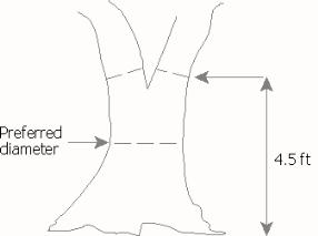
Illustration 1a – Multitrunked Tree
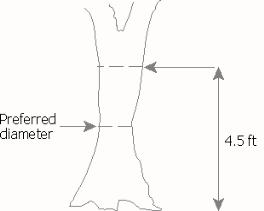
Illustration 1b – Multitrunked Tree
2. On sloping ground, diameter shall be measured from the uphill side of the tree.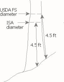
Illustration 2a – Tree on
Sloping Ground
3. On leaning trees, diameter shall be measured four and one-half feet up the stem in the direction of the lean.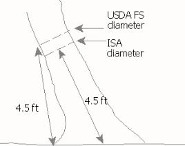
Illustration 3a – Leaning Tree
4. On multitrunked trees, where tree splits into several trunks close to ground level, the diameter shall be the diameter equivalent to the sum of each individual trunk measured according to the principles listed above. 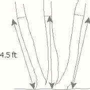
Illustration 4a – Multitrunk Tree,
Close to Ground
“Director” refers to the director of the city development services department and his/her designees.
“Endangered species” means any species that is in danger of extinction throughout all or a significant portion of its range.
“Erosion hazard area” means those areas containing soils that, according to the USDA National Resource Conservation Service, have a “severe” rill and inter-rill erosion hazard.
“Exotic species” means plants or animals that are not native to the Olympic Peninsula region.
“Feeder bluff” means an eroding coastal bluff that delivers a significant amount of sediment to the beach over an extended period of time and contributes to the local littoral sediment budget. Feeder bluffs subject to wave action are also categorized as “marine bluffs.”
“Fish and wildlife habitat conservation areas” means land management for maintaining populations of species in suitable habitats within their natural geographic distribution so that the habitat available is sufficient to support viable populations over the long term and isolated subpopulations are not created. This does not mean maintaining all individuals of all species at all times, but it does mean not degrading or reducing populations or habitats so that they are no longer viable over the long term. Counties and cities should engage in cooperative planning and coordination to help assure long-term population viability. These areas include, but are not limited to, a seasonal range or habitat element with which a classified species has a primary association, and which, if altered, may reduce the likelihood that the species will maintain population levels and reproduce over the long term. These may include areas of relative density or species richness, flyways, breeding habitat, winter range, migratory routes and wildlife movement corridors. Fish and wildlife habitat conservation areas do not include such artificial features or constructs as irrigation delivery systems, irrigation infrastructure, irrigation canals, or drainage ditches that lie within the boundaries of and are maintained by a port district or an irrigation district or company.
“Frequently flooded areas” means lands subject to a one percent or greater chance of flooding in any given year or areas mapped as such by the Federal Emergency Management Agency or the National Flood Insurance Program, or areas identified by the public works department through basin studies and hydraulic analysis.
“Functions” means the products, physical and biological conditions, and environmental qualities of a critical area that result from interactions among ecosystem processes and structures. Ecosystem functions include, but are not limited to, water quality protection; flood storage, conveyance, and attenuation; wave attenuation; ground water recharge and discharge; carbon sequestration; water temperature modification; and fish and wildlife habitats.
“Geologically hazardous areas,” as referred to in WAC 365-190-120, means lands susceptible to erosion, sliding or other potentially hazardous geological events. They include erosion hazard areas, landslide hazard areas, seismic hazard areas and tsunami hazard areas.
Geotechnical Engineer. See “Qualified consultant.”
“Hazard tree (danger tree)” means a tree that is a threat to life, property, or public safety, as determined by a qualified arborist.
“Hydric soils” means those soils that are saturated, flooded or ponded long enough during the growing season to create anaerobic conditions, thereby influencing the growth of plants. The presence of hydric soil shall be determined following the criteria and methods described in the approved federal wetland delineation manual and applicable regional supplements.
“Hydrophytic vegetation” means plant life growing in water or soil that is at least periodically deficient in oxygen as a result of excessive water content.
“Impervious surfaces” means areas or surfaces that cannot be easily penetrated by rain or surface water runoff. These areas include structures and roof projections, impervious decks/patios, roads, driveways, and other surfaces which similarly impede the natural infiltration of stormwater.
“In-kind compensation” means to mitigate critical area impacts with a substitute which provides characteristics and functions closely approximating those destroyed or degraded by a regulated activity. It does not mean replacement “in-category.”
“Infill development” means the development of a vacant or underutilized parcel or parcels that are similar in size and configuration to those found in the surrounding developed area. Infill development minimizes the need for new utilities and streets and supports the more efficient delivery of urban services through compact development patterns.
“Inland bank” means landslide or erosion hazard areas that are not subject to wave action. See “Marine bluff.”
“Land area” means the total horizontal area within the boundary lines of a lot less areas waterward of the ordinary high water mark, confirmed landslide hazard areas (PTMC 19.05.100(C)(2)), and wetlands. For example, only the buildable area landward of the marine bluff edge shall be used in calculating impervious surface limits.
“Landslide hazard areas” means those areas potentially subject to risk of mass movement due to a combination of geologic, topographic and hydrologic factors, including historic slope failures. These areas may be identified in the Port Townsend Comprehensive Plan, U.S. Geological Service Maps, the Department of Ecology Coastal Zone Atlas, or through site specific indicators or conditions.
“Low Impact Development Technical Guidance Manual for Puget Sound (LID Manual)” means the manual developed by the Puget Sound Action Team that describes environmentally friendly techniques to develop land and manage stormwater runoff.
“Marine bluff” means steep slopes affected by wind and wave action. Excluded from this definition are steep slopes that have been significantly removed from wave action due to the evolution of spits, lagoons, and protected marshes (e.g., bluffs along Washington Street downtown and above the campground at Fort Worden) or due to intervening, legal nonconforming development that eliminates wave action (e.g., bluffs behind Water Street between the Washington State Ferry terminal and Kearny Street). See “Inland bank”; “Feeder bluff.”
“Mitigation” means a process used to reduce the severity of impacts from activities that potentially affect critical areas. Mitigation, in the following sequential order of preference, is by the following means:
1. Avoiding the impact altogether by not taking a certain action or parts of an action;
2. Minimizing impacts by limiting the degree or magnitude of the action and its implementation, by using appropriate technology, or by taking affirmative steps;
3. Rectifying the impact by repairing, rehabilitating, or restoring the affected environment;
4. Reducing or eliminating the impact over time by preservation and maintenance operations during the life of the action;
5. Compensating for the impact by replacing, enhancing, or providing substitute resources or environments; and/or
6. Monitoring the impact and taking appropriate corrective measures.
Mitigation for individual actions may include a combination of the above measures.
“Native vegetation” means plant species which are indigenous to the Olympic Peninsula.
“No net loss” refers to the actions taken to achieve and ensure no overall reduction in existing ecosystem functions and values or the natural systems constituting the protected critical areas.
“Nonconforming structure or improvements” means, for the purposes of this chapter, legally established structures and improvements that do not meet the setback or buffer requirements of this chapter for any defined critical area.
“Noxious weed” means any plant which is invasive – for example, nonnative blackberries – and listed on the State Noxious Weed List in Chapter 16-750 WAC.
“Off-site compensation” means compensatory mitigation occurring on a site other than the site on which the impacts were located.
“On-site compensation” means compensatory mitigation on the site on which the impacts were located.
“Out-of-kind compensation” means compensatory mitigation achieved by creating substitute critical areas whose characteristics do not closely approximate those destroyed or degraded by a development activity.
“Peer review” means a review of a submitted critical areas report by an agency with expertise or a second practicing, licensed professional not associated with the original submittal selected and retained by the city. The peer review must verify the adequacy of the information, the adequacy of the analysis, and the completeness of the original checklist.
“Petroleum product” means petroleum and petroleum-based substances comprised of a complex blend of hydrocarbons derived from crude oil through processes of separation, conversion, upgrading and finishing, such as motor fuels, jet fuels, distillate fuel oils, residual fuel oils, lubricants, petroleum solvents, and used oils. The term “petroleum product” for the purposes of this chapter does not include propane or asphalt or any other petroleum product which is not liquid at standard conditions of temperature and pressure.
“Planning and community development department,” or “PCD,” means the city of Port Townsend planning and community development department.
“Practicable alternative” means an alternative available and capable of being carried out after taking into consideration cost, existing technology, and logistics in light of overall project purposes, and having less impacts to critical areas. It may include using an area not owned by the applicant which can reasonably be obtained, utilized, expanded or managed in order to fulfill the basic purpose of the proposed development.
“Procedures manual” means a document that may be prepared by the director, which outlines the process for determining whether critical areas are present on a lot as well as specific application and procedural details for permitting, site development and other requirements as described in this chapter.
“Qualified consultant” means a person with experience and training in the pertinent scientific discipline, and who is a qualified scientific expert with expertise appropriate for the relevant critical area subject in accordance with WAC 365-195-905. A qualified consultant must have obtained a B.S. or B.A. or equivalent degree in biology, engineering, environmental studies, fisheries, geomorphology, or related field, and have at least two years of related work experience.
1. For wetlands, a qualified consultant meets the following:
a. A Bachelor of Science or Bachelor of Arts or equivalent degree in hydrology, soil science, botany, ecology, resource management, or related field, or four years of full-time work experience as a wetland professional may substitute for a degree; and
b. At least two additional years of full-time work experience as a wetland professional, including delineating wetlands, preparing wetland reports, conducting function assessments, and developing and implementing mitigation plans; and
c. Completion of additional wetland-specific training programs. This could include a more comprehensive program such as the University of Washington Wetland Science and Management Certificate Program or individual workshops on topics such as wetland delineation, function assessment, mitigation design, hydrophytic plant or hydric soil identification.
2. For habitat, a qualified consultant must have a degree in biology or a related degree and professional experience related to the subject species.
3. For geologically hazardous areas, a qualified consultant means:
a. An engineering geologist, with a Washington specialty license in engineering geology (LEG). A LEG is qualified to provide a study including interpretation, evaluation, analysis, and application of geological information and data to predict potential or likely changes in types and rates of surficial geologic processes due to proposed changes to a location. For marine shorelines west of Point Wilson on the Strait of Juan de Fuca, the LEG shall have at least three documented projects involving coastal processes including open ocean swell. A LEG may recommend mitigation measures that do not require engineering (e.g., appropriate buffers, landscaping); and where necessary;
b. An engineer with a valid Washington State engineering license as specified in Chapter 18.43 RCW. Where mitigation measures require engineering, the geotechnical report must be co-sealed by an engineer who has a valid license with appropriate training and experience for the proposed engineered design mitigation. For engineered mitigation measures on marine shorelines, the engineer shall have the appropriate training and experience in coastal processes.
4. For frequently flooded and aquifer recharge areas, a “qualified consultant” means a hydrogeologist or engineer, licensed in the state of Washington with experience in preparing the required assessment.
“Repair” means activities that restore the character, size or scope of a structure or land use only to the previously authorized condition.
“Reports and surveys” means required documents prepared by a qualified consultant to delineate areas and make recommendations for critical area delineations and related regulations. Examples of these reports and surveys include, but are not limited to:
1. Site inventory and/or survey;
2. Application and site construction plan;
3. Special critical area report;
4. Site mitigation plan; and
5. Stormwater management plan.
“Restoration” means actions to return a critical area to a state in which its stability, functions and values approach its unaltered state as closely as possible.
“Retention/detention facility” means a drainage facility designed either to:
1. Hold water for a considerable length of time and then consume it by evaporation, plant transpiration, or infiltration into the soil; or
2. Hold runoff while gradually releasing it at a predetermined maximum rate.
“Seismic hazard areas” includes areas subject to severe risk of damage as a result of seismic induced ground shaking, slope failure, settlement, soil liquefaction, tsunami or faulting.
“Setback” means the distance specified by these regulations between a structure and a buffer, property line, road, etc.
“Significant vegetation” means any tree with a diameter of six inches or more at breast height, native “understory” vegetation from four to 10 feet in height, and any species listed in the Washington State Department of Wildlife Priority Habitats and Species Program Report.
“Site” means the entire lot, series of lots or parcels on which a development is located or proposed to be located, including all abutting undeveloped lots or parcels under common ownership of the applicants, or the client(s) represented by the applicant, except where abutting lots are separated by a developed public right-of-way which effectively eliminates the functions and values of the critical area.
“Site area” means the total horizontal area within the boundary lines of a site, as that term is defined in this section. Where utility or private access easements are located upon a site, site area computation shall include that area contained within the easement. Where public street rights-of-way are located within or bordering a site, site area computation shall not include that area contained within such rights-of-way.
“Slope” means an inclined ground surface, the inclination of which is expressed as a ratio (percentage) of vertical distance to horizontal distance by the following formula:
|
vertical distance |
x 100 = % slope |
|
horizontal distance |
“Slope aspect” means the compass direction that a slope faces.
“Special flood hazard area” or “SFHA” means those areas subject to inundation by the base flood. Special flood hazard areas are designated on flood insurance rate maps with the letter “A” or “V.” The special flood hazard area is also referred to as the area of special flood hazard or SFHA.
“Species of local significance” means those species that are of local concern due to their population status or their sensitivity to habitat manipulation or that are game species.
“Stormwater management manual” means the stormwater management manual adopted by the city.
“Swale” means a shallow, open drainage conveyance facility with relatively gentle side slopes, and generally flow depths of less than one foot.
“Threatened species” means any species which is likely to become an endangered species within the foreseeable future throughout all or a significant portion of its range.
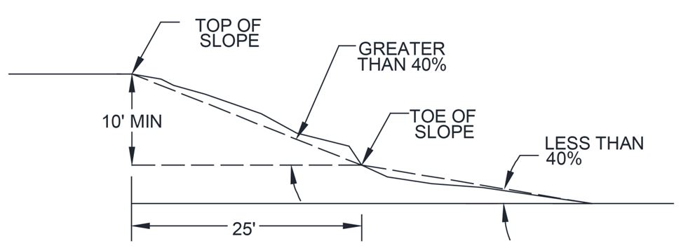
Top of Slope and Toe of Slope.
1. The “top of slope” is a distinct, topographical break in slope that separates slopes inclined at less than 40 percent from slopes 40 percent or steeper. When no distinct break exists, the top of slope is the uppermost limit of the area where the ground surface drops 10 feet or more vertically within a horizontal distance of 25 feet.
2. The “toe of slope” is a distinct topographical break in slope that separates slopes inclined at less than 40 percent from slopes 40 percent or steeper. When no distinct break exists, the toe of slope of a steep slope is the lowermost limit of the area where the ground surface drops 10 feet or more vertically within a horizontal distance of 25 feet.
“Water-dependent uses” shall be as defined in the city’s shoreline master program as currently adopted or hereinafter amended.
“Wetland” or “wetlands” means those areas that are inundated or saturated by ground or surface water at a frequency and duration sufficient to support, and that under normal circumstances do support, a prevalence of vegetation typically adapted for life in saturated soil conditions. Wetlands generally include bogs, swamps, marshes, ponds and similar areas. Wetlands do not include those artificial wetlands intentionally created from nonwetland sites, including, but not limited to, irrigation and drainage ditches, grass-lined swales, canals, detention facilities, wastewater treatment facilities, farm ponds and landscape amenities, or those wetlands created after July 1, 1990, that were unintentionally created as a result of construction of a road, street or highway. Wetlands may include those artificial wetlands intentionally created from nonwetland areas to mitigate conversion of wetlands (RCW 36.70A.030(21)).
Wetland Classification. For the purposes of general inventory, wetlands are defined by the criteria in the approved federal wetland delineation manual and the Western Mountains, Valleys, and Coast Regional Supplement (U.S. Army Corps of Engineers, 2010, or as amended).
“Wetland edge” means the boundary of a wetland as delineated based on the definitions contained in the approved federal wetland delineation manual and applicable regional supplements.
“Wetland hydrology” means the characteristics of water movement on, over and through a wetland system; the science dealing with the properties, distribution, and circulation of water through a wetland.
Wetland Rating. The rating for a wetland is as defined in the Washington State Wetlands Rating System for Western Washington (2014) or as revised by Ecology.
“Wetlands, non-federally regulated,” means wetlands that meet the following criteria:
1. Are outside of and not contiguous to any 100-year floodplain of a lake, river, or stream; and
2. Have no contiguous hydric soil or hydrophytic vegetation between the wetland and any surface water; and
3. Have no surface water connection to lake, stream, estuary or marine water body. (Ord. 3348 § 3 (Exh. A), 2025; Ord. 3287 § 5, 2022; Ord. 3198 § 3 (Exh. A), 2018; Ord. 3062 § 6, 2011; Ord. 2929 Exh. A § 1, 2006; Ord. 2899 § 1, 2005; Ord. 2892 § 1, 2005; Ord. 2688 § 1, 1999; Ord. 2535 § 1, 1996; Ord. 2483 § 1, 1995; Ord. 2319 § 1, 1992).
19.05.030 General provisions – Interpretations, relationship to other regulations, administrative rules, and maps.
A. Greater Restrictions. When any other development regulation of this code conflicts with this chapter, the regulation that provides greater protection to critical areas shall apply. If two or more critical areas are on the same site, the requirements that provide more protection to each of the critical areas shall apply. Any easements, covenants or deed restrictions to which the city is a party, which contain provisions more restrictive than this chapter, may be enforced by the city unless such easements, covenants or deed restrictions are specifically modified by the city council.
B. Interpretation. The provisions of this chapter shall be held to be minimum requirements in their interpretation and application and shall be liberally construed to serve the purposes of this chapter. The Washington State Environmental Policy Act and the regulations of other state and federal governmental agencies may supplement these requirements.
C. Relationship to Other Regulations.
1. Compliance with the provisions of this chapter does not constitute compliance with other federal, state, and local regulations and permit requirements that may be required (e.g., shoreline permits, hydraulic permit approval, Section 404 permits, etc.). The applicant is responsible for complying with all applicable requirements.
2. State Environmental Policy Act (SEPA). If applicable, these critical areas regulations shall apply in addition to review conducted under the State Environmental Policy Act (SEPA), as locally adopted. The SEPA review and threshold determination shall refer to the applicability of this chapter and any associated special reports that may be required. Subsequent approval of a critical areas permit shall incorporate SEPA mitigation measures as a condition of approval.
3. Shoreline Management Act (SMA). In accordance with the Growth Management Act (RCW 36.70A.480), SMA (RCW 90.58.610), and the SMP Guidelines (WAC 173-26-221), critical areas located in shoreline jurisdiction are regulated solely by the city’s shoreline master program (SMP) even if the SMP relies on this chapter for provisions to meet SMA requirements (e.g., incorporation by reference).
D. Administrative Rules/Procedures Manual. The director is authorized to adopt such administrative rules and regulations as necessary and appropriate to implement this chapter and to prepare and require the use of such forms as necessary for its administration.
E. City Inventory of Critical Areas.
1. The approximate location and extent of critical areas will be displayed on various inventory maps available at the city PCD.
2. Maps and inventory lists are not complete and are to be considered only as guides to the general location and extent of critical areas. Maps will be used for a preliminary determination to suggest the presence or absence of a critical area. However, where additional properties containing features meeting the definitions of critical areas contained in this chapter are identified by the city, properties containing such critical areas shall be subjected to the requirements of this chapter. Where mapped areas are confirmed through an advance determination under this chapter or through site visits and analysis of other available data as part of a permit application to not actually contain critical areas, the provisions of this chapter shall not apply. (Ord. 3348 § 3 (Exh. A), 2025; Ord. 3198 § 3 (Exh. A), 2018; Ord. 3062 § 4, 2011; Ord. 2899 § 1, 2005; Ord. 2892 § 1, 2005; Ord. 2688 § 2, 1999; Ord. 2535 § 2, 1996; Ord. 2319 § 1, 1992).
19.05.040 Critical area permit requirements – Applicability, exemptions, allowed activities, nonconforming structures, application requirements, special reports, and advance determinations.
A. Applicability.
1. All development proposals, alterations or activities, structures and facilities located within the maximum buffer distance for each critical area type shall comply with the provisions of this chapter whether or not a permit or authorization is required. No person, company, agency or applicant shall alter a critical area or buffer except as consistent with the purposes and requirements of this chapter.
2. The city shall not approve any permit or otherwise issue any authorization to alter the condition of any land, water, or vegetation or to construct or alter any structure or improvement without first assuring compliance with the requirements of this chapter.
B. Exemptions. To be exempt from this chapter does not give permission to degrade a critical area or ignore the risk from natural hazards, nor does it grant approval or authorization for any work to be done in any manner which may violate any federal, state or city laws. Any incidental damage to, or alteration of, a critical area that is not a necessary outcome of the exempted activity shall be mitigated at the responsible party’s expense.
1. Exempt Activities. The following activities shall be fully exempt from critical areas review, and not subject to the provisions of this chapter:
a. Emergencies. Alterations in response to emergencies which threaten the public health, safety and welfare or which pose an imminent risk of damage to private property as long as any alteration undertaken pursuant to this subsection is reported to the city no later than 30 days after the alteration. Only the minimum intervention necessary to reduce the risk to public health, safety, or welfare and/or the imminent risk of damage to private property shall be authorized by this exemption. The city shall confirm that an emergency exists and determine what, if any, additional applications and/or measures shall be required of the property owner to protect the critical area consistent with the provisions of this chapter, and to repair any damage to a preexisting resource. If the director determines that the action taken, or any part of the action taken, was beyond the scope of an allowed emergency action, then enforcement provisions of PTMC 19.05.120, Violations and penalties, shall apply. After the emergency, the person or agency undertaking the action shall fully fund and conduct necessary restoration and other mitigation for any impacts to the critical area and buffers resulting from the emergency action in accordance with an approved critical area report and restoration/mitigation plan. The person or agency undertaking the action shall apply for after-the-fact review and pay applicable fees; and the alteration, critical area report, and mitigation plan shall be reviewed by the city in accordance with the review procedures contained herein. Mitigation activities must be initiated within one year of the date of the emergency.
b. Existing Agricultural Activities. If a site has not been used for any agricultural purpose for 10 or more consecutive years from the date of the adoption of the ordinance codified in this chapter it is no longer considered agricultural.
C. Allowed Activities. The activities listed in subsections (C)(1) through (C)(16) of this section may occur within critical areas or required buffers if the director determines that the proposed activity will not impact the critical area in a manner contrary to the goals, purposes, objectives and requirements of this chapter and no purpose established under this chapter would be furthered by requiring a separate critical areas permit. Allowed activities are not exempt from other applicable development regulations and standards including but not limited to the city’s engineering design standards. If the director determines that the activity needs to be limited or conditioned to ensure impacts do not occur, the director may apply conditions to the underlying permit or require a minor critical area permit pursuant to subsection E of this section; in addition, the director may require the owner to enter into a restrictive covenant acknowledging the presence of a critical area and/or its buffer and restricting future activities on the property.
1. Modification to Existing Structures. Structural modifications of, addition to, or replacement of an existing legal nonconforming structure; provided, that such activity does not increase the potential impact to a critical area or its buffer. Within landslide hazard areas, modifications involving invasive foundation repair (e.g., digging new footings, drilling, driving pilings) or additions that add height to a nonconforming structure require a critical area permit and are only allowed with review of a special report demonstrating that no increased risk of the hazard will occur. Restoration of structures substantially damaged by fire, flood, or act of nature must be initiated within one year of the date of such damage, as evidenced by the submittal of a valid building permit. Structural repair shall be complete within two years after the catastrophe. (See also PTMC 17.88.030.)
2. Operations, Maintenance or Repair. Operation, maintenance or repair of existing structures and infrastructure improvements including: painting, roofing, septic tank cleaning, and repair of individual utility service connections consistent with best management practices if the activity neither:
a. Increases risk to life or property; nor
b. Further impacts critical areas or required buffers.
3. Previously Approved. An application for a building permit on a lot within a development for which the city has previously issued a land use permit, provided:
a. The prior permit or approval has not expired or, if no expiration date, no more than five years have lapsed since the issuance of that permit or approval;
b. There is no material change in the development proposal or site conditions;
c. There is no new information available that would alter the previous critical area review;
d. The director determines the previous review adequately evaluated impacts to critical areas and, if needed, provided adequate mitigation; and
e. The proposed development adheres to the permit conditions.
4. Activities Within the Improved Right-of-Way. Replacement, modification, installation, or construction of utility facilities, lines, pipes, mains, equipment, or appurtenances, not including substations, when such facilities are located within the improved portion of the public right-of-way or a city-authorized private roadway except those activities that alter a wetland or watercourse, such as culverts or bridges, or result in the transport of sediment or increased stormwater. Retention and replanting of native vegetation shall occur wherever possible along the right-of-way improvement and resulting disturbance. For geologically hazardous slopes (e.g., road cut/fill slope over 40 percent), engineered plans shall be required and, unless waived by the director, a geotechnical engineer shall review the plans and certify that, either as proposed or subject to recommended mitigation measures, the project will pose no unreasonable threat to persons or property, either on or off site, and the proposal will not decrease slope stability. This exception is not intended to allow for development in historically altered bluffs.
5. Minor Utility Projects. Ordinary maintenance and repair of electric, natural gas, cable communications and telephone lines and facilities. Replacement of an entire line segment with similar facilities may be exempted where the director determines the replacement would not significantly impact the function or values of a critical area(s).
6. Landscaping. Maintenance of existing landscaped areas using horticultural best practices, including selective pruning of trees and shrubs for safety and view protection, weeding, and planting, provided natural drainage patterns and topography are not altered. This does not include clearing or grading in order to develop or expand such activities in critical areas nor alteration of areas designated for retention as a condition of permit approval. Use of pesticides and herbicides is discouraged. Inappropriate use of pesticides and herbicides that result in adverse impacts to critical areas may be subject to enforcement action per Chapter 1.20 PTMC.
7. Preliminary mapping, survey work and subsurface exploration that result in insignificant disturbance of vegetation and soil.
8. Land clearing ordered by the director for abatement of a public nuisance that follows mitigation sequencing in PTMC 19.05.010(B).
9. Removal of trash and/or abandoned vehicles that results in insignificant disturbance of vegetation and soil.
10. Minor conservation and enhancement of critical areas that do not alter the location, dimensions or size of the critical area or buffer, and result in improvement of the critical area functions and values, including the following removal activities:
a. Removal of noxious weeds or invasive species as identified by the state is allowed when:
i. Activities are undertaken with hand labor including hand-held mechanical tools with no soil disturbance; when prescribed by the Jefferson County noxious weed control board, herbicides or biological control methods may be allowed and, in areas outside of landslide hazardous areas and their associated buffers, the use of riding mowers and light mechanical cultivation equipment may be allowed;
ii. Plants that appear on the State Noxious Weed List must be handled and disposed of in accordance with the best management practices appropriate to that species;
iii. Areas cleared by removal of noxious and/or invasive plant species must be revegetated with site-appropriate native species at natural densities and the site must be stabilized against erosion in accordance with the city’s engineering design standards;
iv. All work is performed above the ordinary high water mark and upland of wetlands; and
v. The following limits are not exceeded:
(A) Conservation/enhancement plans carried out by agencies with jurisdiction where no more than 3,000 square feet of soil may be exposed at any one time; or
(B) Not more than 500 square feet of soil may be exposed at any one time, as calculated cumulatively over one year, without a permit and critical area report prepared by a qualified consultant.
11. Vegetation management consistent with a previously approved critical area mitigation, restoration, remediation, or enhancement plan that requires ongoing maintenance and vegetation management beyond final inspection and the required monitoring period for the permitted project.
12. Removal of hazard (danger) trees within 50 feet of a permitted structure in a critical area for nesting and/or roosting by a priority species; provided recommended by a qualified arborist who verifies the hazard status prior to removal and that the best management practices avoid and minimize damage to remaining trees and vegetation; provided, that the applicant receives permission from the Department of Fish and Wildlife for removal of vegetation used for nesting and/or roosting by a priority species.
13. Maintenance of existing city, county, or Washington State Parks trails located in accordance with an adopted plan; provided, that maintenance is conducted in accordance with approved standards and does not involve expansion or fill in a wetland.
14. Development and construction activities located outside a critical area, and which are proposed to occur at a distance which is equal to or greater than the maximum buffers and setbacks required under the provisions of this chapter; provided, that the director determines the specificity of a special report is not required and no useful purpose would be served by the requirement to obtain a critical areas permit.
15. Activities located in proximity to an eagle nest or roost; provided, that the permittee shall strictly observe the guidance and requirements of the U.S. Fish and Wildlife Service’s National Bald Eagle Management Guidelines (May 2007 or as hereafter amended) and, if required, the permittee’s USFWS Bald Eagle Permit.
16. Activities located in proximity to a heron nest, provided activities are completed in the nonbreeding season (October 1st through January 31st) and no significant vegetation removed from within the WDFW recommended year-round buffer.
D. Allowed Activities for Specific Critical Areas – Specific Performance Standards Apply. For development proposals and activities which contain only aquifer recharge areas, frequently flooded areas/critical drainage corridors or seismic hazard areas, the director may waive the application requirements and delineation requirements of this section and compliance with the general performance standards for development contained in PTMC 19.05.060. The director must be satisfied that the performance standards provided for in the individual critical area regulations for a specific environmental category are met and no purpose established under this chapter would be furthered by requiring compliance with application requirements or the performance standards for development.
E. Minor Critical Area Permits (Type I-A).
1. Minor Critical Area Permits. Notwithstanding any other provision of this chapter, the PCD director may, subject to making the findings set forth below, issue a minor critical area permit, with conditions or limitations as determined by the director. Minor critical area permits may be granted only where the director finds:
a. The applicant has provided a report from a qualified consultant wherein the consultant has established a buffer that protects critical areas functions and values and the proposed activity lies outside of the consultant’s recommended buffer and any applicable setbacks. Where allowed by this chapter, the consultant may recommend reduced buffers, subject to any codified minimum buffers. If mitigation is necessary to meet no net loss, a Type II critical areas permit is required; or
b. The proposed activity is minor in nature (such as utility crossings, development or remodel of 250 square feet or less when no alteration of the critical area will occur, or minimal new landscaping) or creates only temporary impacts, and will have no off-site impacts; or
c. The proposed activity is to be conducted in an isolated, self-contained area where there is no danger to private or public property and minimal impact to the environment; or
d. The proposed activity is a critical areas restoration or enhancement project not otherwise required for mitigation of project impacts; or
e. The proposed activity involves the relocation of electric facilities, lines, equipment or appurtenances, not including substations, with an associated voltage of 55,000 volts or less; or
f. The proposed activity involves the relocation or installation of natural gas, cable communication, gas and telephone facilities, lines, pipes, mains, equipment or appurtenances; provided, the utility involves a conduit of two inches or less, a trench of two feet in width or less, and a construction corridor of 10 feet or less.
2. Minor critical area permits shall be conditioned to ensure that impacts to the critical area do not occur, and all activities conducted under the minor critical area permit shall comply with the provisions of this chapter and be carried out in a manner consistent with all laws and ordinances of the city of Port Townsend.
3. Minor critical area permits shall be processed as Type I-A permits.
F. Application Requirements and Delineations.
1. Where either the applicant indicates a critical area/critical areas buffer is present, the area is mapped as a critical area/critical areas buffer, or the director has a reasonable belief that a critical area/critical areas buffer is located on the site, and impacts to critical area functions and values are unavoidable, the below-listed requirements apply to the application. These requirements shall not apply if the applicant conclusively demonstrates to the satisfaction of the director that critical areas or buffers are not actually located on site. Otherwise, the applicant must identify and document critical areas and their required buffers on a site using technical reports and surveys, temporary field marking, and delineating critical areas on site plans and/or preliminary plats. The following is an outline of the steps required by the applicant in the critical area permit process. These steps supplement and augment the development permit application process set forth in the land development administrative procedures, Chapter 20.01 PTMC.
a. Staff Site Visit. If there is reason to believe a development project may involve a critical area/critical area buffer, a member of the city PCD staff may visit the site to establish the probable existence or absence of a critical area/critical area buffer.
b. Preapplication Consultation. Consistent with Chapter 20.01 PTMC, any person intending to apply for a critical areas permit is required to meet with the PCD staff during the earliest possible stages of project planning in order to discuss impact avoidance, minimization or compensation before large commitments have been made to a particular project design.
The director may waive this preapplication conference requirement if an applicant demonstrates, to the director’s satisfaction, experience with the requirements of the PTMC requirements and process that would render the preapplication conference unnecessary.
c. Prepare a site inventory and survey with five-foot contours, showing all existing natural and built features. The site survey is to be used as a base for the site construction plan. The survey requirement may be waived or modified by the director due to a determination that site factors do not require the specificity of a survey.
d. Provide a site construction plan delineating critical areas, their required buffer area, and significant vegetation (e.g., trees with a six-inch diameter at breast height). Unless the director waives one or more of the following information requirements, a site construction plan shall include:
i. On four lots or less, a plan description and maps at a scale no smaller than one inch equals 20 feet. On more than four lots, plan description and maps shall be no smaller than one inch equals 50 feet. In each case the plan description maps shall show the entire parcel of land owned by the applicant and the certified survey boundary of the critical area on the parcel (in the case of wetlands, this will require a delineation by a qualified consultant prior to the site survey);
ii. A description of the vegetative cover of the critical area and adjacent area including significant species and native vegetation;
iii. A site plan for the proposed development showing the location, width, depth and length of all existing and proposed disturbed areas, structures, roads, stormwater treatment and installations for the whole site, including those proposed to be located within the critical area and its buffer; utility locations and clearing and trenching locations should be identified along with the location of any existing utilities to be connected to the site;
iv. The exact location and specifications for all development activities including delineation of all disturbed areas, the amounts of filling and grading and methods of construction;
v. Elevations of the site and adjacent lots within the critical area and its buffer at contour intervals of five feet;
vi. Top view and typical cross-section views of the critical area and its buffer to the same scale as required in subsection (F)(1)(d)(i) of this section;
vii. Specific means proposed to mitigate any potential adverse environmental impact of the applicant’s proposal, including a detailed description of the mitigation sequence followed in the application.
e. Special Reports. If a critical area/critical areas buffer is confirmed to exist on the site, an applicant may be required to provide a critical area special report prepared by a qualified critical area consultant. The report shall be provided in both hard copy and electronic format.
i. Contents. Special reports shall identify and characterize any critical area/buffer as a part of the larger development proposal site, assess any hazards to the proposed development, assess impacts of the development proposal and construction-related activities on any critical areas/buffer on, or adjacent to, or adversely affected by proposed activities on the development proposal site, and assess the impacts of any alteration proposed for a critical area/buffer.
ii. Special reports shall use standards for best available science.
iii. Special reports for two or more types of critical areas must meet the report requirements for each type of critical area.
iv. Special reports shall be determined complete by the director, and (s)he may request more information as needed in order to protect the public and environment, and to ensure that the development is compatible with the land.
v. The specific requirements of special reports shall be identified at the preapplication consultation and may be required to be supplemented at the discretion of the director.
vi. The director may limit the required geographic area of the special report as appropriate if:
(A) The applicant, with assistance from the city, cannot obtain permission to access properties under separate ownership; or
(B) The proposed activity will affect only a limited part of the subject site.
vii. Special Reports Valid. Unless conditions have substantially changed, special reports shall be considered valid for five years; after such date the city shall determine whether a revision or additional assessment is necessary.
f. Stormwater management plan pursuant to PTMC 19.05.060(D)(6).
g. A site mitigation plan pursuant to PTMC 19.05.060(D)(7).
h. Waivers of Special Reports. The director may waive the requirement for a special report if there is substantial evidence showing that all the following are present:
i. There will be no alteration of the critical areas or required buffer; and
ii. The proposed development will not impact the critical area in a manner contrary to the goals, purposes, objectives and requirements of this chapter; and
iii. The minimum standards required by this chapter are met.
i. Exceptions to Special Reports. No special report is required for the following development proposals:
i. Any development or remodel of a structure or improvements when no alteration of the critical area will occur; except, any associated construction for additional parking or impervious surface greater than 250 square feet in the aggregate will require a special report.
ii. At the discretion of the director, reports previously compiled or submitted as part of a proposal for development may be used as a critical areas report to the extent that the requirements of this chapter and the report requirements for each specific critical area are met. Unless conditions have substantially changed, reports shall be considered valid for five years; after such date the city shall determine whether a revision or additional assessment is necessary. Supplemental critical areas reports may be required to address changes to the project scope and potential impacts or to address changes to applicable regulations. The director shall make such field investigations as are necessary to determine if the criteria for an exception are satisfied.
j. Field marking is required for all development proposals.
i. Prior to the preconstruction meeting, the applicant shall mark the following on the site to reflect the proposed site construction plan: the location of the building footprint, critical area(s) boundaries, the outer extent of required critical area buffers, areas to remain undisturbed, and trees and vegetation to be removed;
ii. Obtain the director’s approval on the field markings before beginning any permitted activities. Field markings are intended to prevent disturbance of critical areas and buffers and may include such items as temporary fences. Detailed requirements may be specified in the procedures manual prepared by the PCD; and
iii. Maintain the field markings for critical area(s) and areas to remain undisturbed throughout the duration of the permit.
k. A preconstruction meeting at the development site is required for all projects.
i. The meeting is to be attended by the applicant (or applicant’s agent) and city staff, to review specific project details and methods of construction. Subcontractors such as those conducting grading or excavation work may also be required to attend the meeting. Applicants are encouraged, but not required, to allow attendance by interested citizens.
ii. No construction activity, including land clearing or grading, shall be permitted until the information required by the appropriate critical area section is reviewed and approved by the director.
2. Advance Determination. Advance determinations shall be made in accordance with the Type I-A process in Chapter 20.01 PTMC.
a. A property owner or person with consent of the property owners may request an advance determination regarding the presence or absence of critical areas on a particular parcel outside of the normal permitting process. A request may be made upon payment to the development services department of the initial filing fee. The advance determination shall be based upon existing conditions at a particular site and shall be valid for a period of five years from the date of the special report. Should the director be unable to make a conclusive determination from a site visit and review of available information, the applicant may be requested to provide, at the applicant’s expense, additional information, reports or studies similar to those identified in subsection (F)(1) of this section to allow a conclusive determination to be made.
b. The director may grant an extension for up to two years upon written request by the original owner or the successor in title. Requests shall be filed in writing with the PCD director at least 90 days prior to the expiration of the approval period. An extension may be granted only where the director determines that there have been no changes in either the site conditions or applicable delineation methods. (Ord. 3348 § 3 (Exh. A), 2025; Ord. 3287 § 5, 2022; Ord. 3198 § 3 (Exh. A), 2018; Ord. 3062 §§ 4, 5, 7, 2011; Ord. 3026 § 1 (Exh. A-6 § 9), 2010; Ord. 2999 § 1 Exh. A, 2009; Ord. 2929 Exh. A § 4, 2006; Ord. 2899 § 1, 2005; Ord. 2892 § 1, 2005; Ord. 2688 § 3, 1999; Ord. 2535 § 3, 1996; Ord. 2319 § 1, 1992).
19.05.050 Critical area permit administration – Permit processing, public notice, exceptions, appeals, fees, and covenants.
This section contains the procedures that the city will use in processing critical area permits, as supplemented by Chapter 20.01 PTMC. This process includes exceptions that may be used by an applicant to lessen the development standards due to unique site characteristics which would make strict application of the standards unreasonable. Means to appeal administrative decisions are also included.
A. Review of Critical Areas Permits and Acceptance of Special Reports.
1. The director, as part of the review process, shall verify information submitted by the applicant to:
a. Confirm the nature and type of the critical areas, evaluate the special critical areas report and either accept the special report or remand it for corrections;
b. Determine whether the development proposal is consistent with the performance standards contained in this chapter;
c. Determine whether any proposed alterations to critical areas are necessary; and
d. Determine if the mitigation plans and bonding measures proposed by the applicant are sufficient to protect the public health, safety and welfare, and are consistent with the purposes, objectives and requirements of this chapter.
2. The applicant shall submit documents that demonstrate that any development proposal submitted conforms to the requirements of this chapter; and, if required, shall provide additional information with a special critical areas report. Critical area reports may be required in order to identify the presence, extent, and classification/rating of potential critical areas, as well as to analyze, assess, and mitigate the potential adverse impact to or risk from critical areas. The director may require peer review of any documents or reports at the expense of the applicant where the director deems it to be reasonably necessary to ensure the accuracy, effectiveness or objectivity of any of the documents, reports or measures proposed within them. A written determination from the director requiring peer review shall include the following information:
a. A statement giving the reason(s) peer review is requested (e.g., possible errors of fact or law, possible error in judgment, possible lack of objectivity, or the existence of additional or new information);
b. A statement of the specific areas of the report believed to be inadequate or in error, or not sufficiently definite to allow environmental analysis; and
c. The specific information sought (such as review of the wetland delineation line, the appropriateness of proposed mitigation procedures, feasibility of the plan or recommended action, conflicting scientific evidence, etc.).
3. The director may consult with other agencies, requesting information on the proposal’s impacts, and review of a special report’s contents that lie within the other agency’s jurisdiction or expertise. A written determination is not required before consultation with other agencies.
4. Review Criteria. The director may approve with conditions, or deny, any development proposal or regulated alteration in order to comply with the requirements and carry out the requirements of this chapter based on the following criteria:
a. The proposal does not pose an unreasonable threat to the public health, safety, or welfare on or off the development proposal site;
b. The proposal minimizes the impact on critical areas in accordance with mitigation sequencing in PTMC 19.05.060(A);
c. Any alterations permitted to the critical area are mitigated in accordance with mitigation requirements in PTMC 19.05.060(B);
d. The proposal is consistent with best available science and results in no net loss of critical area functions and values; and
e. The proposal meets the criteria in other applicable regulations and standards.
5. Approval of a development proposal pursuant to the provisions of this chapter does not discharge the obligation of the applicant to comply with the provisions of this chapter.
B. Permit Processing, Expiration, Modifications and Extensions.
1. The director shall consolidate the processing of related aspects and permits from other regulatory programs which affect activities in critical areas, such as SEPA, subdivision, etc., with the critical area review process established in this chapter to provide a timely and coordinated permit process as set forth in Chapter 20.01 PTMC.
2. Permits shall be valid for a period of one year from the date of issuance and shall expire at the end of that time if they are not acted upon, unless a longer or shorter period is specified by the director upon issuance of the permit.
3. Extensions of or minor modification to a critical areas permit may be requested by the original permit holder or the successor in title and approved by the PCD director subject to the provisions for Type I decisions in Chapter 20.01 PTMC. Requests shall be filed in writing with the PCD director at least 90 days prior to the expiration of the approval period or any subsequently approved extension.
4. Review Criteria. The director shall make written findings and conclusions that the following exist:
a. For extensions, the proposal remains consistent with all land use and development ordinances of the city in force at the time of the extension.
b. For modifications:
i. The modification will not be inconsistent with the findings, conclusions, and decision of the city approving the critical areas permit;
ii. The modification will not violate any applicable city policy or regulation; and
iii. The intent of the original conditions is not altered.
5. Extensions shall be granted by the director in one-year increments for a maximum of two years’ extension from the original permit expiration date.
6. Prior to the granting of an extension or minor modification, the director may require updated reports and/or additional hearings if, in his/her judgment, the original intent or the circumstances relevant to the review and issuance of the original permit have changed substantially, or if the applicant failed to abide by the terms of the original permit.
C. Public Notice. The city shall notify the public of proposals in accordance with the provisions of PTMC 20.01.150 and notice of final decision in PTMC 20.01.280.
D. Exceptions – Public Agency and Utility.
1. If the application of this chapter would prohibit a development proposal by a public agency or public utility, or development of a utility which is to be conveyed to a public agency/public utility, the applicant may request an exception pursuant to this section.
2. Exception Request and Review Process. Application for a public agency and utility exception shall be processed as:
a. A Type II permit as set forth in Chapter 20.01 PTMC if outside of shorelines jurisdiction.
b. A shoreline variance in accordance with Section 10.7 of the shoreline master program if in shorelines jurisdiction.
In addition to the application submittal requirements in PTMC 19.05.040(F), the applicant shall address the review criteria set forth below.
3. Public Agency and Public Utility Review Criteria. Exceptions may be granted for transportation and utilities where avoidance is not practicable. Any public agency/utility exception shall be reviewed and approved, approved with conditions, or denied based on the proposal’s ability to comply with the following criteria:
a. There is no other practical alternative to the proposed transportation/utility improvement with less impact on the critical areas;
b. The application of this chapter would unreasonably restrict the ability to provide utility services to the public;
c. The proposal does not pose an unreasonable threat to the public health, safety, or welfare on or off the development proposal site;
d. The proposal includes measures to protect and mitigate impacts to the critical area functions and values consistent with the best available science; and
e. The proposal is consistent with other applicable regulations and standards.
4. Burden of Proof. The burden of proof shall be on the applicant to show by a preponderance of the evidence that the applicant’s proposal meets all of the criteria.
E. Exception – Reasonable Use.
1. If the application of this chapter would deny all reasonable economic use of the subject property, the city shall determine if compensation is an appropriate action, or the property owner may apply for an exception pursuant to this section. A reasonable use exception is a measure of last resort for use only in those situations where all economic use of a property would be denied by the critical areas regulations.
2. Exception Request and Review Process. Application for a reasonable use request shall be processed as:
a. A Type II permit as set forth in Chapter 20.01 PTMC if outside of shorelines jurisdiction.
b. A shoreline variance in accordance with Section 10.7 of the shoreline master program, if in shorelines jurisdiction.
In addition to the application submittal requirements in PTMC 19.05.040(F), application for a reasonable use exception shall include:
a. Technical studies and other data that describe the possible injurious effects of the proposed development on occupiers of the land, on other properties, on public resources, and on the environment. Possible injurious effects must be described even when the injurious effect will become significant only in combination with similar effects from other developments; and
b. An explanation with supporting evidence of how and why compliance with the unmodified critical areas development standards would not permit reasonable use of the property.
3. Reasonable Use Review Criteria. The director may approve a reasonable use exception and modify a critical areas development standard only when all of the following findings can be made:
a. The application of this chapter would deny all reasonable use of the property;
b. No other reasonable use of the property has less impact on the critical area;
c. The proposed impact to the critical area is the minimum necessary to allow for reasonable use of the property;
d. The inability of the applicant to derive reasonable use of the property is not the result of actions by the applicant after the effective date of the ordinance codified in this chapter or its predecessor;
e. The proposal does not pose an unreasonable threat to the public health, safety, or welfare on or off the development proposal site;
f. The proposal will result in no net loss of critical area functions and values consistent with the best available science; and
g. The proposal is consistent with other applicable regulations and standards.
4. A critical areas development standard may be reduced, waived or otherwise modified only to the extent necessary to make the standard reasonable in light of all the facts and circumstances of a particular case. In modifying a development standard the director may impose reasonable conditions that prevent or mitigate the same harm that the modified regulation was intended to prevent or mitigate.
5. A director’s decision to modify a development standard may be appealed pursuant to the provisions of subsection G of this section and Chapter 20.01 PTMC. The director’s decision as to whether development pursuant to a modified development standard will cause significant injury shall be affirmed unless found to be clearly erroneous. The director’s decision as to whether strict application of a development standard is reasonable shall be accorded substantial weight.
F. Notice of Final Decisions. Notice of a final decision on any critical area development permit or reasonable use exception shall be mailed in accordance with PTMC 20.01.280.
G. Appeals and Stay During Pendency of Appeals.
1. An appeal of the final decision of the director on a critical area development permit (Type I-A or II), critical areas exception (Type II), or on an advance determination (Type I-A) shall follow the appeal procedure outlined in Chapter 20.01 PTMC.
2. An appeal of the director’s finding that a site is not within a critical area or its buffer under PTMC 19.05.040(F)(1) shall be deemed an appeal of the underlying development permit and consolidated with an appeal of the development permit.
3. Construction under any permit issued by the city shall be stayed until the expiration of any appeal period or the final resolution by the city of any appeal which has been filed under this chapter.
H. Fees. Fees shall be as set forth in Chapter 20.09 PTMC.
I. Hold Harmless Agreement. Unless waived by the PCD director upon a finding that no useful purpose would be served, the owner of a property containing critical areas on which a development proposal is submitted, except a public right-of-way or the site of a permanent public facility, shall file an agreement approved by the director and recorded with the Jefferson County auditor prior to the issuance of any permit or preliminary approval of a short plat or subdivision. Said agreement shall be in a form approved by the city attorney, shall hold harmless and indemnify the city and its employees from and against any liability for damages to persons or property as the result of construction or other action undertaken by the applicant on the subject property and be binding on the applicant and his/her successors and assigns.
J. Record Notice of Presence of Critical Area.
1. Unless waived by the PCD director upon a finding that no useful purpose would be served, the owner of any property with a field-verified presence of critical areas or their associated buffers pursuant to this chapter on which an activity subject to this chapter is proposed shall record a covenant with the Jefferson County auditor in a form approved by the city attorney. The covenant shall provide notice in the public record of the presence of a critical area or its buffer, the application of this chapter to the property, and that limitations on actions in or affecting such critical areas and their buffers may exist. The covenant shall be notarized and shall be recorded prior to approval of any development proposal for such sites.
2. The covenant shall run with the land. The applicant shall submit proof that the covenant has been filed for record before the city shall approve any development proposal and failure to provide such notice to the city or any purchaser prior to developing or transferring any interest in the property shall be a violation of this chapter. (Ord. 3348 § 3 (Exh. A), 2025; Ord. 3198 § 3 (Exh. A), 2018; Ord. 3026 § 1 (Exh. A-6 § 10), 2010; Ord. 2999 § 1 Exh. A, 2009; Ord. 2982 § 17, 2008; Ord. 2899 § 1, 2005; Ord. 2892 § 1, 2005; Ord. 2535 § 4, 1996; Ord. 2319 § 1, 1992).
19.05.060 General performance standards for development – Avoidance, mitigation, on-site and off-site, density, minimum lot size, subdivisions, preferred construction practices, impervious surface standards, stormwater plans, mitigation plans.
Per PTMC 19.05.040(D), the director may waive compliance with general performance standards for development proposals or alterations within areas that contain only aquifer recharge, frequently flooded/critical drainage corridors or seismic hazard areas.
A. Avoiding Impacts to Critical Areas.
1. Unless otherwise specified in this chapter, before impacting any critical area or its buffer, an applicant shall demonstrate that the actions listed in PTMC 19.05.010(B) have been taken.
2. Relief from Zoning Setbacks. In order to avoid critical area impacts and satisfy the buffer and setback requirements of this chapter, the director may approve up to a 50 percent reduction in the minimum yard setbacks established by the underlying zoning district for any two setbacks. For proposals within or contiguous to an R-I or R-II residential zoning district, a minimum five-foot setback must be retained. Critical areas permits requesting relief from zoning setbacks shall be processed according to the procedures for Type II land use decisions established in Chapter 20.01 PTMC.
B. Mitigation and Monitoring.
1. If mitigation is required under this chapter to compensate for adverse impacts, unless otherwise provided, an applicant shall:
a. Mitigate adverse impacts to:
i. Critical areas and their buffers; and
ii. The development proposal as a result of the proposed alterations on or near the critical areas; and
b. Monitor the performance of any required mitigation.
2. Unless it is determined that a higher level of ecological functioning would result from an alternate approach, compensatory mitigation for ecological functions shall be either in-kind and on site, or in-kind and within the same drainage basin or drift cell (if estuarine wetlands are impacted).
3. The department shall not approve a development proposal until mitigation and monitoring plans are in place to mitigate for alterations to the functions and values of critical areas and buffers.
4. Whenever mitigation is required, an applicant shall submit a critical area report that includes:
a. An analysis of potential impacts;
b. A site mitigation plan, as further described under subsection (D)(7) of this section, that meets the specific mitigation requirements in this chapter for each critical area impacted; and
c. A monitoring plan that includes:
i. A demonstration of compliance with this chapter;
ii. A contingency plan in the event of a failure of mitigation or of unforeseen impacts if: (A) the department determines that failure of the mitigation would result in a significant impact on the critical area or buffer; or (B) the mitigation involves the creation of a wetland; and
iii. A monitoring schedule that may extend throughout the impact of the activity or, for hazard areas, for as long as the hazard exists.
5. The department may require a performance or maintenance bond to ensure completion and success of proposed mitigation.
6. Mitigation shall not be implemented until after the department approves the site mitigation and monitoring plan. The applicant shall notify the department when mitigation is installed and monitoring is commenced and shall provide the city with reasonable access to the mitigation for the purpose of inspections during any monitoring period.
7. If monitoring reveals a significant deviation from predicted impact or a failure of mitigation requirements, the applicant shall implement an approved contingency plan. The contingency plan constitutes new mitigation and is subject to all mitigation including a monitoring plan and financial guarantee requirements.
C. Off-Site Mitigation.
1. To the maximum extent practicable, an applicant shall mitigate adverse impacts to a wetland or fish and wildlife habitat conservation area on or contiguous to the development site. The department may approve mitigation that is off the development site if an applicant demonstrates that:
a. There are no reasonable on-site or in-drainage basin opportunities (e.g., on-site options would require elimination of high functioning upland habitat), or on-site and in-sub-drainage basin opportunities do not have a high likelihood of success based on a determination of the natural capacity of the site to compensate for the impacts. Considerations should include: anticipated wetland mitigation replacement ratios, buffer conditions and proposed widths, available water to maintain anticipated hydrogeomorphic classes of wetlands when restored, proposed flood storage capacity, potential to mitigate riparian fish and wildlife impacts (such as connectivity); and
b. The off-site mitigation will achieve equivalent or greater hydrological, water quality and wetland or habitat functions.
2. When off-site mitigation is authorized, the department shall give priority to locations within the same sub-drainage basin as the development proposal site that meet one or more of the following:
a. Wetland Mitigation Banks. Credits from a wetland mitigation bank certified under Chapter 173-700 WAC may be used to compensate for impacts if located within the service area and consistent with the replacement ratios specified in the mitigation bank instrument;
b. In-Lieu Fee Mitigation (ILF). Credits from an approved in-lieu fee program may be used if located within the service area and consistent with the approved ILF program instrument. The applicant’s qualified wetland professional shall calculate debits associated with the proposed impacts using the credit assessment method specified in the ILF program;
c. Permittee-responsible mitigation sites that are established in compliance with the requirements of this chapter and approved by the department;
d. Public mitigation sites, including wetlands and fish and wildlife habitat conservation areas, that are identified and prioritized for mitigation by ecological assessments, such as the city’s stormwater management plan, the watershed management plan and detailed implementation plan for the Quilcene-Snow water resource inventory area (WRIA 17), and the Hood Canal integrated watershed plan;
e. Properties actively managed for preservation, open space or parks by a public entity or nongovernmental agency and approved by the department, provided the preservation is new and additive to existing preserved sites.
3. The department may require documentation that the mitigation site has been permanently preserved from future development or alteration that would be inconsistent with the functions of the mitigation. The documentation may include, but is not limited to, a conservation easement or other agreement between the applicant and owner of the mitigation site. The city may enter into agreements or become a party to any easement or other agreement necessary to ensure that the site continues to exist in its mitigated condition.
4. The department shall maintain a list of sites available for use for off-site mitigation projects.
5. The department may develop an in-lieu fee program to allow the payment of a fee in lieu of providing mitigation on a development site. The program should address:
a. When the payment of a fee is allowed considering the availability of a site in the same sub-drainage basin with comparable hydrologic and biological functions and potential for future habitat fragmentation and degradation; and
b. The use of the fees for mitigation on public or private sites that have been ranked according to ecological criteria through one or more programs that have included a public process.
D. General Performance Standards. The performance standards below apply to any development proposal or alteration on sites located wholly or partially within confirmed critical areas or their buffers. In addition to the following general performance standards, the performance standards of the applicable critical area also apply (e.g., a proposal impacting wetlands is subject to both the general performance standards and the standards set forth in PTMC 19.05.110).
1. Maximum Density. Densities less than the maximum permitted by the underlying zone may be required to protect the functions and values of confirmed fish and wildlife habitat conservation areas, frequently flooded areas, landslide/erosion hazard areas or wetlands. Site plans shall identify an accessible building pad located outside of the critical area and its buffer. This may necessitate lot consolidation, lot line adjustment, binding site plan or subdivision.
2. Construction – Preferred Practices. The following preferred construction practices shall be incorporated into the design of proposed critical area development where reasonable and practicable:
a. Use common access drives and utility corridors;
b. Design roads, walkways, and parking areas to parallel natural hillside contours while maintaining consolidated areas of natural topography, vegetation, and wildlife habitat; locate access in the least environmentally sensitive location practicable;
c. Use retaining walls that maintain existing natural slopes in place of graded artificial slopes;
d. Provide for necessary emergency vehicle access as approved by the director;
e. Building pads and disturbed areas should be located outside of critical areas and buffer boundaries.
3. Land Divisions – Building Pad.
a. The following requirements pertain to short plats, subdivisions, PUDs, lots of record and lot line adjustments only.
i. Identify, for each lot, an accessible building pad located outside of the critical area and its buffer.
ii. Determine the location of a building pad by considering vegetation, topography, critical areas, and the relationship of the proposed building pad to existing/proposed homes.
iii. Identify approved building pads and critical areas on final mylars.
iv. If insufficient land area exists outside of critical areas and their buffers for all building sites, the proposal may be required to develop at less than the maximum permissible density in order to avoid negative impacts to critical areas.
b. Binding Site Plans. All buildings proposed in a binding site plan shall be designed to be outside of critical areas and their buffer boundaries.
4. Clustering. As an alternative to a PUD process, through the Type II critical areas permit, where the presence of critical areas makes portions of a site unbuildable, an applicant may be permitted to transfer the density attributable to the unbuildable area of the property to another noncritical portion of the same site or property subject to the limitations of this section. Up to 100 percent of the density that could be achieved on the unbuildable portion of the site can be transferred to the noncritical area portion of the property, subject to:
a. The density limitation of the underlying zoning district;
b. The minimum lot size of the underlying zoning district may be reduced by up to 25 percent (a lot line adjustment/plat/full subdivision may be required);
c. Applicable setbacks may be reduced by 20 percent;
d. Lot coverage standards of underlying zoning regulations may be calculated based on the total site area and clustered on the buildable areas of the site; and
e. The critical area shall be protected and managed to prevent degradation and ensure protection of critical area functions and values in perpetuity. Permanent protection shall be achieved through recordation of easements, covenants or deed restrictions between the owner and the city or a tax-exempt organization (such as a land trust) or other governmental agency, in a form approved by the city attorney.
5. Impervious Surface Limits for Lots.
a. The maximum total percentage of land area that can be covered by impervious surfaces (including parking areas) is limited by the slope of the lot for all single-family developments in the R-I and R-II zoning districts as follows:
|
Lot Slope |
Impervious Surface Limit (expressed as % of actual land area) |
|---|---|
|
Less than 15% |
30% |
|
15 – 30% |
25% |
|
Greater than 30% |
20% |
Calculate the average slope of the entire lot. Apply the maximum percent of impervious surface to the land area as defined in this chapter. In shoreline jurisdiction: In no case shall total impervious area exceed 5,000 square feet for any one single-family detached dwelling and accessory structures (i.e., when a single-family home is proposed over multiple lots, the total impervious area must not exceed 5,000 square feet).
b. The director may grant a waiver of impervious surface limits, allowing the percent of impervious surface to equal the maximum percent of lot coverage allowed under PTMC Title 17 if the request is supported by the applicant’s qualified consultant, the proposal minimizes impacts to critical areas and meets one of the following criteria:
i. The proposal uses preferred practices, outlined in subsection (D)(2) of this section, which are appropriate for the lot; or
ii. The lot has a unique shape or proportion (i.e., a triangular lot, with a circuitous driveway corridor).
c. Wherever impervious surface limits conflict, the regulation that provides greater protection to critical areas shall apply.
6. Stormwater and Erosion Control.
a. Stormwater Management Plan. All development subject to the provisions of this chapter shall comply with the stormwater management manual, city engineering design standards manual, city stormwater plan, and adopted drainage basin plans.
i. Stormwater management plans shall be consistent with the standards contained in the stormwater management manual and EDS manual and must be developed on a case-by-case basis. Plans shall contain a description of existing or predicted problems and set forth solutions to each. Off-site measures may be required to correct existing on-site problems or to prevent new problems from occurring. Surface water discharge from the site shall not be greater than historic or predevelopment rates.
ii. If the development does not meet water quality standards established by law or administrative rules, the city may suspend further development work on the site until such standards are met.
b. Erosion control practices must be detailed using best management practices for siltation/filtration devices to control surface runoff during construction in accordance with the stormwater management manual and engineering design standards.
i. Applicants shall indicate erosion control measures on the site construction plan or stormwater control management plan, as appropriate for the project.
ii. These requirements shall be in place following the preconstruction meeting outlined in PTMC 19.05.040(F)(1)(k)(i) and shall be reviewed and approved prior to clearing and grading.
c. Applicants are also encouraged to consult the recommendations set forth in Chapter 5 of the current version of the Low Impact Development Technical Guidance Manual for the Puget Sound and Department of Ecology’s Raingarden Handbook for guidance concerning the protection of native soils and vegetation, and retention of hydrologic function.
7. Alterations and Disturbance.
a. A site mitigation plan shall be required by the director as an additional report submitted prior to final inspection if critical areas or critical slopes are identified on the site. (The requirements of the site mitigation plan may be included in the site construction plan if properly specified.)
b. The site mitigation plan shall:
i. Detail measures that restore the site to a revegetated condition after substantial foundation work and after project completion;
ii. Specify terrain, vegetation, and trees, in concert with the stormwater management plan, that restore surface and ground water filtration characteristics to preconstruction conditions;
iii. Retain characteristics compatible with the natural neighborhood environment.
c. Protection of Vegetation.
i. Areas of previously undisturbed natural vegetation in a critical area that have been damaged in violation of this chapter shall be replaced with compatible species in accordance with a city-approved site mitigation plan. Native vegetation shall be given preference.
ii. Areas infested with noxious weeds may be cleared and replanted in accordance with a city-approved mitigation plan.
8. Boundary Defined. As a condition of permit approval, the director may require permanent fencing or markers to define the edge of on-site critical areas or buffers. (Ord. 3348 § 3 (Exh. A), 2025; Ord. 3198 § 3 (Exh. A), 2018; Ord. 3062 § 8, 2011; Ord. 2982 § 14, 2008; Ord. 2929 Exh. A § 2, 2006; Ord. 2899 § 1, 2005; Ord. 2319 § 1, 1992).
19.05.070 Critical area 1 – Aquifer recharge areas.
A. Purpose. Aquifer recharge areas are characterized as porous geologic formations which store surface water that has percolated into the soil (ground water). Currently, aquifers in Port Townsend are not used as a drinking water source. This section provides protection measures to effectively maintain the quality of ground water by prevention of contamination so, if needed in the future, ground water may be used for agricultural or landscaping uses or as a potable (drinking) water source.
B. Classification.
1. Aquifer recharge areas are those lands in Port Townsend which have an aquifer of potential future or current use for drinking water, or which are a part of a system which maintains or affects the water quality of a wetland or other significant surface body of water and which allows water to enter the soil and geologic materials in ways and in quantities that replenish natural ground water systems and aquifers.
2. Aquifers are highly susceptible to damage when the overlying soils and geologic formations that filter surface waters feeding the aquifer are very coarse textured, allowing rapid translocation of surface pollutants to the aquifer. Aquifers under fine textured soils and geologic formations are less susceptible to surface influences and pollution.
3. Aquifers underlying areas that are currently developed or industrialized are more vulnerable to pollution than aquifers in undeveloped areas. Combining aquifer susceptibility indexes with vulnerability indexes allows identification of those areas most at risk. Aquifers with relatively high susceptibility indexes located in industrial areas have the highest potential to become a significant public health hazard. High vulnerability is characterized by land uses which produce contaminants that may degrade ground water quality or reduce ground water quantity. Low vulnerability is characterized by land uses which will not affect ground water quality or quantity.
4. Vulnerability to pollution is a function of depth of ground water, permeability of soils and geologic formations (susceptibility), presence of potential source of contamination, and any other relevant factors.
C. Regulated Development. The following types of development shall be regulated under this chapter:
1. High Risk Uses. The following land uses are considered high risk due to the probability and/or potential magnitude of their adverse effects on ground water. Unless otherwise waived by the director, a hydrogeologic assessment shall be required for:
a. High impact uses as defined in PTMC 17.08.030;
b. Hazardous substance processing or handling;
c. Hazardous waste treatment, storage and disposal facilities;
d. Landfills, junkyards, auto wrecking yards;
e. Golf courses;
f. Chemical manufacturing and reprocessing;
g. Asphalt manufacturing or treatment;
h. Electroplating and metal coating activities;
i. Storage and electrical battery processing and reprocessing; and
j. Other uses or activities determined by the city that may be likely to pose a threat to the aquifer.
2. Other Uses. The following land use activities may be allowed in aquifer recharge areas provided the director determines that the proposal meets the performance standards of subsection D of this section:
a. All industrial land uses;
b. All commercial uses including but not limited to vehicle repair and service stations;
c. Above ground storage of petroleum products or other hazardous substances;
d. Any development not connected to sanitary sewers which is located in a critical aquifer recharge area. In cases where on-site sewage treatment systems are allowed per Chapter 13.22 PTMC, Sewer Connections, additional requirements to condition on-site sewage treatment to prevent pollution of ground water may be required. In instances where on-site sewage treatment cannot be mitigated to prevent ground water contamination, the development permit application shall be denied.
D. Performance Standards for Development. All regulated development, as identified in this section, shall be designed and constructed subject to the following standards:
1. Underground hazardous substance and/or petroleum storage facilities shall:
a. Be designed to prevent releases due to corrosion or structural failure for the operational life of the tank;
b. Be protected against corrosion, constructed of noncorrosive material, steel clad with a noncorrosive material, or designed to include a secondary containment system to prevent the release of any stored substance;
c. Use material in the construction or lining of the tank that is compatible with the substance to be stored; and
d. Be consistent with any applicable Department of Ecology standards for construction and installation under Chapter 173-360 WAC.
2. Above ground hazardous substance and/or petroleum storage tanks shall:
a. Not be fabricated, constructed, installed, used or maintained in any manner which may allow the release of a hazardous substance to the ground, ground water, or surface waters of Port Townsend within an aquifer recharge area;
b. Not be fabricated, constructed, installed, used or maintained without having constructed around and under it an impervious containment area enclosing or underlying the tank;
c. Require a secondary containment system either built into the tank structure or dike system built outside the tank for all tanks located within an aquifer recharge area; and
d. Be consistent with any applicable Department of Ecology standards for construction and installation (WAC 173-180-320).
3. On-site sewage treatment systems shall obtain a septic system permit from Jefferson County environmental public health.
4. Vehicle Repair and Servicing.
a. Vehicle repair and servicing must be conducted over impermeable pads and within a covered structure capable of withstanding normally expected weather conditions. Chemicals used in the process of vehicle repair and servicing must be stored in a manner that protects them from weather and provides containment should leaks occur.
b. No dry wells shall be allowed in critical aquifer recharge areas on sites used for vehicle repair and servicing. Dry wells existing on the site prior to facility establishment must be abandoned using techniques approved by the State Department of Ecology prior to commencement of the proposed activity.
5. Stormwater runoff will be controlled and treated using BMPs and facility design standards as defined in Chapter 13.32 PTMC.
6. Agricultural and landscaping activities, specifically use of fertilizers, herbicides and pesticides in highly susceptible areas, shall be controlled. Federal, state, and local regulations of pesticides and water quality must be followed, including requirements for pesticide applicator licensing from the Washington State Department of Agriculture.
7. Applicants shall also consider the guidance set forth in Chapter 5 of the current version of the Low Impact Development Technical Guidance Manual for the Puget Sound for recommendations concerning the protection of native soils and vegetation, and retention of hydrologic function, during clearing and grading for development proposals.
E. Mitigation or Compensation. Any regulated development listed in subsection C of this section which results in degradation of aquifer recharge areas or aquifer water quality will require restoration of on-site disturbance in full to preconstruction conditions. Additional compensation shall be required in the form of fines, provision of drinking water for areas dependent on the degraded aquifer, or alternative environmental restoration.
F. Special Report Required. A hydrogeologic assessment may be required in those areas identified as highly susceptible or vulnerable or for uses posing a high risk of potential contamination. The report shall be prepared by a qualified consultant and shall address site- and project-specific conditions. The city may notify the U.S. Environmental Protection Agency, Washington State Department of Health, Washington Department of Ecology, and the Jefferson County health district to request comment during the preliminary stages of city’s review process. (Ord. 3348 § 3 (Exh. A), 2025; Ord. 3198 § 3 (Exh. A), 2018; Ord. 2899 § 1, 2005; Ord. 2319 § 1, 1992).
19.05.080 Critical area 2 – Fish and wildlife habitat conservation areas.
A. Purpose. Fish and wildlife habitat conservation areas are managed to provide suitable habitats for maintaining populations of species within their natural geographic distribution so that the habitat available is sufficient to support viable populations over the long term and isolated subpopulations are not created. The following regulations, in combination with the general performance standards for development contained in PTMC 19.05.060, are intended to provide reasonable measures to protect and conserve the habitat of fish and wildlife species and thereby maintain or increase their populations within Port Townsend. Habitat conservation will be accomplished by actively managing to maintain these species in their preferred habitats. However, habitat conservation does not require that all individuals of all species be protected. In appropriate circumstances, impacts resulting from regulated activities may be minimized, rectified, reduced and/or compensated for, consistent with this chapter.
B. Classification. All areas within the city of Port Townsend meeting one or more of the following criteria, regardless of any formal agency identification, are hereby designated critical areas and are subject to the provisions of this chapter and shall be managed consistent with the best available science. Maps maintained by federal, state and local agencies are to be used as a guide only. Final critical area designations are based on field conditions as determined by a qualified consultant. The following areas are defined as fish and wildlife habitat conservation areas and are identified under this chapter:
1. Areas with which state or federally designated endangered, threatened, and sensitive species have a primary association. Federally designated endangered and threatened species are those fish and wildlife species identified by the U.S. Fish and Wildlife Service and the National Marine Fisheries Service that are in danger of extinction or threatened to become endangered. Consult the State Department of Fish and Wildlife for the current status of state-listed endangered, threatened, and sensitive species;
2. Lands and waters containing documented habitats for plant and animal species listed in the Washington Department of Fish and Wildlife’s Priority Habitats and Species Program List. For PHS resources, consult WDFW’s PHS website (https://wdfw.wa.gov/species-habitats/at-risk/phs), PHS species lists (https://wdfw.wa.gov/species-habitats/at-risk/phs/list), and PHS maps (https://wdfw.wa.gov/species-habitats/at-risk/phs/maps). Priority habitats and species known to be identified and mapped by the Department of Fish and Wildlife in Port Townsend include but may not be limited to:
a. Great blue heron rookeries;
b. Brant and harlequin feeding areas;
c. Waterfowl concentrations at Kah Tai Lagoon;
d. Waterfowl wintering area at golf course pond;
e. Alcid breeding areas (the family Alcidae includes murrelets, pigeon guillemots, auklets, puffins and common murres);
f. Pinto abalone;
g. Geoduck; and
h. Dungeness crab.
Habitats and species of local significance may be added by action of the city council where the value and significance of such species locally can be established and sound scientific evidence can be presented to establish that the species’ existence is determined to be locally significant;
3. All public and private tidelands or bedlands suitable for shellfish harvest as designated by the Washington Department of Health’s classification system. Shellfish protection districts may be established pursuant to Chapter 90.72 RCW;
4. Critical saltwater habitats, as designated in WAC 173-26-221 and as may be subsequently amended by the state legislature, including but not limited to kelp and eelgrass beds, spawning areas for herring, smelt, sand lance; subsistence, commercial and recreational shellfish beds, mudflats, intertidal habitats with vascular plants, and areas with which priority species have a primary association. Kelp and eelgrass beds may be classified and identified by the Department of Natural Resources Aquatic Lands Program and the Department of Ecology;
5. Herring, smelt, sand lance and forage fish beach spawning areas;
6. Naturally occurring ponds (or created wetland ponds that are not stormwater detention/retention facilities) less than 20 acres and their submerged aquatic beds that provide significant fish or wildlife habitat;
7. Waters of the state include lakes, rivers, ponds, streams, inland waters, underground waters, salt waters, and all other surface waters and watercourses within the jurisdiction of the state of Washington, as classified in WAC 222-16-031 (Interim Type 1 – 5) or WAC 222-16-030 (Type S – Np), Forest Practices Rules and Regulations, depending on classification used. Also, consult the National Hydrography Dataset (https://www.usgs.gov/national-hydrography/national-hydrography-dataset) for potential waters identified by the U.S. Geological Survey. See PTMC 19.05.090 (Critical area 3 – Frequently flooded areas and critical drainage corridors) of this CAO and consult the city’s stormwater management plan to identify and address state waters that are not wetlands;
8. Lakes, ponds and streams planted with game fish, including those planted under the auspices of a federal, state, local or tribal program, and waters which support priority fish species as identified by the Washington Department of Fish and Wildlife;
9. Feeder bluffs along marine shorelines;
10. Marine nearshore habitat areas (i.e., the area encompassing the extreme low tide limit to the ordinary high water mark) and associated vegetated marine riparian areas; and
11. State natural area preserves, natural resource conservation areas, and state wildlife areas. The city concludes that there are none within the city’s jurisdiction at the time of adoption of this chapter.
C. Regulated Development. Unless specifically exempted under PTMC 19.05.040, all development proposals or alterations in classified fish and wildlife habitat conservation areas shall comply with the standards included in subsections D through G of this section. Designated fish and wildlife habitat conservation areas that are within shoreline jurisdiction are regulated under the city’s shoreline master program.
D. Performance Standards Applicable to All Development.
1. All development proposals or alterations in fish and wildlife habitat conservation areas shall:
a. Ensure the proposal does not degrade the quantitative and qualitative functions and values of the habitat. The director shall condition approvals within or adjacent to a habitat conservation area or its buffers as necessary to avoid, minimize and, where necessary, to mitigate potential adverse impacts.
b. Development activities allowed in fish and wildlife habitat conservation areas shall be consistent with the species located there, and shall be regulated additionally by restrictions defined in applicable federal, state and local regulations regarding the species. Development in or adjacent to areas used by state priority species shall be designed, located and constructed in consideration of Washington Department of Fish and Wildlife habitat recommendations.
c. Incorporate best management practices (BMPs), including measures to avoid impacts due to construction noise, light and timing.
2. Habitat conservation areas identified in required habitat management plans are to be conserved for the management and maintenance of fish and wildlife habitat. Habitat conservation areas may overlap with other identified critical areas. Likely areas of overlap include critical drainage corridors, geologically hazardous areas and wetlands.
E. Performance Standards for Terrestrial Habitats and Species.
1. Unless otherwise waived by the director, a habitat management plan shall be required for any development in or adjacent to areas identified as habitat for endangered, threatened or sensitive species and for breeding or nesting habitat of priority species. The plan shall incorporate mitigation recommendations developed in consideration of Washington Department of Fish and Wildlife habitat recommendations.
2. The habitat management plan shall show the exact location and extent of habitat conservation areas and any alteration of any habitat areas that may reduce the likelihood that the above listed species will survive or reproduce.
3. Bald Eagle Nests or Communal Roost. When a proposed activity may impact a bald eagle nest or roost, prior to the activity, the permittee shall strictly observe the guidance and requirements of the U.S. Fish and Wildlife Service’s National Bald Eagle Management Guidelines (May 2007 or as hereinafter amended) and, if required, the permittee’s USFWS Bald Eagle Permit.
4. Great Blue Heron Rookeries. Unless otherwise allowed pursuant to PTMC 19.05.040(C), a habitat management plan is required when a proposed activity may impact a rookery.
F. Additional Performance Standards for Shoreline Jurisdiction.
1. Development proposals and/or alteration within shoreline jurisdiction shall be mitigated to achieve no net loss of habitat function.
2. The following development standards shall also be applied in terrestrial habitat conservation areas that lie within the shoreline jurisdiction:
a. For residential development, total impervious surface area shall be limited to 20 percent of the actual land areas. In no case shall total impervious area exceed 5,000 square feet for any one single-family detached dwelling and accessory structure (i.e., when a single-family home is proposed over multiple lots the total impervious area must not exceed 5,000 square feet);
b. For nonresidential development, total impervious surface area shall be limited to 40 percent or 4,000 square feet, whichever is less; and
c. At least 25 percent of the lot shall be required to be retained or replanted in native vegetation. Areas to be retained shall include the largest contiguous and/or most waterward blocks of native vegetation located on site. If no areas of native vegetation remain, the vegetation retention area shall be replanted with species native to shoreline areas of the Quimper Peninsula. For additions and expansions of existing developments, replanting shall be commensurate with the degree of impact resulting from the new development.
G. Additional Performance Standards for Marine Habitats and Species.
1. Development in areas waterward of the ordinary high water mark shall require a critical areas report and shall give special consideration to the preservation and enhancement of anadromous fish habitat.
2. Development proposals shall be designed to first avoid and then minimize environmental impacts through the use of best available science and best management practices (e.g., Washington State Department of Fish and Wildlife’s Aquatic Habitat Guideline documents including WDFW’s Marine Shoreline Design Guidelines (Publication 01583)).
3. Unavoidable impacts to marine habitat and environmental processes shall be mitigated to achieve no net loss of habitat function.
4. All in-water development shall meet the requirements of the hydraulic project approval (HPA) process administered by Washington Department of Fish and Wildlife.
H. Additional Performance Standards for Critical Saltwater Habitats.
1. Structures, developments, and uses, including marinas, docks, piers, mooring areas, underwater parks, utilities, and shoreline modifications, shall not intrude into or be built over critical saltwater habitat unless the applicant can show that all of the following criteria can be met:
a. An alternative alignment or location is not feasible.
b. The project is designed to minimize its impacts on critical saltwater habitats and the shoreline environment.
c. Impacts to critical saltwater habitat functions are mitigated to result in equal or better ecological function.
d. The facility is a public or semipublic facility (e.g., water-dependent recreational or transportation facility or utility) and is in the public interest.
2. In areas not previously identified as critical saltwater habitat, the project proponent shall submit appropriate reconnaissance-level studies to determine whether critical saltwater habitats exist, whenever the following two conditions are applicable:
a. The proposed development, use or activity has the potential to cause significant adverse effects to a critical saltwater habitat; and
b. The beach or saltwater area that may be impacted by the proposed development, use or activity is the type of environment in which a critical saltwater habitat typically occurs.
3. Except as a habitat improvement or restoration measure, aquatic herbicide treatments, mechanical removal of vegetation and aquatic pesticide treatments shall not be used on critical saltwater habitats.
4. Sand, gravel or other materials shall neither be added nor removed from critical saltwater habitats, except when part of an approved restoration effort or as allowed in DR-6.6.1 of the shoreline master program.
5. New outfalls (including stormwater and sewer outfalls) and discharge pipes shall not be located in critical saltwater habitats or areas where outfall or discharge will adversely affect critical saltwater habitats unless the applicant can show that all of the following can be met:
a. There is no alternative location for the outfall or pipe.
b. The outfall or pipe is placed below the surface of the beach or bed of the water body.
c. The outfall discharges waterward of the subtidal zone.
d. The disturbed area will be revegetated with native plants.
e. The discharge point(s) on the outfall or discharge pipe is located so the discharges, including nutrients in the discharge and currents, do not adversely affect critical saltwater habitats.
I. Buffers or Setbacks.
1. The buffer width shall be established by an approved critical areas report prepared by a qualified consultant. To retain adequate natural habitat for classified species, buffer needs shall be assigned on a case-by-case basis, and the process and justification shall be described in the required critical areas report.
2. Buffer widths may be increased by the director if species present are sensitive to or endangered by habitat alteration, or if the area supports unique or rare plant communities, or contains rearing and nesting sites for endangered, threatened or priority species.
3. Buffer widths may be reduced by the director if the project includes buffer enhancement as part of an approved habitat management plan or if it is found that the affected property would be denied reasonable use as defined in PTMC 19.05.050(E). For critical saltwater habitats, buffer reductions shall not exceed 25 percent so that at least 75 percent of the standard width is maintained.
4. Building setback lines shall be measured from the outside edge of required buffers and no setback shall be less than 15 feet from an established buffer.
J. Mitigation or Compensation. Mitigation measures shall be based on the best available science and may include, but are not limited to:
1. Establishment of buffer zones;
2. Preservation of critically important vegetation and/or habitat features such as snags and downed wood, plants and trees;
3. Limitation of access to habitat area including fencing to deter unauthorized access;
4. Seasonal restriction of construction activities;
5. Establishing a timetable for periodic review of mitigation activities;
6. Using BMPs to avoid or reduce impacts;
7. Reducing the size, scope, configuration or density of the project;
8. Requirement of a performance or maintenance bond to ensure completion and success of proposed mitigation; and
9. Off-site mitigation as per PTMC 19.05.060(C).
K. Special Report Required. Unless otherwise waived by the director, a qualified consultant shall prepare a habitat assessment, and if adverse impacts are identified, a habitat management plan for the following activities:
1. Any development in or adjacent to areas identified as habitat for endangered, threatened or sensitive species or for breeding or nesting habitat of priority species.
2. Development in areas waterward of the ordinary high water mark.
3. Any development likely to cause impacts to marine habitat and environmental processes.
4. Unless otherwise exempt under Chapter 16.08 PTMC, a permit application to develop in the special flood hazard area shall include an assessment of the impact of the project on federal, state or locally protected species and habitat, water quality and aquatic and riparian habitat.
L. Report Content.
1. Habitat Assessment. A habitat assessment is an investigation of the project area to evaluate the potential presence or absence of designated critical fish or wildlife species or habitat. A critical areas report for a fish and wildlife habitat conservation area shall contain an assessment of habitats, including the following site- and proposal-related information at a minimum:
a. A project description including construction methods and timing;
b. Proposed site plan that includes the exact location and extent of habitat conservation areas, their associated buffers and proposed alteration of habitat areas. The site plan shall be prepared in sufficient detail to enable assessment of potential adverse impacts;
c. A detailed description of existing conditions on site and within 300 feet of the project area including topography, vegetation, all fish and wildlife habitat conservation areas, floodplains, other critical areas, and related buffers;
d. Identification of any species of local importance, priority species, or endangered, threatened, sensitive, or candidate species that have a primary association with habitat on or adjacent to the project area, and assessment of potential project impacts to the use of the site by the species;
e. A discussion of any federal, state, or local special management recommendations, including Washington Department of Fish and Wildlife habitat management recommendations, that have been developed for species or habitats located on or adjacent to the project area; and
f. A discussion of ongoing management practices that will protect habitat after the project site has been developed, including proposed monitoring and maintenance program.
2. Habitat Management Plan. If the habitat assessment concludes the project is expected to have an adverse effect on water quality and/or habitat or habitat functions, the applicant shall provide a plan to mitigate those impacts. The plan shall incorporate mitigation recommendations consistent with Washington Department of Fish and Wildlife habitat recommendations.
M. Additional Information Required for Special Flood Hazard Areas Pursuant to PTMC 16.08.130(F).
1. In addition to the habitat assessment requirements in subsection (L)(1) of this section, the habitat impact assessment shall be:
a. A biological evaluation or biological assessment developed per 50 CFR 402.12 to initiate federal interagency consultation under Endangered Species Act Section 7(a)(2); or
b. Documentation that the activity fits within Section 4(d) of the Endangered Species Act; or
c. Documentation that the activity fits within a habitat conservation plan approved pursuant to Section 10 of the Endangered Species Act, where any such assessment has been prepared or is otherwise made available; or
d. An assessment prepared in accordance with Regional Guidance for Floodplain Habitat Assessment and Mitigation, FEMA Region X, 2010. The assessment shall determine if the project would adversely affect:
i. Species that are federal, state or local listed as threatened or endangered;
ii. The primary constituent elements for critical habitat, when designated;
iii. Essential fish habitat designated by the National Marine Fisheries Service;
iv. Fish and wildlife habitat conservation areas;
v. Other protected areas and elements necessary for species conservation.
2. Habitat Management Plan Required for Special Flood Hazard Areas Pursuant to PTMC 16.08.130(F). If the habitat assessment concludes the project is expected to have an adverse effect on water quality and/or aquatic or riparian habitat or habitat functions, the applicant shall provide a plan to mitigate those impacts. The habitat management plan must be prepared in accordance with Regional Guidance for Floodplain Habitat Assessment and Mitigation, FEMA Region X, 2010.
a. If the USFWS or NMFS issues an incidental take permit under Section 10 ESA, or biological opinion under Section 7 ESA, then it can be considered to qualify as a plan to mitigate those impacts.
b. If the project is located outside the protected area, the mitigation plan shall include such avoidance, minimization, restoration, or compensation measures so that indirect adverse effects of development in the floodplain (effects to stormwater, riparian vegetation, bank stability, channel migration, hyporheic zones, wetlands, etc.) are mitigated such that equivalent or better habitat protection is provided.
c. If the project is located in the protected area, the mitigation plan shall stipulate such avoidance measures as are needed to ensure that there is no adverse effect during any phase of the project.
d. The plan’s habitat mitigation activities shall be incorporated into the proposed project. The floodplain development permit shall be based on the redesigned project and its mitigation components.
e. The building official shall not issue a certification of use or a certificate of occupancy until all work identified in the habitat assessment and mitigation plan has been completed or the applicant has provided the necessary assurance device in a form acceptable to the city attorney that unfinished portions of the project will be completed.
N. Additional Information Required in Shoreline Jurisdiction. In addition to the information required in subsection L of this section, critical areas reports must assess compliance with development regulations included in applicable sections of Chapter 6, Environmental Protection, of the city’s shoreline master program. (Ord. 3348 § 3 (Exh. A), 2025; Ord. 3198 § 3 (Exh. A), 2018; Ord. 3062 §§ 9 – 11, 2011; Ord. 2899 § 1, 2005; Ord. 2319 § 1, 1992).
19.05.090 Critical area 3 – Frequently flooded areas and critical drainage corridors.
A. Purpose.
1. The purpose of frequently flooded area regulations is to safeguard the public from threats to life or property associated with flooding, and to preserve the natural function of floodplains to store and control floodwaters, improve water quality and to provide for aquifer recharge. Furthermore, frequently flooded areas are connected floodplains and riparian systems that support ecosystem functions and climate resilience.
2. The purpose of critical drainage corridor regulations is to mitigate flooding, drainage, erosion or sedimentation problems that have resulted or may result from the cumulative impacts of development and urbanization. Support the benefits and ecosystem functions provided by healthy, connected floodplains and riparian systems, such as water attenuation, pollution filtration, flooding resilience, and drought resistance.
B. Classification. The following areas are defined as frequently flooded areas or critical drainage corridors and are protected under this chapter:
1. Frequently flooded areas are those lands which can be expected to flood at a frequency of once every 100 years, or which are subject to a one percent or greater chance of flooding in any year. These areas are mapped by the Federal Emergency Management Agency as “special flood hazards areas” indicated by zone “A” or “V” on the National Flood Insurance Program’s maps including AE, AO, AH, A1-99 and VE or as determined and designated by public works through basin modeling studies.
2. Critical drainage corridors (CDCs) are characterized as a year-round or intermittent naturally flowing watercourse which exhibits but is not limited to one or more of the following characteristics:
a. A stream or watercourse formed by nature or modified by humans;
b. Generally consisting of a defined channel with a bed for a substantial portion of its length on the lot; and/or
c. Perched ponds, ravines or other natural drainage features.
3. Critical drainage corridors have been identified and mapped by the public works department using the above criteria.
C. Regulated Development. Unless specifically exempted under PTMC 19.05.040(B):
1. All development proposals and alterations located within frequently flooded areas shall be regulated under this chapter, as well as Chapter 16.08 PTMC, Flood Damage Prevention.
2. All development proposals and alterations located on a site within a critical drainage area shall require the applicant to provide a survey of the centerline of a watercourse with the application for development. The project applicant shall be required to indicate the critical drainage corridor on the site construction plan (see reports and surveys) and these areas shall be marked in the field prior to the preconstruction meeting. Corridors shall be no less than 25 feet on each side of the centerline of the lowest point; the director of public works may require a larger corridor where warranted by field conditions.
D. Performance Standards for Development.
1. Standards for Frequently Flooded Areas.
a. Where applicable, development shall comply with the requirements of Chapter 16.08 PTMC, Flood Damage Prevention.
b. Development shall not reduce the effective base flood storage volume. With the exception of marine waters, effective storage volume must be maintained or mitigated in accordance with subsection F of this section, Mitigation or Compensation.
c. For those basins within Port Townsend having no natural outlet, the director may choose to increase design standards as needed to protect against damages that may result due to the increased likelihood of flooding.
2. Standards for Critical Drainage Corridors.
a. Access roads, trail crossings, and utilities may be allowed to cross critical drainage corridors where the city determines that no other practicable alternative exists and all unavoidable impacts are fully mitigated consistent with this chapter.
b. No fill or impervious surface is permitted within a critical drainage corridor except as outlined in subsection (D)(2)(a) of this section.
c. No mechanized power equipment may enter or be used within a critical drainage corridor without the written approval of the PCD director.
d. Building pads are not permitted within a critical drainage corridor.
e. Native and existing vegetation shall be maintained to the extent practicable.
E. Buffers and Setbacks. None; however, where frequently flooded areas or critical drainage areas overlap other critical areas, the larger buffer shall apply.
F. Mitigation or Compensation.
1. Development activities that would reduce the floodwater storage volume effectiveness shall be mitigated by creating compensatory storage on site if hydrologically practicable and consistent with watershed functional priorities, or, if allowed by the director, may be created off site, but within the same drainage basin.
2. The applicant shall design such compensatory storage facilities to meet or exceed current standards and design criteria contained or referenced in the city’s EDS manual.
3. The applicant shall provide a long-term maintenance plan for storage facilities.
4. If conditions warrant, the city may be requested, or may choose, to take over long-term maintenance of these facilities under appropriate legal agreements.
5. If development activity is allowed under this subsection, the applicant must sign a “hold-harmless” agreement indemnifying the city from claims related to the activity.
G. Special Reports. Unless otherwise waived by the director, development proposals or alterations located within frequently flooded areas and/or critical drainage corridors shall require a report prepared by a qualified consultant documenting that the proposed development meets the performance standards for development in subsection D of this section and, where impacts occur, impacts have been mitigated to ensure no net loss of critical area functions. (Ord. 3348 § 3 (Exh. A), 2025; Ord. 3198 § 3 (Exh. A), 2018; Ord. 2899 § 1, 2005; Ord. 2535 § 5, 1996; Ord. 2319 § 1, 1992).
19.05.100 Critical area 4 – Geologically hazardous areas.
A. Purpose. These critical areas are characterized by lot slope, soil type, geologic material, and ground water that may combine to create problems with slope stability, erosion and water quality during and after construction or during natural events such as earthquakes or excessive rainstorms. They pose a threat to the health and safety of citizens when incompatible development is sited in areas of significant hazard. Such incompatible development may not only place itself at risk, but also may increase the hazard to surrounding development and use. The following regulations, in combination with the performance standards for development, will guide development in these critical areas. The purpose of these regulations is to maintain the natural integrity of geologically hazardous areas and their buffers in order to protect adjacent lands from the impacts of landslides, mudslides, subsidence, excessive erosion and seismic events, and to safeguard the public from these threats to life or property. Construction in geologically hazardous areas will not be allowed when the potential risk to public health and safety cannot be reduced to a level comparable to the risk if the site were stable. This section acknowledges that some potential risk due to construction in these areas can be reduced through appropriate site planning and structural engineering design.
B. Classification. Areas in the city susceptible to one or more of the following types of hazards shall be designated as a geologically hazardous area:
1. Erosion hazard;
2. Landslide hazard;
3. Seismic hazard;
4. Tsunami hazard.
C. Designation of Specific Geologically Hazardous Areas.
1. Erosion Hazard Areas. Erosion hazard areas include areas likely to become unstable, such as steep slopes, and areas with unconsolidated soils. Any area containing soil or soil complexes described or mapped within the United States Department of Agriculture/Soil Conservation Service Soil Survey for Jefferson County as having a severe to very severe erosion hazard potential.
2. Landslide Hazard Areas. Landslide hazard areas are areas potentially subject to landslides based on a combination of geologic, topographic, and hydrologic factors. They include areas susceptible because of any combination of soil, slope (gradient), slope aspect, structure, hydrology, or other factors. Examples of these may include the following:
a. Areas of historic failures, such as:
i. Those areas delineated by the USDA’s Natural Resources Conservation Service as having a “severe” limitation for building site development;
ii. Those areas mapped by Ecology (Coastal Zone Atlas) or Washington Department of Natural Resources (WDNR) (slope stability mapping) as unstable (U or Class 3), unstable old slides (UOS or Class 4), or unstable recent slides (URS or Class 5);
iii. Areas designated as landslides on maps published by the USGS or WDNR; or
iv. Areas mapped in the Liquefaction Susceptibility Map of Jefferson County published by the Washington Department of Natural Resources;
b. Areas with all three of the following characteristics:
i. Slopes steeper than 15 percent;
ii. Hillsides intersecting geologic contacts with a relatively permeable sediment overlying a relatively impermeable sediment or bedrock; and
iii. Springs or ground water seepage;
c. Any area potentially subject to mass movement due to a combination of geologic, topographic, and hydrologic factors, but not limited to those areas mapped or described by the Soil Conservation Service, the Washington State Department of Ecology, Department of Natural Resources or U.S. Geologic Service. These classifications may be based on performance standards rather than mapping;
d. Any area potentially unstable due to erosion or sloughing as a result of rapid stormwater runoff, soil saturation or undercutting by wave action;
e. Critical Slopes. Any slope of 40 percent or steeper that exceeds a vertical height of 10 feet over a 25-foot horizontal run shall be presumed geologically hazardous unless it meets at least one of the following exceptions:
i. A qualified consultant has submitted a letter report that conclusively demonstrates to the satisfaction of the director that the slope does not pose a hazard; or
ii. The director, in consultation with the city engineer, determines that the area of 40 percent slope is an isolated manmade slope (this exception shall not apply to historically altered bluffs). Engineered plans shall be required and, unless waived by the director, a geotechnical engineer shall review the plans and certify that, either as proposed or subject to recommended mitigation measures, the project will pose no unreasonable threat to persons or property, either on or off site, and the proposal will not decrease slope stability.
3. Seismic Hazard Areas. Seismic hazard areas are areas subject to severe risk of damage as a result of earthquakes, slope failure, settlement, soil liquefaction or faulting. These areas are identified by the presence of poorly drained soils (greater than 50 percent silt and less than 35 percent coarse material), loose sand or gravel, peat, artificial fill and landslide materials, or soils with high organic content.
4. Tsunami Hazard Areas. Tsunami hazard areas are coastal areas and large lake areas susceptible to flooding and inundation as the result of excessive wave action derived from seismic or other geologic events. These areas have been mapped by WDNR.
D. Regulated Development.
1. Seismic and Tsunami Hazard Areas. Development proposals in seismic and tsunami hazard areas may be allowed and the director may waive the requirement for a critical areas permit per PTMC 19.05.040(C) provided the development shall comply with the provisions of subsection E of this section.
2. Development or alterations in landslide or erosion hazard areas or their associated buffers shall comply with the provisions of PTMC 19.05.060 and standards included in subsection E of this section.
E. Performance Standards for Development.
1. Standards for Seismic Hazard Areas and Tsunami Hazard Areas.
a. Standards for development of structures and improvements in seismic or tsunami hazard areas shall be in accordance with the provisions of building and construction codes as currently adopted by the city. No additional setback or other requirements are necessary to regulate structural design.
b. Critical facilities shall not be located in seismic or tsunami hazard areas unless mitigation is provided that renders the proposed development as stable as if it were not located within a seismic/tsunami hazard area.
c. Building plans for development within tsunami hazard areas or liquefaction prone areas shall include a note indicating the plans are being made in a tsunami hazard/liquefaction prone area.
2. Standards for Landslide and Erosion Hazard Areas. Development in landslide or erosion hazard areas shall comply with the following performance standards:
a. Stormwater Control.
i. Within all landslide and erosion hazard areas, the applicant must demonstrate that the temporary and final improvements to control runoff water quality, erosion, and sedimentation incorporate source controls, best management practices, and treatment and degradation controls that will not aggravate an existing problem or cause a new problem to occur.
ii. Surface drainage shall be directed away from landslide and erosion hazard areas. When no other solution is practicable, surface drainage piping may be located on the face of a geologically hazardous area when contained in a tight line (closed, nonleaking pipe) and in such a way that erosion will not be exacerbated and, if applicable, physical access along the shoreline is not degraded. Conditions may be applied to mitigate for aesthetic impacts of drainage systems as viewed from public areas.
b. Erosion Control.
i. Development within landslide and erosion hazard areas shall require a special report specifying detailed erosion control measures, which must be in place following the preconstruction meeting and approved prior to clearing and grading.
ii. Clearing of vegetation is allowed only within the dry season (generally from May 1st through September 30th), unless specifically approved by the director where conditions warrant such an allowance and the risk of hazard is controlled; clearing shall not occur until a permit or other written authority is obtained.
iii. The face of cut and fill on slopes shall be prepared and maintained to control against erosion and instability through utilization of surface mulches or rapid revegetation activities.
iv. The proposal shall not increase the rate of surface water discharge or sedimentation and shall not decrease adjacent property slope stability.
c. Preservation of Vegetation.
i. Whenever practicable, existing vegetation in these areas should remain in an undisturbed condition. If the area is unvegetated due to a previous disturbance, immediate efforts may be required to provide a persistent native vegetative cover, to prevent erosion or hazard.
ii. To minimize impacts to critical areas and on-site vegetation, the city may require clearing plans to be designed to minimize impacts to soil and understory vegetation by providing for sequencing and staging.
d. Development Design.
i. All development proposals shall be designed to minimize the footprint of building and other disturbed areas within landslide or erosion hazard areas. Common access drives and utility corridors are required where practicable; and
ii. All development shall be designed to minimize impervious lot coverage (e.g., under-structure parking, multilevel structures, etc.); and
iii. Structures shall be clustered where possible to reduce disturbance and maintain natural topographic character; and
iv. Structures shall conform to natural contour of slope and foundations should be tiered where possible to conform to existing topography of site; and
v. Roads, walkways and parking areas should be designed to parallel the natural contours; and
vi. Access shall be in the least sensitive area of the site; and
vii. Construction of private or public utility corridors may be allowed in landslide and erosion hazard areas only when no viable alternative exists; provided, that a special study accepted by the director concludes the development will not increase the risk of landslide or accelerated erosion.
e. Landscaping Design.
i. A site mitigation plan shall be prepared in accordance with PTMC 19.05.060(D)(7), unless waived by the director.
ii. The disturbed area of a development site shall be landscaped to provide long-term erosion control.
iii. Landscape plantings should encourage the use of drought-tolerant native vegetation.
iv. All landscaping must be completed in landslide and erosion hazard areas before a development will receive a final inspection.
f. Additional Standards for Landslide Areas.
i. All proposed development on geologically hazardous areas with slopes greater than 40 percent that exceed a vertical height of 10 feet and their required buffers shall be prohibited, except:
(A) As allowed under PTMC 19.05.040(B), Exemptions, or PTMC 19.05.040(C), Allowed Activities; or
(B) As allowed under PTMC 19.05.050(D), Exceptions – Public Agency and Utility, or PTMC 19.05.050(E), Exception – Reasonable Use; or
(C) For minor development to provide public access (e.g., public trails, stairs or view points); or
(D) Where the director, in consultation with the city engineer, determines that the area of 40 percent slope is an isolated manmade slope (this exception shall not apply to historically altered bluffs), engineered plans shall be required and, unless waived by the director, a geotechnical engineer shall review the plans and certify that, either as proposed or subject to recommended mitigation measures, the project will pose no unreasonable threat to persons or property, either on or off site, and the proposal will not decrease slope stability.
ii. Marine Bluffs. A special study shall be required for all proposed development occurring within the “marine bluff management zone,” as dictated by the bluff height and defined from the top of the slope:
|
Bluff Height |
Marine Bluff Management Zone |
|---|---|
|
Less than 10 feet |
No management zone |
|
10 – 50 feet |
50-foot management zone |
|
51 – 100 feet |
Equal to the height of the bluff |
|
Greater than 100 feet |
100-foot |
Figure 19.05.100(A) Marine Bluffs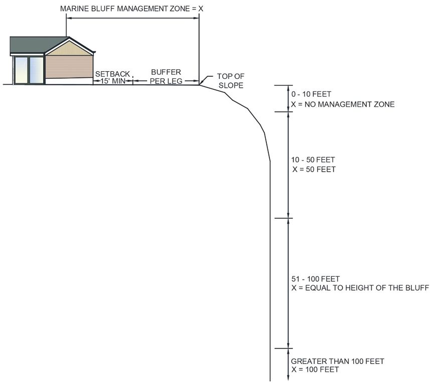
iii. Inland Banks. All proposed development occurring within 50 feet of the top of an inland bank classified as a landslide or erosion hazard area shall require preparation of a special study. This area shall hereinafter be referred to as the “inland bank management zone.”
Figure 19.05.100(B) Inland Banks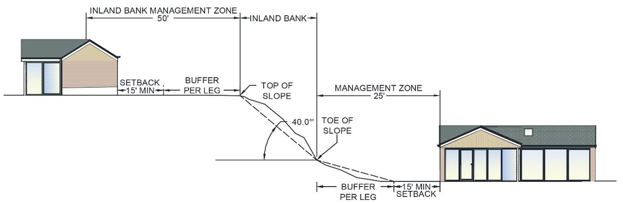
iv. Within the marine bluff and inland bank management zones set forth in this section, a buffer shall be established and maintained as set forth in subsection F of this section.
v. Alterations occurring within 25 feet of the toe of landslide hazard areas must conform to specific recommendations in the special study.
F. Buffers and Setbacks.
1. Licensed Engineering Geologist Recommends Buffer Subject to Minimum. Within the management zones established for marine bluffs and inland banks under subsections (E)(2)(f)(ii) and (E)(2)(f)(iii) of this section, the buffer width shall be established by an approved special study prepared by an engineering geologist with a Washington specialty license in engineering geology as specified in Chapter 18.220 RCW. The report shall be based upon the best available science, existing and proposed uses, risks of slope failure, and coastal erosion rates, if applicable. The recommended buffer shall be based on site-specific conditions and proposed design. In no case shall the buffer be less than the minimum buffers established by this section and/or the shoreline master program as applicable.
2. Minimum Buffer for New Land Division. Unless otherwise excepted in subsection (F)(3) of this section, for new short plats, subdivisions, binding site plans, and PUDs, a minimum buffer of 50 feet shall be provided from the edge of all marine bluffs, and 25 feet from inland banks; provided, that a reduction in the required buffer width to a distance equal to the height of the slope may be permitted when the special study concludes that doing so would not result in an increased risk to people or property or impacts to environmental processes. Erosion rates measured over at least a 75-year period shall be evaluated in any special study recommending a buffer width less than the applicable minimum. Under no circumstance may the buffer width for a marine bluff be less than a distance equal to the sum of the bluff erosion rate over at least 75 years plus 20 feet from the crest or 10 feet from the toe. (Also see PTMC 19.05.060(D)(3), Land Divisions – Building Pad.)
3. Minimum Buffer for Existing Lots and Infill Subdivisions. For existing lots, and infill subdivisions creating no additional waterfront lots, a landslide hazard area buffer less than that required for new subdivisions under subsection (F)(2) of this section may be permitted to allow development of a single-family residence if the special study concludes that doing so would not result in an increased risk to people or property or impacts to environmental processes. Additionally, for proposals within the shoreline jurisdiction, the reduced buffer width shall not be less than a distance equal to the sum of the bluff erosion rate over at least 75 years plus 20 feet from the crest of the bluff; or 10 feet from the sides and the toe of a marine bluff. (Also see PTMC 19.05.060(D)(3), Land Divisions – Building Pad.)
4. Building setback lines shall be measured from the outside edge of required buffers and no setback shall be less than 15 feet from an established marine bluff or inland bank buffer.
5. Remodels and/or additions to nonconforming structures (including new decks) shall be subject to the following:
a. A minor remodel or addition that neither changes an existing foundation line (i.e., no site alterations) nor increases the existing square footage of a structure by more than 25 percent shall not require preparation of a special study.
b. A remodel or addition that involves site alterations with an estimated cost of less than 50 percent of the market value of the existing structure shall require preparation of a special study, and shall be conditioned to locate new improvements away from identified hazard areas.
c. A remodel or addition that involves site alterations with an estimated cost of 50 percent or more of the market value of the existing structure shall be subject to the requirements applicable to new development. Such proposals shall also meet the view protection standards of the SMP.
6. Except as otherwise specified, buffer zones shall be retained in their natural condition. Where buffer disturbance has occurred during construction or in violation of this chapter, revegetation with native vegetation will be required unless the director approves a substitute vegetation with the same or better mitigation characteristics.
G. Special Reports. For geologically hazardous slopes, erosion hazard areas, and landslide hazard areas, unless waived by the director, a licensed engineering geologist shall complete a field investigation and geological assessment to determine whether or not the site for the proposed activity is located within 200 feet of the geologic hazard. The geological assessment shall be submitted in the most applicable form as follows:
1. A Geological Letter. When the geologist or geotechnical professional finds that no hazard area exists within 200 feet of the site, a stamped letter may be submitted demonstrating those findings;
2. A Geological Report. When the geologist finds that a geologically hazardous area exists within 200 feet of the site, but will not impact the site or need engineering design recommendations;
3. A Geotechnical Report. When the licensed engineering geologist finds that a geologically hazardous area exists within 200 feet of the site, and will require engineering design recommendations or other mitigation measures necessary in order to construct or develop within the geologically hazardous area. The report shall be stamped and signed by the LEG and co-sealed by an engineer who has a valid Washington State engineering license as specified in Chapter 18.43 RCW with appropriate training and experience for the proposed engineered design mitigation. For engineered mitigation measures on marine shorelines, the engineer shall have the appropriate training and experience in coastal processes.
Generally, avoiding impacts is the preferred option consistent with the mitigation sequence set forth in PTMC 19.05.060(A). When permitted, alterations of geological hazard areas or associated buffers may occur only for activities that meet the following criteria:
a. Will not increase the existing threat of the geological hazard to adjacent properties;
b. Will not decrease the factor of safety within the landslide area below the limits of 1.5 for static conditions and 1.1 for dynamic conditions. Analysis of dynamic (seismic) conditions shall be based on a minimum horizontal acceleration as established by the current version of the Washington State Building Code;
c. Will not adversely impact other critical areas;
d. Are designed so that the hazard to the project is eliminated or mitigated to a level equal to or less than predevelopment conditions; and
e. Are certified as safe as designed under anticipated conditions by a qualified engineer or geologist, licensed in the state of Washington.
The department may condition or deny proposals as appropriate to achieve these criteria. Conditions may include limitations of proposed uses, modification of density, alteration of site layout, and other appropriate changes to the proposal. (Ord. 3348 § 3 (Exh. A), 2025; Ord. 3198 § 3 (Exh. A), 2018; Ord. 3062 §§ 12, 13, 14, 2011; Ord. 2982 §§ 15, 16, 2008; Ord. 2899 § 1, 2005; Ord. 2867 § 2, 2004; Ord. 2319 § 1, 1992).
19.05.110 Critical area 5 – Wetlands.
A. Purpose. The purpose of these regulations is to protect the public from harm by preserving the functions of wetlands and streams as recharge for ground water, flood storage, floodwater conveyance, habitat for fish and wildlife, sediment control, pollution control, surface water supply, aquifer recharge and recreation.
B. Classification.
1. “Wetland” or “wetlands” means areas that are inundated or saturated by surface water or ground water at a frequency and duration sufficient to support, and that under normal circumstances do support, a prevalence of vegetation typically adapted for life in saturated soil conditions. Wetlands generally include swamps, marshes, bogs, and similar areas. Wetlands do not include those artificial wetlands intentionally created from nonwetland sites, including, but not limited to, irrigation and drainage ditches, grass-lined swales, canals, detention facilities, wastewater treatment facilities, farm ponds, and landscape amenities, or those wetlands created after July 1, 1990, that were unintentionally created as a result of the construction of a road, street, or highway. Wetlands may include those artificial wetlands intentionally created from nonwetland areas created to mitigate conversion of wetlands.
2. Designated wetland areas have been identified by:
a. U.S. Fish and Wildlife Services National Wetlands Inventory;
b. Wetlands identified within the land use/land cover inventories of the Department of Ecology Coastal Atlas;
c. Hydric soils, soils with significant soil inclusions, and “wet spots” identified within the Jefferson County soil survey;
d. City of Port Townsend inventories and delineations, existing and as hereinafter amended.
3. For the purposes of a general inventory, wetlands will be defined in accordance with the approved federal wetland delineation manual and applicable regional supplements.
4. Wetlands shall be rated according to the Washington State Wetland Rating System for Western Washington (2014) or as revised by Ecology.
a. Category I. Category I wetlands are:
i. Relatively undisturbed estuarine wetlands larger than one acre;
ii. Wetlands that are identified by scientists of the Washington Natural Heritage Program/DNR as wetlands of high conservation value;
iii. Bogs;
iv. Mature and old growth forested wetlands larger than one acre;
v. Wetlands in coastal lagoons;
vi. Interdunal wetlands that score eight or nine points for habitat, and are larger than one acre; and
vii. Wetlands that score 23 points or more on the questions relating to functions.
b. Category II. Category II wetlands are:
i. Estuarine wetlands smaller than one acre or coastal lagoons smaller than one-tenth of an acre, or disturbed estuarine wetlands larger than one acre or disturbed coastal lagoons larger than one-tenth of an acre;
ii. Wetlands that score between 20 and 22 points on the questions related to the functions present; and
iii. Interdunal wetlands larger than one acre and that score seven or lower for habitat, or those found in a mosaic of wetlands and dunes larger than one acre.
c. Category III. Category III wetlands are:
i. Wetlands with a moderate level of functions (scores between 16 and 19 points); and
ii. Interdunal wetlands between one-tenth of an acre and one acre in size.
d. Category IV. Category IV wetlands have the lowest levels of functions (scores less than 16 points) and are often heavily disturbed. These are wetlands that are capable of being replaced, and in some cases improved. However, experience has shown that replacement cannot be guaranteed in any specific case. These wetlands may provide some important functions, and should be protected.
C. Regulated Development.
1. Regulated wetlands include all Category I and II wetlands, and all Category III and IV wetlands.
2. Regulated wetlands do not include those artificial wetlands intentionally created from nonwetland sites, including, but not limited to, irrigation and drainage ditches, grass-lined swales, canals, detention facilities, wastewater treatment facilities, farm ponds and landscape amenities, or those wetlands created after July 1, 1990, that were unintentionally created as a result of construction of a road, street or highway. These wetlands are considered to be facilities and require maintenance. At such a time when these facilities are not maintained for a period of more than five years, yet still retain wetland characteristics, they revert to regulated wetland status if they meet the parameters of the regulated wetland definition.
3. If a wetlands delineation is required, it must be conducted by a qualified (wetlands) critical areas consultant in accordance with the approved federal wetland delineation manual and applicable regional supplements.
a. Prior to construction, the applicant shall mark and provide an accurate ground verified map (i.e., GPS with submeter accuracy, or equivalent method) of the wetland edges shall be provided, and marked by staking on the site. See PTMC 19.05.040(F)(1)(j).
b. Where the applicant has provided a delineation of the wetland boundary, the director shall verify the accuracy of, and may render adjustments to, the boundary delineation. In the event the adjusted boundary delineation is contested by the applicant, the director shall, at the applicant’s expense, obtain expert services from a third party to render a final delineation.
c. The director, when requested by the applicant, may perform the delineation in lieu of delineation by the applicant.
i. The director shall consult with qualified professional scientists and technical experts or other experts as needed to perform the delineation.
ii. The applicant will be charged for the costs incurred.
D. Performance Standards for Development.
1. Activities and uses shall be prohibited in wetlands and wetland buffers, except as provided for in this subsection. A critical areas report may be required to support the requested activity and, where impacts cannot be avoided, mitigation provided in accordance with this section.
2. Category I Wetlands. Activities and uses that result in alteration of Category I wetlands and their buffers shall be prohibited except as provided for in PTMC 19.05.040(B), Exemptions, PTMC 19.05.050, exceptions, and subsection (D)(5) of this section.
3. Category II and III Wetlands. Except as specified in subsection (D)(5) of this section, for Category II and III wetlands and their buffers, the following standards shall apply:
a. Water-dependent activities may be allowed where there are no practicable alternatives that would have a less adverse impact on the wetland, its buffers and other critical areas, and where the use meets the intent of this chapter.
b. Non-water-dependent activities and uses shall be prohibited unless the applicant can demonstrate that:
i. The basic project purpose cannot reasonably be accomplished on another site or sites in the general region while still successfully avoiding or resulting in less adverse impact on a wetland; and
ii. All on-site alternative designs that would avoid or result in less adverse impact on a wetland or its buffer, such as a reduction in the size, scope, configuration or density of the project, are not feasible.
Full compensation for the loss of acreage and functions of wetland and buffers shall be provided under the terms established under subsection H of this section.
4. Category IV Wetlands (Except Small Hydrologically Isolated Wetlands (see subsection (D)(5) of this section)). Activities and uses that result in unavoidable impacts may be permitted in Category IV wetlands and associated buffers in accordance with an approved critical area report and compensatory mitigation plan, and only if the proposed activity is the only reasonable alternative that will accomplish the applicant’s objectives. Full compensation for the loss of acreage and functions of wetland and buffers shall be provided under the terms established under subsection H of this section.
5. Exemptions From Avoidance Requirement. The director may exempt the following wetlands from the requirement to avoid impacts (PTMC 19.05.060(A)), and these wetlands may be filled if the impacts are fully mitigated based on subsection (H)(2) of this section. If available, impacts should be mitigated through the purchase of credits from an in-lieu fee program or mitigation bank. In order to verify the following conditions, a critical area report for wetlands meeting the requirements of this chapter must be submitted:
a. All isolated Category IV wetlands less than 4,000 square feet in area that:
i. Are not associated with riparian areas or their buffers;
ii. Are not associated with shorelines of the state or their associated buffers;
iii. Are not part of a wetland mosaic;
iv. Do not score six or more points for habitat function based on the July 2024 Version 2 of the Western Washington Rating System (Ecology Publication No. 23-06-009, or as revised);
v. Do not contain a priority habitat or a priority area for a priority species identified by the Washington Department of Fish and Wildlife, do not contain federally listed species or their critical habitat, or species of local importance identified in PTMC 19.05.080(B).
b. Wetlands less than 1,000 square feet that meet the above criteria and do not contain federally listed species or their critical habitat are exempt from the buffer provisions in this chapter.
6. Stormwater Management. A wetland or its buffer may be physically or hydrologically altered to meet the requirements of an LID, runoff treatment or flow control BMP only if all of the following criteria are met:
a. The wetland is classified as a Category IV, or a Category III wetland with a habitat score of three to five points;
b. There will be “no net loss” of functions and values of the wetland;
c. The wetland does not contain a breeding population of any native amphibian species;
d. The hydrologic functions of the wetland can be improved as outlined in questions 3, 4, and 5 of Chart 4 and questions 2, 3, and 4 of Chart 5 in the “Guide for Selecting Mitigation Sites Using a Watershed Approach,” (available here: https://apps.ecology.wa.gov/publications/documents/0906032.pdf) or the wetland is part of a priority restoration plan that achieves restoration goals identified in the shoreline master program or other local or regional watershed plan;
e. The wetland lies in the natural routing of the runoff, and the discharge follows the natural routing;
f. All regulations regarding stormwater and wetland management are followed, including but not limited to local and state wetland and stormwater codes, manuals, and permits;
g. Modifications that alter the structure of a wetland or its soils shall be appropriately permitted. Existing functions and values that are lost shall be compensated/replaced;
h. Stormwater LID BMPs required as part of new and redevelopment projects can be considered within wetlands and their buffers. However, these areas may contain features that render LID BMPs infeasible. A site-specific characterization is required to determine if an LID BMP is feasible at the project site.
E. Trails and Trail-Related Facilities. Construction of public and publicly accessible private trails and trail-related facilities (e.g., benches and viewing platforms) may be allowed in wetlands or wetland buffers provided such facilities shall meet all of the following criteria:
1. Trails and related facilities shall, to the extent practicable, be placed on existing road grades, utility corridors, or any other previously disturbed areas.
2. Trails and related facilities shall be planned to minimize removal of trees, soil disturbance and existing hydrological characteristics, shrubs, snags and important wildlife habitat.
3. Viewing platforms, interpretive centers, benches and access to them shall be designed and located to minimize disturbance of wildlife habitat and/or critical characteristics of the affected wetland. Platforms shall be limited to 100 square feet in size, unless demonstrated through a wetland mitigation plan that a larger structure will not result in a net loss of wetland functions.
4. Trails and related facilities shall generally be located outside required buffers. Where trails are permitted within buffers they shall be located in the outer 25 percent of the buffer except where wetland crossings or direct access to viewing areas have been approved by the department.
5. Trails shall generally be limited to pedestrian use unless other more intensive uses, such as bike or horse trails, have been specifically allowed and mitigation has been provided. Trail width shall not exceed five feet unless there is a demonstrated need, subject to review and approval by the department. Trails shall be constructed with pervious materials except where determined impracticable.
F. Utilities. Unless otherwise exempt per PTMC 19.05.040(B), placement of utilities under a wetland or within a wetland buffer may be allowed when no reasonable alternative location is available; provided, that:
1. Entrance/exit portals are located outside of the wetland buffer boundary to the extent practicable;
2. Drilling does not interrupt the ground water connection to the wetland or percolation of surface water down through the soil column. Specific studies by a hydrologist are necessary to determine whether the ground water connection to the wetland or percolation of surface water down through the soil column is disturbed;
3. New utility corridors shall be revegetated with appropriate native vegetation at not less than preconstruction densities or greater immediately upon completion of construction, or as soon thereafter as possible if due to seasonal growing constraints. The utility shall ensure that such vegetation survives; and
4. The utility shall agree to conduct corridor maintenance in a manner that protects the regulated wetland and buffer environment. Measures may include but are not limited to:
a. Spray painting or sandblasting of utility equipment may only be allowed if appropriate containment measures are used. Lead-based paints shall not be used.
b. No pesticides, herbicides or fertilizers may be used in wetland areas or their buffers except those approved by the U.S. Environmental Protection Agency (EPA) and Washington Department of Ecology. Where approved, federal, state, and local regulations of pesticides and water quality must be followed, including requirements for pesticide applicator licensing from the Washington State Department of Agriculture.
G. Buffers and Setbacks.
1. Wetland buffers shall be measured perpendicularly from the wetland boundary as delineated in the field (see the approved federal wetland delineation manual and applicable regional supplements).
2. Buffers shall be required to protect important wildlife habitat and wetland features, values and functions from the adverse impacts of adjacent land uses.
a. The width of the buffer zone shall be based upon wetland category, intensity of impacts, and wetland functions or special characteristics, as set forth below in Table 19.05.110(A):
|
Table 19.05.110(A). Buffer Widths |
||
|---|---|---|
|
Wetland Characteristics |
Buffer Widths by Impact of Land Use |
Other Measures Recommended for Protection |
|
Category I Wetlands |
||
|
Wetlands of High Conservation Value |
Low – 125 feet |
No additional discharges of surface water; no septic systems within 300 feet; restore degraded parts of buffer. |
|
Bogs |
Low – 125 feet |
No additional surface discharges; restore degraded parts of buffer. |
|
Forested |
Buffer size to be based on score for habitat functions or water quality functions. |
If forested wetland scores high for habitat, need to maintain connectivity to other natural areas; restore degraded parts of buffer. |
|
Estuarine |
Low – 100 feet |
Reserved. |
|
Wetlands in Coastal Lagoons |
Low – 100 feet |
Reserved. |
|
High Level of Function for Habitat (Score for Habitat 8 – 9 Points) |
Low – 150 feet |
Maintain connectivity to other natural areas; restore degraded parts of buffer. |
|
Interdunal Wetland with High Level of Function for Habitat (Score for Habitat 8 – 9 Points) |
Low – 150 feet Moderate – 225 feet High – 300 feet |
Maintain connectivity to other natural areas; restore degraded parts of buffer. |
|
Moderate Level of Function for Habitat (Score for Habitat 6 – 7 Points) |
Low – 75 feet |
Reserved. |
|
High Level of Function for Water Quality Improvement (8 – 9 Points) and Low for Habitat (Less Than 6 Points) |
Low – 50 feet Moderate – 75 feet High – 100 feet |
Reserved. |
|
Not Meeting the above Characteristics |
Low – 50 feet |
Reserved. |
|
Category II Wetlands |
||
|
High Level of Function for Habitat (Score for Habitat 8 – 9 Points) |
Low – 150 feet |
Maintain connectivity to other natural areas. |
|
Moderate Level of Function for Habitat (Score for Habitat 6 – 7 Points) |
Low – 75 feet Moderate – 110 feet |
Reserved. |
|
High Level of Function for Water Quality Improvement and Low for Habitat (Score for Water Quality 8 – 9 Points; Habitat Less Than 6 Points) |
Low – 50 feet High – 100 feet |
No additional discharges of untreated runoff. |
|
Estuarine |
Low – 75 feet |
Reserved. |
|
Wetlands in Coastal Lagoons |
Low – 75 feet |
Reserved. |
|
Interdunal |
Low – 75 feet |
Reserved. |
|
Not Meeting above Characteristics |
Low – 50 feet |
Reserved. |
|
Category III Wetlands |
||
|
Function of habitat score 8 – 9 |
Low – 50 feet |
No additional discharges of untreated runoff. |
|
Moderate Level of Function for Habitat (Score for Habitat 6 – 7 Points) |
Low – 75 feet |
Reserved. |
|
Score for Habitat 3 – 5 Points |
Low – 40 feet |
Reserved. |
|
Category IV Wetlands |
||
|
Score for All 3 Basic Functions Less Than 16 Points |
Low – 25 feet |
Reserved. |
See also subsections (G)(4), (5) and (6) of this section for provisions relating to increased and decreased buffer widths and buffer width averaging.
b. Land use intensity (i.e., low, moderate, high) shall be determined using Table 19.05.110(B) set forth below:
|
Table 19.05.110(B). Land Use Impacts and Intensity Levels |
|||
|---|---|---|---|
|
Level of Impact from Proposed Land Use |
Proposed Land Use Types |
||
|
High |
|
||
|
|
|
||
|
|
|
||
|
|
|
||
|
|
|
||
|
|
|
||
|
Moderate |
|
||
|
|
|
||
|
|
|
||
|
|
|
||
|
|
|
||
|
Low |
|
||
|
|
|
||
|
|
|
||
|
|
|
||
3. Any wetland created, restored or enhanced as compensation for approved wetland alterations shall also include the standard buffer required for the wetland category.
4. Increased Buffer Zone Widths. The director may increase standard buffer zone widths on a case-by-case basis when the director determines:
a. A larger buffer is necessary to maintain viable populations of existing species; or
b. The wetland is used by species proposed or listed by the federal government or the state as endangered, threatened and priority species, or having outstanding potential habitat for those species, or having unusual nesting or resting sites such as heron rookeries or raptor nesting trees; or
c. The adjacent land is susceptible to severe erosion and erosion control measures will not effectively prevent adverse impacts; or
d. The adjacent land has minimal vegetative cover or slopes greater than 15 percent.
5. Buffer Width Averaging. Standard buffer zones may be modified by averaging buffer widths. Width averaging shall be allowed only where the applicant demonstrates all of the following:
a. That width averaging will not adversely impact the functions and values; and
b. That the total area contained within the buffer after averaging is no less than that contained within the standard buffer prior to averaging;
c. In no instance shall the buffer width be reduced by more than 25 percent of the standard buffer or be less than 25 feet.
6. Reduced Buffer Widths. No buffer shall be reduced unless buffer averaging is infeasible. The director may reduce the standard buffer width on a case-by-case basis to a width that is the greater of 75 percent of the standard buffer width or no fewer than 25 feet when the director determines that:
a. No direct, indirect, short-term, or long-term adverse impacts to regulated wetlands will result from the proposed development activity; and
b. The site is extensively vegetated and has less than 15 percent slopes; and
c. The project contains provisions to enhance any degraded buffers using native vegetation which will provide additional protection for the wetland’s functions and values.
7. Buffer Waivers. Application of the buffers set forth in this section may be waived by the director in instances where either of the following findings are made:
a. The parcel to be developed lies landward of an existing and substantial structural development on an intervening lot which separates the parcel from the wetland and has effectively eliminated the function and value to be derived from the required buffer width; or
b. Functionally Disconnected Buffer Area. Buffers may exclude areas that are functionally and effectively disconnected from the wetland by an existing public or private road or legally established development, as determined by the director. “Functionally and effectively disconnected” means that the road or other significant development blocks the protective measures provided by a buffer.
Significant developments shall include built public infrastructure such as roads and railroads, and private developments such as homes or commercial structures. The director shall evaluate whether the interruption will affect the entirety of the buffer. Individual structures may not fully interrupt buffer function. In such cases, the allowable buffer exclusion should be limited in scope to just the portion of the buffer that is affected. Where questions exist regarding whether a development functionally disconnects the buffer, or the extent of that impact, the director may require a critical area report to analyze and document the buffer functionality.
c. Voluntary Enhancement Incentive. The wetland has been intentionally enhanced in accordance with a restoration plan or similar program approved by the city or state where such enhancement is not part of a required mitigation plan. In such cases, the wetland shall retain the prescriptive buffer requirements determined prior to the enhancement activity, based on the functions and values at that time. Additional future restrictions will not be placed on wetlands associated with their increased functions and values caused by voluntary enhancement. The applicant shall be required to record an easement, covenant or deed restriction to ensure preservation of the enhancement of the preservation area in perpetuity, in a form acceptable to the city attorney.
8. Except as otherwise specified, buffer zones shall be retained in their natural condition. Where buffer disturbance has occurred during construction or in violation of this chapter, revegetation with native vegetation will be required unless the director approves a substitute vegetation with the same or better mitigation characteristics.
9. Building setback lines shall be measured from the outside edge of required buffers and no setback shall be less than 15 feet from an established wetland buffer.
H. Compensatory Mitigation Requirements.
1. Unless otherwise provided in this section, compensatory mitigation for alterations to wetlands may be used only for impacts that cannot be avoided or minimized and shall achieve equivalent or greater functions. Compensatory mitigation plans shall be:
a. Consistent with the wetland mitigation in Washington State, Part 2: Developing Mitigation Plans, 2006 (Washington State Department of Ecology, U.S. Army Corps of Engineers Seattle District, and U.S. Environmental Protection Agency, Ecology Publication No. 06-06-011b, or as revised).
b. Consistent with mitigation ratios in subsection (H)(7) of this section.
2. Mitigation shall be required, and the applicant shall demonstrate such actions, in the order of preference in PTMC 19.05.010(B).
3. Compensation for Lost or Affected Functions. Compensation shall address the functions affected by the proposed project, with an intention to achieve functional equivalency or improvement of functions. The goal shall be for the compensatory mitigation to provide similar wetland functions as those lost, except when:
a. The lost wetland provides minimal functions as determined by site-specific function assessment, and the proposed compensatory mitigation action(s) will provide equal or greater functions or will provide functions shown to be limiting within a watershed through a formal Washington State watershed assessment plan or protocol; or
b. Out-of-kind replacement of wetland type or functions, where permitted, will best meet watershed goals formally identified by the city, such as replacement of historically diminished wetland types.
4. Preference of Compensatory Mitigation Actions. Mitigation actions that require compensation shall be required in the order of preference provided in the PTMC 19.05.020 “compensatory mitigation” definition.
5. Type and location of mitigation shall comply with PTMC 19.05.060(B) and (C).
6. Timing of Compensatory Mitigation. Compensation projects shall be completed prior to activities that will disturb the on-site wetlands. The director may allow compensatory mitigation to be completed immediately following disturbance and prior to use or occupancy of the action or development. Construction of mitigation projects shall be timed to reduce impacts to existing fisheries, wildlife and flora. The director may authorize a one-time temporary delay in completing construction or installation of the temporary compensatory mitigation when the applicant provides a written explanation from a qualified wetland consultant as to the rationale for the delay. An appropriate rationale would include identification of the environmental conditions that could produce a high probability of failure or significant construction difficulties (e.g., project delay lapses past a fisheries window; or plant installation should be delayed until the dormant season to ensure greater survivability of installed materials). The delay shall not create or perpetuate hazardous conditions or environmental damage or degradation, and the delay shall not be injurious to the health, safety, and general welfare of the public. The request for temporary delay must include a written justification that documents the environmental constraints that preclude implementation of the mitigation plan. The justification must be verified and approved by the city.
7. Wetland Mitigation Ratios. In approving alteration or creation of a wetland or wetland buffer, the director shall require that an area larger than the altered portion of the wetland or wetland buffer be provided as compensation for loss of the functions of the altered wetland and to assure that such functional values are replaced. The following ratios (Table 19.05.110(C)) are the presumptive requirement for compensatory mitigation. The applicant may propose different ratios and must support the proposed ratios with a wetland mitigation plan that demonstrates how the proposal achieves functional equivalency or improved wetland functions. In no case shall the buffer mitigation ratio be less than 1:1. Mitigation requirements may be determined using the credit/debit tool described in “Calculating Credits and Debits for Compensatory Mitigation in Wetlands of Western Washington: Operational Draft” (Ecology Publication No. 10-06-011, February 2011, or as revised).
|
Table 19.05.110(C). Mitigation Ratios |
||||
|---|---|---|---|---|
|
Category and Type of Wetland |
Re-establishment or Creation |
Rehabilitation** |
1:1 Re-establishment or Creation (R/C) and Enhancement (E) |
Enhancement Only |
|
All Category IV |
1.5:1 |
3:1 |
1:1 R/C and 2:1 E |
6:1 |
|
All Category III |
2:1 |
4:1 |
1:1 R/C and 4:1 E |
8:1 |
|
Category II – Estuarine |
Case-by-case |
4:1 Rehabilitation of an estuarine wetland |
Case-by-case |
Case-by-case |
|
Category II – Interdunal |
2:1 Compensation must be interdunal wetland |
4:1 Compensation must be interdunal wetland |
Not considered an option*** |
Not considered an option*** |
|
All Other Category II |
3:1 |
6:1 |
1:1 R/C and 8:1 E |
12:1 |
|
Category I – Forested |
6:1 |
12:1 |
1:1 R/C and 20:1 E |
24:1 |
|
Category I Based on Score for Functions |
4:1 |
8:1 |
1:1 R/C and 12:1 E |
16:1 |
|
Category I Natural Heritage Site |
Not considered possible* |
6:1 Rehabilitation of a Natural Heritage site |
Not considered possible* |
Case-by-case |
|
Category I – Coastal Lagoon |
Not considered possible* |
6:1 Rehabilitation of a coastal lagoon |
Not considered possible* |
Case-by-case |
|
Category I – Bog |
Not considered possible* |
6:1 Rehabilitation of a bog |
Not considered possible* |
Case-by-case |
|
Category I – Estuarine |
Case-by-case |
6:1 Rehabilitation of an estuarine wetland |
Case-by-case |
Case-by-case |
* Natural Heritage sites, coastal lagoons, and bogs are considered irreplaceable wetlands, and therefore no amount of compensation would replace these ecosystems. Avoidance is the best option. In the rare cases when impacts cannot be avoided, replacement ratios will be assigned on a case-by-case basis. However, these ratios will be significantly higher than the other ratios for Category I wetlands.
** Rehabilitation ratios are based on the assumption that actions judged to be most effective for that site are being implemented.
*** Due to the dynamic nature of interdunal systems, enhancement is not considered an ecologically appropriate action.
8. Preservation. Impacts to wetlands and wetland buffers may be mitigated by preservation of wetland areas when used in combination with other forms of mitigation such as creation, restoration, or enhancement at the preservation site or at a separate location. Preservation may also be used by itself, but more restrictions apply as outlined below.
a. Preservation in Combination with Other Forms of Compensation. Using preservation as a compensation is acceptable when done in combination with restoration; provided, that a minimum of 1:1 acreage replacement is provided by restoration or creation and the criteria below are met:
i. The impact area is small, and/or impacts are to a Category III or IV wetland;
ii. Preservation of a high quality system occurs in the following order of preference as the wetland impact: first, the same city drainage basin; second, within the city limits; and third, within the same water resource inventory area (WRIA);
iii. Preservation sites include buffer areas adequate to protect the habitat and its functions from encroachment and degradation; and
iv. Mitigation ratios for preservation in combination with other forms of mitigation shall range from 10:1 to 20:1, as determined on a case-by-case basis, depending upon the quality of the wetlands being mitigated and the quality of the wetlands being preserved.
b. Preservation as the Sole Means of Compensation for Wetland Impacts. Preservation of at-risk, high quality habitat may be considered as the sole means of compensation for wetland impacts when all of the following criteria are met:
i. Preservation is used as a form of compensation only after the standard sequencing of mitigation (i.e., avoid, minimize, and then compensate) has been applied;
ii. Creation, restoration, and enhancement opportunities have also been considered, and preservation is the best mitigation option;
iii. The impact area is small and/or impacts are to a Category III or IV wetland;
iv. Preservation of a high quality system occurs in the following order of preference: first, the same city drainage basin; second, within the city limits; and third, within the same water resource inventory area (WRIA);
v. Preservation sites include buffer areas adequate to protect the habitat and its functions from encroachment and degradation;
vi. The preservation site is determined to be under imminent threat, specifically, sites with the potential to experience a high rate of undesirable ecological change due to on-site activities (note: “potential” includes permitted, planned, or likely actions that are not adequately protected under existing regulations (e.g., logging of forested wetlands));
vii. The area proposed for preservation is of high quality and critical for the health of the watershed or basin. Some of the following features may be indicative of high quality sites: (A) Category I or II wetland rating; (B) rare wetland type (e.g., bogs, mature forested wetlands, estuaries); (C) habitat for threatened or endangered species; (D) wetland type that is rare in the area; (E) provides biological and/or hydrological connectivity; (F) high regional or watershed importance (e.g., listed as priority site in watershed plan); (G) large size with high species diversity (plants and/or animals) and/or high abundance; and
viii. Mitigation ratios for preservation as the sole means of mitigation shall generally start at 20:1. Specific ratios should depend upon the significance of the preservation project and the quality of the wetland resources lost.
9. Wetland Mitigation Banks.
a. Credits from a wetland mitigation bank may be approved for use as compensation for unavoidable impacts to wetlands when:
i. The bank is certified under Chapter 173-700 WAC;
ii. The director determines that the wetland mitigation bank provides appropriate compensation for the authorized impacts; and
iii. The proposed use of credits shall be consistent with replacement ratios specified in the bank’s certification.
b. Replacement ratios for projects using bank credits shall be consistent with replacement ratios specified in the bank’s certification.
c. Credits from a certified wetland mitigation bank may be used to compensate for impacts located within the service area specified in the bank’s certification. In some cases, bank service areas may include portions of more than one adjacent drainage basin for specific wetland functions, and such areas may encompass a portion or all of more than one political jurisdiction.
I. Wetland Mitigation/Compensation Plan Requirements. When wetland alteration is permitted by this chapter, a mitigation plan shall be required to describe the methods the applicant will use to minimize impacts to wetland functions and values. A detailed mitigation plan shall be approved by the director prior to any development activity occurring on a lot upon which wetland or wetland buffer alteration, restoration, creation or enhancement is proposed. The mitigation plan shall be prepared by a qualified (wetlands) critical area consultant using accepted methodologies, shall include information as required by the director, and shall:
1. Include a baseline study that quantifies the existing functions and values of the wetland, the function and values that will be impacted, and the functions and values of the wetland to be created, restored or enhanced; and
2. Specify how functions and values will be preserved or replaced; and how impacts will be avoided, minimized or compensated for; and
3. Establish goals and objectives for the mitigation plan; and
4. Specify within the mitigation plan written specifications for grading, sedimentation and erosion control, revegetation, hydraulic analysis, staging of construction areas, appropriate diagrams and drawings, and recommended construction practices; and
5. Specify quantified criteria for monitoring the mitigated area on a long-term basis to determine whether the goals and objectives of the project have been met; and
6. Include a contingency plan specifying what corrective actions will be taken should the mitigation not be successful; and
7. Include provisions for maintenance bonding or other security acceptable to the director to assure that work is completed in accordance with the mitigation plan and that restoration or rehabilitation is performed in accordance with the contingency plan if mitigation fails within five years of implementation.
J. Performance Bonds and Demonstration of Competence.
1. A demonstration of financial resources, administrative, supervisory and technical competence and scientific expertise of sufficient standing to successfully execute the compensation project shall be provided by the applicant.
2. A compensation project manager shall be named and the qualifications of each team member involved in preparing the mitigation plan and implementing and supervising the project shall be provided, including educational background and areas of expertise, training and experience with comparable projects.
3. Bonds or other security acceptable to the director ensuring fulfillment of the compensation project, monitoring program, and any contingency measure shall be posted in the amount of 120 percent of the expected cost of compensation.
K. Special Reports. The following special reports shall be provided either separately or as one comprehensive report. Contents and methods may be more fully detailed in the procedures manual that may be adopted administratively:
1. The Wetlands Delineation Report and Certified Boundary Survey. The purpose of the report is to convey to the reviewer a factual picture of the extent and location of wetlands at a given site. The report is to include filed data sheets, an accurate map of the site that includes the wetland boundaries and location of all data collection points, and narrative that explains the delineator’s approach to collecting data in addition to their syntheses of data.
2. Wetlands Special Report. An assessment of anticipated impacts (direct, indirect, and cumulative) and mitigation measures necessary to comply with the city’s requirement to achieve no net loss to wetland functions and values.
3. Assessment of the Compensatory Mitigation Site. This report is required when compensatory mitigation and restoration plans call for the alteration of existing wetland habitat. The report includes an assessment of the suitability of the site for compensatory mitigation or restoration, an evaluation of, and anticipated impacts to, existing wetland functions and values, proposed alterations and their anticipated effects upon functions and values, and a description of how the proposed compensatory mitigation or restoration plan conforms with the city’s requirement to achieve no net loss of wetland functions and values. (Ord. 3348 § 3 (Exh. A), 2025; Ord. 3198 § 3 (Exh. A), 2018; Ord. 3062 § 15, 2011; Ord. 2929 Exh. A § 3, 2006; Ord. 2899 § 1, 2005; Ord. 2319 § 1, 1992).
19.05.120 Violations and penalties.
A. Director’s Authority. Whenever the development services director or his or her designee (“director”) determines that a condition exists in violation of this chapter or any standard required to be adhered to by this chapter, or in violation of any permit issued hereunder, he or she is authorized to enforce the provisions of this chapter.
B. Chapter 1.20 PTMC Applicable. All violations of any provision of this chapter or incorporated standards, or of any permit or license issued hereunder, are declared nuisances and made subject to the administration and enforcement provisions of Chapter 1.20 PTMC, including any amendments, and including but not limited to abatement, criminal penalty, and civil penalty as set forth in Chapter 1.20 PTMC, which are incorporated by reference as if set forth herein. (Ord. 3348 § 3 (Exh. A), 2025; Ord. 3287 § 5, 2022; Ord. 3198 § 3 (Exh. A), 2018; Ord. 2952 § 3, 2008; Ord. 2899 § 1, 2005; Ord. 2512 § 2, 1996.)
19.05.130 Bonding and security.
A. Performance Bonds and Security.
1. When a performance bond is required, the applicant of a development proposal shall post a cash performance bond or other security acceptable to the director.
2. The amount and the conditions of the bond or other security shall be consistent with the requirements of this chapter.
3. In the event of breach of any condition of any such bond or other security, the director may institute an action in a court of competent jurisdiction upon such bond or other security device and prosecute the same to judgment and execution. The director shall release the bond or other security upon determining that:
a. All activities, including any required compensatory mitigation, have been completed in compliance with the terms and conditions of the permit and the requirements of this chapter;
b. A maintenance bond or other security acceptable to the director has been posted by the applicant, where deemed appropriate by the director;
c. Until such written release of a bond, the principal or surety cannot be terminated or canceled.
B. Maintenance Bonds or Security.
1. When a maintenance bond is required, the holder of a development permit issued pursuant to this chapter shall post a cash bond or other security acceptable to the director in an amount and with surety and conditions sufficient to guarantee that structures, improvements and mitigation required by the permit or by this chapter perform satisfactorily for a minimum of two years after they have been completed. Wetland creation, restoration or rehabilitation projects shall provide a maintenance bond or other security acceptable to the director for a minimum of five years after the project has been completed.
2. The director shall release the maintenance bond or other security upon determining that performance standards established for evaluating the effectiveness and success of the structures, improvements and/or compensatory mitigation have been satisfactorily met for the required period.
3. For compensation projects, the performance standards shall be those contained in the mitigation plan developed and approved during the review process.
4. The maintenance bond or other security device applicable to a compensation project shall not be released until the director determines that performance standards established for evaluating the effect and success of the project have been met. (Ord. 3348 § 3 (Exh. A), 2025; Ord. 3198 § 3 (Exh. A), 2018; Ord. 2899 § 1, 2005; Ord. 2319 § 1, 1992).
19.05.140 Other laws and regulations.
No permit granted pursuant to this chapter shall remove an applicant’s obligation to comply in all respects with the applicable provisions of any other federal, state, or local law or regulation. (Ord. 3348 § 3 (Exh. A), 2025; Ord. 3198 § 3 (Exh. A), 2018; Ord. 2899 § 1, 2005; Ord. 2319 § 1, 1992).
19.05.150 Suspension – Revocation.
In addition to enforcement procedures and penalties provided for in Chapter 1.20 PTMC, the director may suspend or revoke a permit if (s)he finds that the applicant or permittee has not complied with any or all of the conditions or limitations set forth in accordance with this chapter, has exceeded the scope of work set forth in the permit, or has failed to undertake the project in the manner set forth in the approved application. (Ord. 3348 § 3 (Exh. A), 2025; Ord. 3198 § 3 (Exh. A), 2018; Ord. 2952 § 1, 2008; Ord. 2899 § 1, 2005; Ord. 2512 § 3, 1996; Ord. 2319 § 1, 1992).
19.05.160 Amendments.
A. These regulations shall be periodically amended in accordance with the procedures and requirements in the general statutes and as new information concerning critical areas becomes available.
B. The city inventory maps may be periodically updated by the city to reflect updates by federal and state agencies, results of special studies and reports reviewed and approved by the city, and department-identified errors and corrections.
C. The city’s shoreline master program incorporates the critical areas ordinance (Ordinance No. 3348 or as approved by Ecology) by reference. Therefore, amendments to this chapter that are intended to alter development regulations applicable to shoreline jurisdiction must be processed as an amendment to the city of Port Townsend shoreline master program and shall be subject to approval by the Department of Ecology. (Ord. 3348 § 3 (Exh. A), 2025; Ord. 3198 § 3 (Exh. A), 2018; Ord. 2945 § 7.1, 2007; Ord. 2899 § 1, 2005; Ord. 2319 § 1, 1992).
19.05.170 Severability.
In the event any one or more of the provisions of this chapter shall for any reason be held to be invalid, such invalidity shall not affect or invalidate any other provision of this chapter, but this chapter shall be construed and enforced as if such invalid provision had not been contained therein; provided, that any provision which shall for any reason be held by reason of its extent to be invalid shall be deemed to be in effect to the extent permitted by law. (Ord. 3348 § 3 (Exh. A), 2025; Ord. 3198 § 3 (Exh. A), 2018; Ord. 2899 § 1, 2005; Ord. 2319 § 1, 1992).
19.05.180 Assessment relief.
A. The Jefferson County assessor’s office may consider critical area regulations in determining the fair market value of land.
B. Any undeveloped critical area property which has recorded upon it an easement or which is the subject of a perpetual conservation restriction with the city or a nonprofit organization to permanently control some or all regulated activities in that portion of land assessed consistent with those restrictions shall also be considered for exemption from special assessments to defray the cost of municipal improvements such as sanitary sewers, storm sewers, and water mains. (Ord. 3348 § 3 (Exh. A), 2025; Ord. 3198 § 3 (Exh. A), 2018; Ord. 2899 § 1, 2005; Ord. 2319 § 1, 1992).
19.05.190 Limitation of actions.
Any final decision under this chapter shall be final and conclusive unless timely appealed by following the appeal procedures of Chapter 20.01 PTMC. (Ord. 3348 § 3 (Exh. A), 2025; Ord. 3198 § 3 (Exh. A), 2018; Ord. 2999 § 1 Exh. A, 2009; Ord. 2899 § 1, 2005; Ord. 2319 § 1, 1992).