


Chapter 5
Shoreline Environments
SECTIONS:
5.3 Shoreline Environment Designations
5.4 Official Shoreline Environments Designation Map
5.5 Shorelines of Statewide Significance
5.1 Introduction
The intent of designating shoreline environment is to encourage development that will enhance the present or desired character of the shoreline. To accomplish this, segments of shoreline are given an environment designation based on existing development patterns, natural capabilities and limitations, and the aspirations of the local community.
Environment designations are categories that reflect the type of development that has, or should take place in a given area. The scheme of classifications represents a relative range of development, from high to low intensity land use, and targets types of development to specific areas. The environment classification scheme is intended to work in conjunction with local comprehensive planning and zoning.
Management policies are an integral part of the environment designations and are used for determining uses and activities that can be permitted in each environment. Specific development regulations specify how and where permitted development can take place within each shoreline environment. Development Regulations in this chapter generally govern use, height limits, and setbacks. Additional policies and development regulations are provided for specific situations, uses and developments in other chapters of this Master Program.
5.2 Authority
Local governments are required, under the Washington State Shoreline Management Act of 1971 through WAC 173-26, to develop and assign a land use categorization system for shoreline areas as a basis for effective Shoreline Master Programs. The state’s Shoreline Master Program Guidelines describe the purpose of environment designations in WAC 173-26-191(1)(d):
Shoreline management must address a wide range of physical conditions and development settings along shoreline areas. Effective shoreline management requires that the Shoreline Master Program prescribe different sets of environmental protection measures, allowable use provisions, and development Regulations for each of these shoreline segments.
The method for local government to account for different shoreline conditions is to assign an environment designation to each distinct shoreline section in its jurisdiction. The environment designation assignments provide the framework for implementing shoreline policies and regulatory measures specific to the environment designation.
5.3 Shoreline Environment Designations
The Port Townsend classification system consists of eight shoreline environments that are consistent with, and implement the Washington State Shorelines Management Act (Chapter 90.58 RCW), the Shoreline Master Program Guidelines (Chapter 173-26 WAC), and the City of Port Townsend Comprehensive Plan. These environment designations have been assigned consistent with the corresponding designation criteria provided for each environment. In delineating environment designations, the City of Port Townsend aims to assure that existing shoreline ecological functions are protected with the proposed pattern and intensity of development. Such designations should also be consistent with policies for restoration of degraded shorelines. The eight-shoreline environments are:
1. Aquatic
2. Natural
3. Conservancy
4. Shoreline Residential
5. Urban
6. Historic Waterfront
7. Boat Haven
8. Point Hudson
These shoreline environments are based on those provided in the state guidelines and include designation criteria and management policies that recognize the unique characteristics of Port Townsend and specific areas of the shoreline.
Parallel Environments
The City of Port Townsend employs parallel environments where shorelines contain steep bluffs or other physical or land use characteristics where a single environment would not be consistent with achieving the goals and policies for the shoreline. Parallel environments divide shorelands into different sections generally running parallel to the shoreline. Such environments are useful, for example, to accommodate resource protection near the shoreline and existing development further from the shoreline.
5.4 Official Shoreline Environments Designation Map
Map Established
The location and extent of areas under the jurisdiction of this Master Program, and the boundaries of the various shoreline environments affecting the lands and waters of the City shall be as shown on the map, entitled, “Official Shoreline Environments Designation Map, City of Port Townsend, Washington.” The official shoreline map and all the notations, references, and amendments thereto and other information shown thereon are hereby made a part of this Master Program, just as if such information set forth on the map were fully described and set forth herein.
File Copies
The official shoreline map shall be kept on file in the office of the City of Port Townsend Long Range Planning Division, the Washington State Department of Ecology, and the Washington State Code reviser. Unofficial copies of the map may be prepared for administrative purposes. To facilitate use of this Master Program an “unofficial copy” has been attached as Appendix A.
Map Amendments
The designation map is an integral part of this Master Program and may not be amended except upon approval by the City and the Washington State Department of Ecology, as provided under the Shoreline Management Act.
Boundary Interpretation
Where uncertainty or conflict may occur in the exact location of a jurisdictional or shoreline designation boundary line, the Shoreline Administrator shall rely upon the criteria contained in RCW 90.58.030(2) and chapter 173-22 WAC pertaining to determinations of shorelands, as amended, rather than the incorrect or outdated map. In the event that new shoreline areas are discovered (e.g., associated wetlands) that are not mapped and/or designated on the official shoreline map, these areas are automatically assigned a natural designation if they include critical areas, or, if no critical areas, a conservancy designation until the shoreline can be redesignated through an SMP amendment.
5.5 Shorelines of Statewide Significance
Introduction
The Shoreline Management Act designates certain shoreline areas as “shorelines of statewide significance.” The state puts added emphasis on these areas to ensure that they are protected for the long-term interests of the people of the state.
The Shoreline Management Act states that the interests of all of the people of the state shall be paramount in the management of shorelines of statewide significance.
Areas Designated
Within the Port Townsend shoreline jurisdiction, the waters of Puget Sound and Strait of Juan de Fuca lying seaward from the line of extreme low tide are designated as shorelines of statewide significance.
Management Policies
|
Policy 5.5.1 |
Recognize the order of use preferences established by the Shoreline Management Act in formulating and implementing this Master Program and any amendments affecting shorelines of statewide significance. This Master Program gives preference to uses, in the following order of preference, that: |
a. Recognize and protect the statewide interest over local interest. The City will consult with applicable state agencies, affected Indian tribes, and statewide interest groups on proposed actions affecting shorelines of statewide significance.
b. Preserve the natural character of the shoreline. Shoreline environment designations and use regulations should direct higher intensity uses away from functionally intact shorelines.
c. Result in long-term over short-term benefit. The benefits of new development should be evaluated in light of the long-term impacts on shoreline resources and aesthetics.
d. Protect the resources and ecology of the shoreline.
e. Increase public access to publicly owned areas of the shoreline. Given that all of Port Townsend’s shorelines of statewide significance lie seaward of the line of extreme low tide, public access for shorelines of statewide significance pertains to aesthetics and access for recreational uses such as boating and scuba diving.
f. Increase recreational opportunities for the public on the shoreline.
g. Provide for any other element as defined in RCW 90.58.100 deemed appropriate or necessary.
|
Policy 5.5.2 |
In addition to the provisions of this section, all proposed developments and activities within shorelines of statewide significance shall comply with Section 5.6 Aquatic and all other appropriate provisions of this Master Program. |
5.6 Aquatic
In addition to the aquatic policies and regulations set forth below, proposals involving areas seaward of extreme low tide must comply with the policies for Shorelines of Statewide Significance (Section 5.5 above).
The development patterns of Port Townsend’s historic downtown were predicated on the orientation of buildings located along the shoreline towards Water Street. The absence of adequate access to the rear of these buildings is evidenced by the loading/unloading of commercial deliveries from the center of Water Street. This lack of rear access also hinders the adaptive reuse of historic buildings. Modern building codes require two points of egress for life-safety for most uses. Discharging building occupants to an intertidal area (i.e., beach) does not satisfy the second point of egress requirements of the codes.
The City is committed to maintaining the continued viability of historic buildings along the shoreline. The establishment of an over-water walkway or multiple walkways that allow for emergency egress is a key component towards maintaining this viability. In addition, the establishment of these walkways may, in appropriate circumstances, provide an added benefit by enhancing opportunities for public access.
Purpose
The purpose of the Aquatic designation is to protect, restore and enhance the unique characteristics and resources of marine waters, including habitat, ecology, navigation and public enjoyment. Recognizing the unique and fragile nature of the aquatic environment, those limited uses that are allowed will typically require a conditional use permit.
Designation Criteria
The Aquatic environment designation is the area located waterward of the ordinary high- water mark, excluding those waters encompassed within marinas, Chinese Gardens or Kah Tai Lagoon. An Aquatic environment designation should be assigned to marine waters and shorelands waterward of the ordinary high-water mark, provided that water bodies used as commercial marinas may be designated Boat Haven Marine Trades or Point Hudson Marina, and that the largely undeveloped open water areas of Chinese Gardens and Kah Tai Lagoon should be designated Natural. The Aquatic environment includes the water surface together with the underlying lands and the water column of such areas.
Areas Designated
Description
The Aquatic designation includes areas waterward of the ordinary high water mark, except for Boat Haven Marina, Point Hudson Marina, Chinese Gardens or Kah Tai Lagoon.
Rationale
The Aquatic shoreline environment allows specific control over potential in-water uses and developments.
Management Policies
Uses
|
Policy 5.6.1 |
Limit uses and activities within the Aquatic environment, with few exceptions, to water-dependent uses and public access/recreational improvements designed to provide access to the shoreline for a substantial number of people. |
|
Policy 5.6.2 |
Permit water-enjoyment uses a) in existing over-water buildings along the Port Townsend historic waterfront or b) as part of a mixed use on over-water structures where they are clearly auxiliary to and in support of water-dependent uses, provided the minimum size requirement needed to meet the water-dependent use is not violated. |
New Over-water Structures
|
Policy 5.6.3 |
Allow new over-water structures only for water-dependent uses, restoration projects, public access, or emergency egress and only on Port Townsend’s southern shoreline (i.e., Port Townsend Bay). New over-water structures must show significant public benefits. Pursuant to this policy, upper-story balconies or cantilevered decks may be permitted for the purpose of dedicated public access if attached to an existing legally established building, provided that ecological functions are not impacted. |
|
Policy 5.6.4 |
Limit the size of new over-water structures and encourage multiple-use as a means of reducing impacts of shoreline development and increasing effective use of water resources. |
Reuse of Historic Over-water Structures
|
Policy 5.6.5 |
Permit minor expansions of existing historic over-water structures when necessary to provide public access, to facilitate environmental restoration, or to meet building safety codes. |
|
Policy 5.6.6 |
Refurbish or rebuild existing piers and wharves along Port Townsend Bay to maintain a modern-day link with the community’s maritime history. |
|
Policy 5.6.7 |
Develop, in coordination with the Port of Port Townsend, a moorage float and dock facility for passenger ferries and other seasonal commercial tour vessels at the Quincy Street dock |
Design Elements
|
Policy 5.6.8 |
All developments and uses on navigable waters or their beds should be located and designed to minimize interference with surface navigation, to be compatible with adjacent aquatic and upland uses, and to consider impacts to public view. |
Environmental Protection
|
Policy 5.6.9 |
Shoreline uses and modifications within the Aquatic environment should be designed and managed consistent with the Environmental Protection policies and regulations of Chapter 6 including but not limited to preservation of water quality, habitat (such as eelgrass, kelp, forage fish spawning beaches, etc.), natural hydrographic conditions, and safe, unobstructed passage of fish and wildlife, particularly those species dependent on migration. |
|
Policy 5.6.10 |
Remove abandoned over-water structures when they no longer serve their permitted use unless: |
a. Retaining such structures provides a net environmental benefit, for example, artificial reef effect of concrete anchors; or
b. Such structures can be reused in a manner that helps maintain the character of the City’s historic waterfront; or
c. Removing such structures would have substantial potential to release harmful substances into the waterways despite use of reasonable precautions.
Development Regulations
Uses
|
DR-5.6.1 |
The following uses are prohibited in the Aquatic environment:
|
a. Non-water-dependent Industrial and Port Facilities
b. Mining, Drilling
c. Parking (with the exception of "holding" areas associated with public ferries. See DR 5.6.2 below.)
d. Non-water oriented uses.
|
DR-5.6.2 |
The following uses are permitted:
|
a. Aquaculture as specified in Chapter 8, Section 8.4
b. Ecological restoration and scientific research approved by agencies with jurisdiction, including but not limited to, aquaculture associated with a native species restoration.
c. Accessory utilities.
d. Water-dependent uses (e.g., recreational, moorage) that are neither prohibited by the adjoining upland environmental designation nor associated with over-water structures. (For uses involving over-water structures see "New over-water structures" and "Reuse of Historic Over- Water Structures" below).
|
DR-5.6.3 |
The following uses may be allowed as a conditional use:
|
a. Expansion of existing marinas as specified in Chapter 8, Section 8.8.
|
DR-5.6.4 |
Additional allowed, conditional and prohibited uses for the Aquatic shoreline environment are listed in Table 5 at the end of the Chapter. |
b. Utilities – Primary utilities.
c. Vehicle” holding” areas associated with public ferries.
d. Water-oriented, low to moderate intensity, recreational uses which are permitted within the adjoining upland.
New Over-water Structures
|
DR-5.6.5 |
The following new over-water structures may be permitted provided that the applicant can demonstrate that mitigation has been incorporated to achieve no net loss of shoreline ecological functions necessary to sustain shoreline resources: |
a. Interconnected walkways that facilitate a second point of egress to achieve life/safety code compliance to facilitate adaptive reuse of shoreline buildings in the Historic Waterfront District shall be permitted in cases where no feasible alternative exists. Although the primary purpose of these walkways shall be to facilitate emergency egress, opportunities for their use to enhance public access along the shoreline shall be evaluated and where appropriate, permitted as a conditional use if dedicated public access is provided. Elevated walkways and decks shall not inhibit public access to or use of the beach unless no other alternative exists for meeting life/safety codes.
b. Cantilevered decks and balconies may be permitted for the purpose of dedicated public access on upper floors of buildings legally established prior to adoption of this 2007 Master Program, provided that the applicant can demonstrate that the proposed improvements will not adversely impact public use of the shoreline or the ecological functions, values, and resources of the shoreline.
|
DR-5.6.6 |
The following new over-water structures shall require a conditional use permit:
|
a. Water-dependent uses adjacent to the south-shore provided said use is permitted within the adjoining upland environmental designation;
b. Structures required as part of an approved ecological restoration project;
c. Public access structures designed to take advantage of the unique resources of the shoreline adjacent to the Historic Waterfront environment; or
d. Ferry holding area for public ferry system.
|
DR-5.6.7 |
The over-water footprint shall be designed and located to reduce associated environmental impacts. Strategies may include limiting the size of the footprint to that necessary to support the structure’s intended use and/or extending the structure waterward to avoid shading of critical habitat. |
|
DR-5.6.8 |
Limiting the extent of over-water coverage and ecological impacts shall be the first priority in design of over-water facilities. In an effort to minimize the number of over-water structures, designs which accommodate multiple use of an area (e.g. ferry loading or other water dependent use by day, public access at night) shall be encouraged. |
Reuse of Historic Over-water Structures
The Shoreline Management Act and the City of Port Townsend Comprehensive Plan encourage adaptive reuse of historically significant structures. Several such structures exist along the City’s downtown National Historic Landmark. These structures include both traditional over-water structures (e.g., piers, wharves), and several buildings (e.g., the Cannery and Admiralty Apartments). The two types of structures are regulated differently under WAC 173-26 and by this Master Program as set forth below:
|
DR-5.6.9 |
Subject to a Conditional Use Permit, the following uses may be permitted on historic over-water structures and may include new buildings: |
a. Water-dependent uses adjacent to the south-shore, provided said use is permitted within the adjoining upland environment designation;
b. Structures required as part of an approved ecological restoration project;
c. Public access uses designed to take advantage of the unique resources of the shoreline adjacent to the Historic Waterfront environment; or
d. Water-related and water-enjoyment uses if part of a mixed-use development that includes a water-dependent use and when conducted in an existing over-water building, provided such uses are auxiliary to and in support of a water-dependent use where the minimum size requirements of the water-dependent use are met.
|
DR-5.6.10 |
To promote preservation of historic buildings, water-related and water-enjoyment uses open to the general public may be permitted as a conditional use in existing or redeveloped historic over-water buildings provided the following conditions are met: |
a. The building is documented on the City’s local historic register as a contributing structure.
b. Any proposed commercial uses must be designed to provide for the public’s interaction and enjoyment of the shoreline, be open to the general public and be consistent with the performance standards of the Historic Waterfront shoreline.
Design Elements for all over-water structures
|
DR-5.6.11 |
All structures that could interfere with navigation shall be marked in accordance with the Coast Guard Private Aids to Navigation. |
|
DR-5.6.12 |
Aquatic developments shall not be approved in narrow channels, shipping lanes, or in other areas where they are a significant hazard to navigation. |
|
DR-5.6.13 |
Structures placed in the Aquatic designation shall blend into the surroundings to the greatest extent feasible utilizing appropriate color(s), texture, non-reflective materials, and other design characteristics. |
|
DR-5.6.14 |
New over-water structures and exterior modifications to existing over-water structures adjacent to the Historic Waterfront District are subject to Historic District Design Review pursuant to Chapter 17.30 PTMC. |
|
DR-5.6.15 |
Passage for low profile, non-motorized boats (e.g., rowing skiffs, kayaks) shall be provided beneath the structure where feasible, given safety and security issues. |
|
DR-5.6.16 |
The maximum level for noise generated in the Aquatic designation shall be 50 dBA at a distance of 100 feet. This standard shall not apply to vessels that are under way. All feasible methods shall be employed to minimize over-water noise generation. |
Additional Design Elements for Redevelopment
|
DR-5.6.17 |
Where new buildings are proposed on historic over-water structures, at least one- third of the over-water structure, including a perimeter walkway, shall be dedicated for public access and enjoyment of the shoreline. |
|
DR-5.6.18 |
Whenever redevelopment is proposed, the redeveloped structure shall reduce associated environmental impacts. The historic footprint may be altered provided that the revised footprint reduces associated environmental impacts (e.g., a reduced footprint, a design incorporating grates to allow light to penetrate, or even extension of the dock – as was the case with redevelopment of the Northwest Maritime Center dock where the extended footprint actually reduced impacts to eelgrass beds when compared with the historic footprint). Minor expansion of existing over-water structures may be permitted when necessary to provide public access where it is currently lacking, for environmental restoration, to preserve historic elements of the structure, or to meet building safety codes. |
|
DR-5.6.19 |
The redevelopment will provide physical public access to and over the water consistent with the provisions of Chapter 7, Public Access, of this Master Program.
(See also, Chapter 11, Sections 11.2-11.4, Non-Conforming Uses, Structures, and Lots). |
Conditions of Approval
|
DR-5.6.20 |
Approval of new over-water structures shall include a condition that structures, equipment, and materials shall be removed as soon as practicable upon the cessation of a project’s operation or a structure’s useful life. Any structure that is damaged or breaks away in the water shall be repaired or removed by the permittee as soon as practicable. Permittees who anticipate a temporary interruption of the use of a facility or structure may be allowed to keep it in its permitted location provided they notify and receive written concurrence from the City of Port Townsend Development Services Department. Any structure not utilized for over one (1) year shall be removed by the owner regardless of future anticipated use unless prior permission has been granted by the City’s Shoreline Administrator upon showing of good cause (e.g., environmental benefit, potential for reuse consistent with historic character, removal may result in environmental degradation). |
|
DR-5.6.21 |
The City may require a security bond for developments in the Aquatic designation suitable to guarantee the removal of all structures, equipment, and materials, for developments and activities that are anticipated to cease operation in less than five years from date of approval. The City may require security beyond that required by the state if it is determined that state requirements are not adequate to secure removal of structures. |
|
DR-5.6.22 |
Permittees shall be liable for all damages to public and private property resulting from their activities and development within the Aquatic designation. The City may require liability insurance beyond that required by the State if it is determined that state requirements are not adequate to cover damages. |
Height Limits
|
DR-5.6.23 |
No new or expanded structure shall exceed a building height of 18 feet, 6 inches above the deck surface consistent with the existing Union Wharf building, except height limits shall not apply to flagpoles, antennas, and functional components of water-dependent uses (e.g., overhead walkways for ferry operations, booms for haul-out facilities), that may exceed the height limit when necessary to perform their intended functions. |
5.7 Natural
Purpose
The purpose of the Natural Designation is to protect those shoreline areas that are relatively free of human influence or that include intact or minimally degraded shoreline functions intolerant of human use. These systems require that only very low intensity uses be allowed in order to maintain the ecological functions and ecosystem-wide processes. Uses envisioned within this designation are limited to those recreational/educational uses that are in keeping with the primary goal of environmental protection. Consistent with the policies of the designation, the Shoreline Master Program should include planning for restoration of degraded shorelines within this environment.
Designation Criteria
The Natural Designation includes those areas that require very low intensity uses in order to maintain the ecological functions and ecosystem-wide processes. A Natural Designation should be considered for shoreline areas if any of the following characteristics apply:
1. The shoreline is ecologically intact and therefore currently performing an important, irreplaceable function or ecosystem-wide process that would be damaged by human activity;
2. The shoreline is considered to represent ecosystems and geologic types that are of particular scientific and educational interest;
3. The shoreline is unable to support new development or uses without significant adverse impact to ecological functions or risk to human safety; or
4. The shoreline is in public ownership and has been identified as a restoration opportunity in Chapter 14, Shoreline Restoration, and is intended to remain free of development.
Such shoreline areas include largely undisturbed portions of shoreline areas such as lakes, wetlands, estuaries, unstable bluffs, coastal dunes, spits, and ecologically intact shoreline habitats.
Ecologically intact shorelines, as used here, means those shoreline areas that retain the majority of their natural shoreline functions, as evidenced by the shoreline configuration and the presence of native vegetation. Generally, but not necessarily, ecologically intact shorelines are free of structural shoreline modifications, structures, and intensive human uses. Recognizing that there is continuum of ecological conditions ranging from near natural conditions to totally degraded and contaminated sites, this term is intended to delineate those shoreline areas that provide valuable functions for the larger aquatic and terrestrial environments which could be lost or significantly reduced by human development.
Areas Designated
Description
The Natural designation includes:
Marine bluffs (slopes greater than 40%) adjacent to the beach; and the open water portions and the surrounding city/county/state owned lands of Chinese Gardens and Kah Tai Lagoon.
Rationale
These areas are wetlands, water bodies and steep slopes in Port Townsend that remain in a relatively natural state and perform important ecological functions. It is recognized, however, that both Chinese Gardens and Kah Tai Lagoon also serve as receiving water bodies for stormwater from upland areas within their respective basins.
Management Policies
Uses
|
Policy 5.7.1 |
Encourage uses that are in keeping with the primary goal of environmental protection. To the extent feasible, new uses and activities should be limited to restoration projects and public access or recreational/educational uses. |
|
Policy 5.7.2 |
Preserve and enhance ecological functions of the area by appropriately designing permitted uses. |
|
Policy 5.7.3 |
Allow the following uses in the Natural Designation: |
a. Where necessary to avoid violation of constitutional or statutory limitations on regulation of private property, single-family residential development may be allowed on existing platted lots as a conditional use provided that the density and design of such use is limited as necessary to protect ecological functions and be consistent with the purpose of the environment.
b. Scientific, historical, cultural, educational research uses, public access and low-intensity water-oriented recreational access uses provided that no significant ecological impact on the area will result.
c. Maintenance and upgrades of existing public facilities (e.g., sewer outfall at North Beach, road improvements including addition of sidewalks) where no feasible alternative exists.
|
Policy 5.7.4 |
Sub-divisions: Protect natural vegetation and shoreline ecological functions by prohibiting the subdivision of property in a configuration that, to achieve its intended purpose, will require significant vegetation removal or shoreline modification that adversely impacts ecological functions. Each new parcel should be able to support its intended development without significant ecological impacts to the shoreline ecological functions. |
Development Regulations
Uses
|
DR-5.7.1 |
The following are prohibited in the Natural Designation unless allowed under DR–5.7.2 or DR-5.7.3 below: |
a. Agriculture;
b. Aquaculture developments and mechanized harvest practices unless otherwise permitted by this section;
c. Commercial uses;
d. Development that would substantially degrade ecological functions or the natural character of the shoreline (e.g., armoring of the shoreline that would interrupt habitat forming processes taking place within drift cells.)
e. Industrial and port facilities;
f. Over-water structures;
g. Private stairs/trams/docks/piers and floats are prohibited, while public facilities may be permitted;
h. Residential uses except where necessary to avoid a violation of constitutional or statutory limitations on the regulation of private property.
i. Recreational uses of high or moderate intensity of any kind (i.e., water-oriented or non-water oriented)
j. Roads, utility corridors, and parking areas that can be located outside of natural-designated shorelines;
k. Subdivisions. The subdivision of property to support development of additional residential, commercial or industrial uses, or that would require significant vegetation removal or shoreline modification within the Natural Designation (i.e., subdivisions lying partially within the Natural Designation must ensure that uses and modifications proposed within the Natural Designation are consistent with this section and that the overall subdivision results in no net loss of ecological functions).
|
DR-5.7.2 |
Uses that result in restoration of ecological functions and/or fish and wildlife habitat are encouraged if the use is otherwise compatible with the character of the area. This may include in-water restoration/habitat enhancement projects. |
|
DR-5.7.3 |
The following uses may be allowed on the upland areas: |
a. Development of one residential dwelling unit may be allowed as a conditional use on existing platted lots within the Natural Designation to prevent denying all reasonable use of a parcel in violation of constitutional or statutory requirements and only if the intensity of such use is limited as necessary to protect ecological functions;
b. Ecological restoration/habitat enhancement including aquaculture or dredging associated thereto;
c. Low-impact recreational and public access improvements (e.g., footpath and viewing platforms and benches), scientific, historical, cultural, educational research uses, and upland, low intensity water-oriented recreational uses (i.e., watercraft are not permitted) may be allowed provided that no significant ecological impact on the area will result;
d. Scientific, cultural, and educational facilities including interpretive signage provided that no significant ecological impact on the area will result;
e. Maintenance and upgrades of existing public facilities (e.g., sewer outfall at North Beach, road improvements including addition of sidewalks) where no feasible alternative exists;
f. Roads and associated facilities, utility corridors, and parking areas that, per the determination of the Shorelines Administrator, cannot be located outside of Natural-designated shorelines may be permitted as a conditional use;
g. Additional allowed, conditional and prohibited uses for the Natural Designation are listed in Table 5 at the end of this Chapter.
Height Limitations
|
DR-5.7.4 |
No new or expanded building or structure shall exceed a building height of twenty-five (25) feet. |
Setbacks
|
DR-5.7.5 |
Unless otherwise specified herein, permanent structures, storage, and hard surfaces shall be set back a minimum of two hundred (200) feet from the ordinary high water mark. Setbacks are measured landward, on a horizontal plane, perpendicular to the shoreline. |
a. To prevent denying all use of a parcel in violation of constitutional or statutory requirements, a single residential dwelling may be allowed within the setback, provided that placement of structures, storage, and hard surfaces shall be limited to the minimum necessary to allow for reasonable use of the property and impacts to wetlands and habitat functions are mitigated.
b. Development associated with public access, scientific, historical, cultural, educational research, and low intensity water-oriented recreational uses and ecological restoration/habitat enhancement are not required to meet the two hundred (200) foot setback. However, where such development can be approved within the setback, the placement of structures, storage, and hard surfaces shall be limited to the minimum necessary for the successful operation of the use.
c. Development of roads, utility corridors, and parking areas that cannot be located outside of Natural-designated shorelines are not required to meet the two hundred (200) foot setback. However, where such improvements can be approved within the setback, the placement of structures, storage, and hard surfaces shall be limited to the minimum necessary for the successful operation of the use.
d. In addition to the required 200-foot setback for structures, critical areas buffers may also apply (See Chapter 6), the setback/buffer that provides greater protection to the critical area takes precedence. Furthermore, activities that are permitted within the 200-foot setback (e.g., landscaping, trail development, public utilities upgrades) must comply with the critical area regulations in Chapter 6.
|
DR-5.7.6 |
Deviations from the required setback shall be reviewed on an individual basis. A request for a deviation shall be considered a variance following the procedures established under Subsection 10.7 and will be subject to the variance review criteria established under Subsection 10.7.4 of this Master Program. Unless appealed, a setback deviation rendered by the City shall be considered final. |
Design Elements
|
DR-5.7.7 |
For all residential development within shorelines jurisdiction, the maximum total percentage of lot area that can be covered by impervious surfaces (including parking areas but excluding required right-of-way improvements) shall be limited to 20% of the actual land area. In no case shall total impervious area exceed 5,000 square feet for any one single- family detached dwelling and accessory structures (i.e., when a single-family home is proposed over multiple lots the total impervious area must not exceed 5,000 square feet)1. Areas waterward of the Ordinary High Water Mark and areas of marine bluffs, steep slopes, and wetlands shall not be included to calculate land area. For example, only the buildable area landward of the marine bluff edge shall be used in the calculation. The shoreline administrator may grant a waiver, limited to the maximum lot coverage requirements under Title 17 PTMC, when the impervious surface limits would deny all reasonable use of a parcel in violation of constitutional or statutory requirements. |
The 5,000 square foot cap applies in a case where a single-family residence is proposed over multiple lots. If the cap is applied to “a lot”, it limits placement of the impervious surfaces rather than total area. If the cap applies to “a single-family residence”, it limits the total square footage for any single ownership. Note that this cap discourages large residential estates.
|
DR-5.7.8 |
Within the Natural Designation, removal of vegetation and topsoil is strictly regulated under the Clearing, Grading and Vegetation Management Provisions of Chapter 9. |
5.8 Conservancy
Purpose
The Conservancy Designation is intended to protect and restore the public benefits and ecological functions of open space, natural areas and other sensitive lands (e.g., valuable historic, educational, or scientific research areas, areas of high scenic value.) where they exist within the City, while allowing a variety of compatible uses. It is the most suitable designation for shoreline areas that possess a specific resource or value that can be protected without excluding or severely restricting all other uses. It should be applied to those areas that would most benefit the public if their existing character is maintained, but which are also able to tolerate limited or carefully planned development or resource use.
Permitted uses may include recreational, cultural and historic uses provided these activities are in keeping with the goals of protection and restoration as stated herein.
Designation Criteria
The Conservancy Designation consists of valuable natural, cultural, or historical resources or environmental conditions that should be protected, conserved, and managed so that those resources and areas remain available for the benefit of the public.
Consider assigning the Conservancy Designation to appropriate shoreline areas, that is, those planned for development that are compatible with maintaining or restoring of the ecological functions of the area, and that are generally not suitable for water-dependent uses, if any of the following characteristics apply:
a. They are suitable for water-related or water-enjoyment uses;
b. They are open space, floodplain or other sensitive areas that should not be more intensively developed;
c. They have potential for ecological restoration;
d. They retain important ecological functions, even though partially developed; or
e. They have the potential for development that is compatible with ecological restoration.
Areas Designated
Description
The Conservancy Designation includes:
a. The southern shoreline of Kah Tai Lagoon,
b. Areas landward of the ordinary high water mark in Fort Worden State Park, and in areas of Jefferson County North Beach Park that are not marine bluffs; and
c. Areas landward of the ordinary high water mark along the Larry Scott Memorial Trail that are not marine bluffs.
Rationale
These areas are preserved areas of open space that support outdoor recreational uses. Their lack of intense development affords the opportunity for ecological restoration. They also include cultural and historic resources that should be preserved for continued public access.
Management Policies
Uses
Protect shoreline functions and resources by limiting, to the extent feasible, new uses and activities in the Conservancy Designation to recreational, cultural and historic uses located and designed to avoid shoreline impacts.
|
Policy 5.8.1 |
Ensure the preservation of scenic and non-renewable natural resources and the conservation of renewable resources for the benefit of existing and future generations, by limiting permitted uses and assuring that they are located and designed appropriately. |
|
Policy 5.8.2 |
Encourage the following uses: a. Uses that preserve the natural character of the area or promote preservation of open space, culturally or historically significant sites, or sensitive lands, either directly or over the long term. b. Uses that result in restoration of ecological functions if the use is otherwise compatible with the character of the area. |
|
Policy 5.8.3 |
Give priority to water-oriented uses over non-water oriented uses. For shoreline areas adjacent to commercially navigable waters, water-dependent uses that cannot be reasonably located in other environments (such as radar installations) should be given highest priority. |
|
Policy 5.8.4 |
Establish best management standards for shoreline stabilization measures, vegetation conservation, water quality, and shoreline modifications within the Conservancy Designation to ensure that new development does not result in a net loss of shoreline ecological functions or further degrade other shoreline values. |
|
Policy 5.8.5 |
Subdivisions - Protect natural vegetation and shoreline ecological functions by prohibiting the subdivision of property in a configuration that, to achieve its intended purpose, will require significant vegetation removal or shoreline modification that adversely impacts ecological functions. Each new parcel should be able to support its intended development without significant ecological impacts to the shoreline ecological functions. |
Development Regulations
Uses
|
DR-5.8.1 |
The following are prohibited in the Conservancy Designation unless allowed under DR-5.8.2 or 5.8.3, below:
|
a. Agriculture;
b. Commercial uses;
c. Development that would reduce the capability of vegetation to perform normal ecological functions;
d. Industrial and port facilities;
e. Residential uses except where necessary to avoid violation of constitutional or statutory limitations on the regulation of private property;
f. Non-water oriented recreation;
g. Recreational uses of high intensity;
h. Roads, utility corridors, and parking areas that can be located outside of Conservancy-designated shorelines;
i. The subdivision of property to support additional residential, commercial or industrial uses that would require significant vegetation removal or shoreline modification within the Conservancy Designation (i.e., subdivisions lying partially within the Conservancy Designation must ensure that uses and modifications proposed within the Conservancy Designation are consistent with this section and that the overall subdivision results in no net loss of ecological functions).
|
DR-5.8.2 |
Uses that result in restoration of ecological functions and/or enhance fish and wildlife habitat are encouraged if the use is otherwise compatible with the character of the area. |
|
DR-5.8.3 |
The following uses may be allowed: |
a. Scientific, historical, cultural, educational research uses, public access and low-moderate intensity water oriented recreational access uses provided that no significant ecological impact on the area will result;
b. Point Wilson Lighthouse, a historic landmark structure, and its existing associated structures may be used by Washington State Parks or a non-profit organization for transient accommodations as a permitted use;
c. Development of one residential dwelling unit may be allowed as a conditional use on existing platted lots within the Conservancy Designation to prevent denying all reasonable use of a parcel in violation of constitutional or statutory requirements and only if the intensity of such use is limited as necessary to protect ecological functions;
d. Roads and utility extensions, maintenance and upgrades where no feasible alternative exists may be permitted as a conditional use;
e. Additional allowed, conditional and prohibited uses for the Conservancy-designated shoreline environment are listed in Table 5 at the end of this Chapter.
Height Limit
|
DR-5.8.4 |
No new or expanded building or structure shall exceed a building height of thirty (30) feet. |
Setbacks
|
DR-5.8.5 |
Unless otherwise specified herein, permanent structures, storage, and hard surfaces shall be set back a minimum of two hundred (200) feet from the ordinary high water mark. Setbacks are measured landward, on a horizontal plane, perpendicular to the shoreline. |
a. To prevent denying all reasonable use of a parcel in violation of constitutional or statutory requirements, a single residential dwelling may be allowed within the setback, provided that placement of structures, storage, and hard surfaces shall be limited to the minimum necessary to allow for reasonable use of the property and impacts to wetlands and habitat functions are mitigated.
b. Developments associated with public access, scientific, historical, cultural, educational research, low-moderate intensity water- oriented recreational uses and ecological restoration/habitat enhancement are not required to meet the two hundred (200) foot setback. However, where such development may be approved within the setback, the placement of structures, storage, and hard surfaces shall be limited to the minimum necessary for the successful operation of the use.
c. Development of roads, utility corridors, and parking areas that cannot, per the determination of the Shorelines Administrator, be located outside of Conservancy-designated shorelines are not required to meet the two hundred (200) foot setback. However, where such improvements may be approved within the setback, the placement of structures, storage, and hard surfaces shall be limited to the minimum necessary for the successful operation of the use.
|
DR-5.8.6 |
Deviations from the required setback shall be reviewed on an individual basis. Requests for deviations shall be considered a variance following the procedures established under Subsection 10.7 and will be subject to the variance review criteria established under Subsection 10.7.4 of this Master Program. Unless appealed, a setback deviation rendered by the City shall be considered final. |
|
DR-5.8.7 |
Within the Conservancy Designation, removal of vegetation and topsoil is strictly regulated under the Clearing, Grading and Vegetation Management Provisions of Chapter 9. |
Design Elements
|
DR-5.8.8 |
For all residential development within shorelines jurisdiction, the area of impervious surfaces (including parking areas but excluding required right- of-way improvements) to be developed within shorelines jurisdiction shall be limited by the slope of the lot as specified in the following table. In no case shall total impervious area exceed 5,000 square feet for any one single-family detached dwelling and accessory structures (i.e., when a single-family home is proposed over multiple lots, the total impervious area must not exceed 5,000 square feet)1. |
|
Slope |
Impervious limit (expressed as a percentage of actual land area) |
|---|---|
|
15% or less |
30% |
|
15-30 |
25% |
|
Greater than 30% |
20% |
Areas waterward of the Ordinary High Water Mark and areas of marine bluffs, steep slopes, and wetlands shall not be included to calculate land area. For example, only the buildable area landward of the marine bluff edge shall be used in the calculation.
The shoreline administrator may grant a waiver, limited to the maximum lot coverage requirements under Title 17 PTMC, when the impervious surface limits would deny all reasonable use of a parcel in violation of constitutional or statutory requirements.
5.9 Shoreline Residential
Purpose
The purpose of the Shoreline Residential Designation is to accommodate residential development and associated structures that are consistent with the Shoreline Management Act (SMA) and the protection and restoration of ecological functions. An additional purpose is to provide appropriate public access and recreational uses.
Designation Criteria
The Shoreline Residential Designation is an area of low and moderate intensity residential land that maintains significant natural features. The Shoreline Residential Designation is appropriate for shoreline areas that are planned and platted for residential development. Where the Shoreline Residential Designation is adjacent to a marine bluff, the Shoreline Residential Designation is that area landward of the top of the bluff. Where no significant bluff exists (i.e., bluffs with a vertical height of ten feet or less), the Shoreline Residential Designation extends to the ordinary high water mark. Appropriate infrastructure either exists within these areas or is planned to be extended for the purpose of serving residential development.
Areas Designated
Description
The Shoreline Residential designation includes:
a. Areas zoned residential within 200-feet of the ordinary high water mark of marine waters, Kah Tai and Chinese Gardens lagoons; and
b. For bluff top properties, residential lands lying landward of significant bluffs (i.e., bluffs with a vertical height of ten feet or greater).
Rationale
These areas are privately owned lands zoned for residential development and have become established as residential neighborhoods. Infrastructure either exists or is planned to extend to these areas for the purpose of serving residential development. A key characteristic of these areas is their relationship and orientation to the shoreline.
Management Policies
Uses
|
Policy-5.9.1 |
Allow residential uses as the primary allowed uses in the Shoreline Residential Designation. |
|
Policy-5.9.2 |
Allow limited non-residential uses, such as community clubhouse, day care, home occupation businesses, churches, and bed and breakfasts, may be allowed, provided they are consistent with the residential character. |
|
Policy-5.9.3 |
Implement public access, public education (e.g., interpretive signs), and public recreation objectives whenever feasible while ensuring that significant ecological impacts can be mitigated and private property rights reserved. |
|
Policy-5.9.4 |
Encourage protection/restoration of ecological functions through proactive public education and stewardship programs. |
Design Elements
|
Policy-5.9.5 |
Allow development only in those areas where impacts and hazards to or caused by the proposed development can be effectively mitigated and where the environment is capable of supporting the proposed use in a manner that protects ecological functions. |
|
Policy-5.9.6 |
Minimize impacts to bluffs by requiring shoreline development to implement appropriate stormwater techniques. |
|
Policy-5.9.7 |
Protect public vista points and views enjoyed by a substantial number of occupied residences by ensuring that new development is sensitively located and designed. Private views of the shoreline, although considered during the review process, are not expressly protected. Property owners concerned with the protection of views from private property are encouraged to obtain view easements, purchase intervening property and/or seek other similar private means of minimizing view obstruction. |
|
Policy-5.9.8 |
Provide for public access and joint-use of recreational facilities when permitting multi-lot developments (i.e., four or more), multi-family residential, cottage developments and recreational facilities. |
|
Policy-5.9.9 |
Provide adequate access, utilities, and public services to serve existing needs and/or planned future development. |
Development Regulations
Uses:
|
DR-5.9.1 |
The following are prohibited in the Shoreline Residential Designation: |
a. Aquaculture unless associated with an approved restoration project;
b. Industrial uses;
c. Commercial uses as a primary use (commercial uses that are incidental to the primary residential use and are compatible with the residential character of the neighborhood, such as home occupations and bed and breakfast inns, may be permitted); and
d. Private stairs/trams/docks/piers and floats are prohibited while public facilities may be permitted.
|
DR-5.9.2 |
The following uses are permitted in this designation: |
a. Residential development and common appurtenances;
b. Agriculture, only as permitted by the underlying residential zoning;
c. Water-oriented recreational uses of low-moderate intensity;
d. Public access facilities; and
e. Restoration and habitat enhancement.
|
DR-5.9.3 |
Limited non-residential uses, such as community clubhouse, day cares, home occupation businesses, churches, and bed and breakfasts may be allowed, provided they are consistent with the residential character and the underlying zoning (i.e., if the underlying zoning requires a conditional use, the proposal shall be subject to the conditional use criteria of Chapter 17.84 PTMC). |
|
DR-5.9.4 |
Additional allowed, conditional and prohibited uses for the Shoreline Residential Designation are listed in Table 5 “Shoreline Permitted, Conditional, and Prohibited Uses and Developments” at the end of this Chapter. |
Height Limitations
|
DR-5.9.5 |
No new or expanded building or structure shall exceed a building height of thirty (30) feet, except the height limit shall not apply to television antennas, chimneys, flagpoles, public utilities, private residential wind- powered generators, and similar appurtenances. |
|
DR-5.9.6 |
Fill shall not be used as a means to increase the allowable height. |
Setbacks
Setbacks from shoreline bluffs are subject to shoreline setbacks from the Ordinary High Water Mark (OHWM) and to critical areas buffers from marine bluffs (Chapter 6, Environmental Protection). Why? Because the two have very different purposes. Shorelines setbacks protect views, while critical areas buffers are intended to reduce the potential for personal injury, loss of life or property damage and degradation of habitat. The greater of the two takes precedence. An additional distinction is that, landscaping, patios, and other at grade improvements are permitted within a setback whereas a buffer is to remain untouched.
|
DR-5.9.7 |
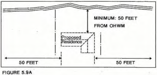
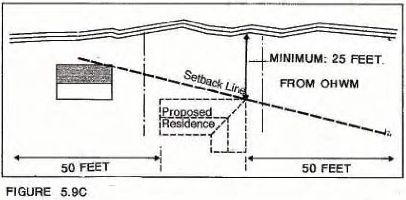
Shoreline Setback: Unless otherwise excepted under DR-5.9.8 or DR-5.9.10, permanent buildings and structures including common appurtenant structures such as garages, decks over 30 inches above grade, and workshops, shall be set back a minimum of fifty- (50) feet from the ordinary high water mark. Setbacks are measured landward, on a horizontal plane, perpendicular to the shoreline. Provided that the setback may be further increased to retain a 15-foot setback from a critical areas buffer associated with the presence of a wetland, geologically hazardous area, or critical fish and wildlife habitat area. Critical areas buffers are established in Chapter 6 Environmental Protection. |
a Infill of Existing Platted Lots - Where there are existing dwellings within 50 feet on either side of the proposed building footprint, the setback may be reduced to the average setback of those dwellings but shall be no less than 25-feet from the OHWM (see Figure 5.9.B). In those instances where a single dwelling unit is within 50 feet of one side of the proposed building footprint, the average setback shall be the difference (average) between the required setback and that of the existing structure (see Figure 5.9C) but shall be no less than 25-feet from the OHWM. In both cases, the existing dwellings are construed to be those that are currently occupied. The mere presence of shacks, sheds or dilapidated buildings does not constitute the existence of a dwelling unit.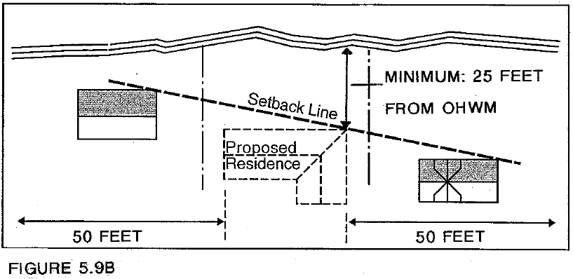
b. Where a residential setback was established as part of the approval of a residential subdivision, the established subdivision setback shall take precedence.
Provided that in either case, the setback exceptions in a. and b. shall not result in a shoreline setback that is less than any critical areas buffer required under Chapter 6, Environmental Protection.
|
DR-5.9.8 |
Exceptions from the Shoreline Residential setback include: Note: To demarcate areas of potential hazard atop a bluff, fencing may be permitted within the residential setback and within the critical areas setback of a steep/marine bluff top. Fencing within the setback shall be of open design and not taller than three feet. Footings shall be designed and placed in a manner that does not decrease slope stability. It is recommended, and the City may require, that property owners consult with their engineer to examine the bluff edge for cracks or failures prior to construction of the fencing. In general, footings should be no closer than ten feet from the edge of the bluff and the smaller and shallower the post hole, the better. |
|
DR-5.9.9 |
Deviations from the required setback shall be reviewed on an individual basis. A request for a deviation shall be considered a variance following the procedures established under Section 10.7 and will be subject to the variance review criteria established under Subsection 10.7.4 of this Master Program. |
|
DR-5.9.10 |
Developments associated with scientific, historical, cultural, educational research uses, public access, low-moderate intensity water oriented recreation open to the general public and ecological restoration are not required to meet the setback requirement. However, where such development may be approved within the setback, the placement of structures, storage, and hard surfaces shall be limited to the minimum necessary for the successful operation of the use. |
|
DR-5.9.11 |
Removal of vegetation and topsoil is strictly regulated under the Clearing, Grading and Vegetation Management Provisions of Chapter 9. |
Design Elements
|
DR-5.9.12 |
For all residential development within shorelines jurisdiction, the area of impervious surfaces (including parking areas but excluding required right- of-way improvements) to be developed within shorelines jurisdiction shall be limited by the slope of the lot as specified in the following table. In no case shall total impervious area exceed 5,000 square feet for any one single-family detached dwelling and accessory structures (i.e., when a single-family home is proposed over multiple lots the total impervious area must not exceed 5,000 square feet)1. |
|
Slope |
Impervious limit (expressed as a percentage of actual land area) |
|---|---|
|
15% or less |
30% |
|
15-30 |
25% |
|
Greater than 30% |
20% |
Areas waterward of the Ordinary High Water Mark and areas of marine bluffs, steep slopes, and wetlands shall not be included to calculate land area. For example, only the buildable area landward of the marine bluff edge shall be used in the calculation.
|
DR-5.9.13 |
The shoreline administrator may grant a waiver, limited to the maximum lot coverage requirements under Title 17 PTMC, when compliance with the impervious limitations of this section would violate constitutional or statutory requirements. |
|
DR-5.9.14 |
A minimum of fifteen percent (15%) of the total lot area shall be retained or replanted in native vegetation. Areas to be retained shall include the largest contiguous, and/or most waterward blocks of native vegetation located on site. If no areas of native vegetation remain, the vegetation retention area shall be replanted with species native to shoreline areas of the Quimper Peninsula. For additions and expansions of existing developments, replanting shall be commensurate with the degree of impact resulting from the new development. |
5.10 Urban
Existing and planned uses in the Urban designation represent a variety of water oriented and non-water oriented uses. Current zoning (C-II, General Commercial) allows for retail businesses, professional offices, hotels, restaurants, personal service shops, recreational uses, and upper-story residential uses. Emerging real estate, business service and office uses are interspersed with multi-family structures and hotels. The Port Townsend-Keystone state ferry terminal is included in this designation.
Vehicles entering and exiting the ferry terminal mix with local traffic on Sims Way (State Route 20) creating significant traffic pressures on this two-lane highway. Opportunities to improve the highway are limited by natural topography and the built environment. Between Kearny Street and the ferry terminal, the close proximity of both the bluff and existing structures to pedestrian and vehicular traffic discourages the development of this area as a specific destination. However, significant water views and the bluffs provide a unique aesthetic quality to this area.
This shoreline has been heavily modified and shoreline functions are impaired. Restoration efforts should be encouraged through various incentives such as factoring “restoration” in as a water-dependent use in a mixed-use project.
Purpose
The purpose of the Urban Designation is to provide for commercial and recreational uses, limited residential and transient uses and public land uses while seeking opportunities for protection and restoration of ecological functions. Because few water-dependent or water-related uses are appropriate in this location, to be consistent with the policy of the Act, shorelines within the Urban designation should be used in ways that enhance ecological functions and/or provide opportunities for the public use and enjoyment of this shoreline.
Designation Criteria
The Urban Designation is appropriate for areas that currently support or are planned for general commercial development. The Urban Designation is located landward of the ordinary high watermark.
Areas Designated
Description
The Urban designation includes:
a. Areas east of Boat Haven Marina and west of the downtown Historic Overlay District, landward of the ordinary high water mark.
b. Kah Tai Care Center on the east side of Kah Tai Lagoon.
Rationale
These areas are zoned for commercial uses and existing land use consists of commercial and high intensity residential uses.
Management Policies
Uses
|
Policy 5.10.1 |
Give priority to water-oriented uses over non-water-oriented uses. |
|
Policy 5.10.2 |
Encourage uses that enhance ecological functions and/or enhance opportunities for the public use and enjoyment of this shoreline. |
Design Elements
|
Policy 5.10.3 |
Coordinate and design uses in this area to be compatible with existing and future ferry operations (e.g. navigation and circulation patterns should be coordinated). |
|
Policy 5.10.4 |
Ensure that, where applicable, improvements within this district are reviewed for compatibility and consistency with the C-II Design Standards codified in the PTMC zoning code and, for project’s fronting SR-20, the design recommendations in the Gateway Development Plan. |
|
Policy 5.10.5 |
Encourage designs that incorporate conservation and restoration elements, such as restoration of intertidal habitat, shoreline vegetation, and enhancement of public access. |
|
Policy 5.10.6 |
Require, where applicable, new development and/or redevelopment to include environmental cleanup (e.g., removal of contaminated soils) and restoration of the shoreline in accordance with state and federal requirements. |
Public Access
|
Policy 5.10.7 |
Protect view corridors identified in Appendix B through appropriate design (e.g., modulation of building heights and massing) of new development. Designs shall protect views of the water and the bluff as viewed from onshore and from offshore. |
|
Policy 5.10.8 |
Seek a public pedestrian walkway system along the Urban waterfront utilizing a combination of natural beaches, pathways, piers, wharves, street-ends, sidewalks, stairways, or other improvements. Although it may not be feasible for the walkway system to be continuous throughout the entire area, it should promote quality pedestrian access to and along major portions of the waterfront. The street-ends of Thayer, Decatur, Kearney, Gaines, Scott, Walker, and Calhoun Streets should, at a minimum, become developed access points to the shoreline. Linkage between these street- ends should be determined by the physical characteristics of the shorelines, existing development patterns, potential for structural improvements, and other factors relevant to developing a continuous pedestrian system. |
|
Policy 5.10.9 |
Encourage designs that enhance pedestrian traffic without impeding vehicular traffic through the use of paving textures, fencing, landscaping, and signage that makes a greater distinction between automobile traffic and pedestrian circulation systems. |
|
Policy 5.10.10 |
Ensure that new development acknowledges and continues the continuity of the street facade and the predominance of ground-level street-front retail bays along Water Street and encloses or otherwise conceals parking facilities. |
Development Regulations
Uses
|
DR-5.10.1 |
The following are prohibited in the Urban Designation: |
a. Aquaculture unless associated with an approved restoration project
b. Industrial uses
c. Warehouse, storage and mini-storage
d. Auto, truck, trailer and recreational vehicle rental, towing, servicing, repair or sales
e. Major recycling facilities
f. Radio and television towers as a primary use
|
DR-5.10.2 |
Development that can be classified as a water-dependent, water-related or water-enjoyment use shall be permitted unless specifically prohibited. |
|
DR-5.10.3 |
A limited range of non-water-oriented development, open to the general public, while not preferred, may also be authorized as a conditional use provided said development: |
a. Conforms with the criteria set forth for conditional uses in Chapter 10;
b. Use is compatible with adjacent water-oriented uses;
c. Is designed and located in manner that capitalizes on shoreline views and is compatible with water-oriented uses; and
d. Makes provisions for the public access and enjoyment consistent with this Master Program.
|
DR-5.10.4 |
Multi-family residential or transient accommodation (hotel and motel) uses may be permitted as a conditional use provided they meet the requirements for non-water oriented uses listed above and further that said use meets the following terms:
|
a. Public access and enjoyment shall be the primary design consideration. Private and public space shall be appropriately separated through sensitive design.
b. A maximum of 50% of total floor area may be devoted to residential and/or transient accommodations unless waived by Section G below.
c. The remaining 50% of total floor area must be either all water- oriented or a mix of water-oriented and certain non-water oriented uses as follows:
i. No less than 25% of the total floor area of the development shall be devoted to water-oriented uses except as provided for in DR 5.10.4(g) below.
ii. The remaining 25% of the total floor area shall be devoted to non-water oriented uses accessible to the general public (e.g., retail, personal services, recreational and cultural uses) excluding transient accommodations.
d. Uses may be placed in either a horizontal arrangement (e.g., commercial on ground floor with residential above) or a vertical arrangement either attached or detached within close proximity (e.g., commercial and residential buildings placed within 25-feet of each other). Regardless of use, the ground floor of all buildings shall have a minimum clear ceiling height of twelve feet in order to allow flexibility of use. (Ord. 2982 § 23, 2008).
e. Development shall comply with the applicable design standards and review processes set forth in Chapter 17 PTMC (e.g., Chapter 17.36, Multifamily Residential Development Standards and Chapter 17.44 Commercial and Mixed Use Architectural and Site Design Standards).
f. Residential and transient accommodation uses must not intrude on the public’s use and enjoyment of the shoreline:
i. Building designs that step back from the public area are encouraged (e.g., upper floors step back from the public area).
ii. Where residential or transient accommodations are situated on the ground-floor:
1.) A minimum vegetated buffer of ten feet shall be included in the dedicated public access easement. This buffer shall be placed between the private and public space;
2.) Residential/transient structures shall be set back 15- feet from the nearest edge of the public access easement and separated by a small hedge, picket fence, wall, or other similar visual separation not exceeding 36-inches in height (walls incorporating seating are encouraged); and,
3.) The ground floor shall be a minimum of three-feet above the grade level of the adjacent public areas to avoid direct sight lines from public space into private areas. (See Figure 5.10A).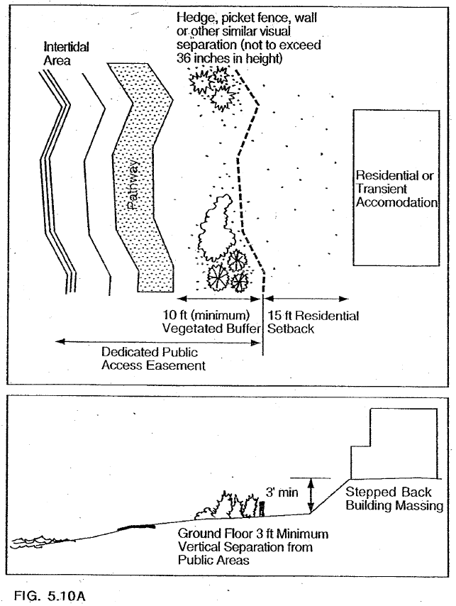
g. Restoration/Public Access Incentive - The requirement in DR 5.10.4(c)(i) above, regarding dedication of no less than 25% of the total floor area to water-oriented uses, may be waived in whole or in part when the proposal provides restoration of ecological functions, habitat enhancement, and/or provision of public access improvements (e.g., parks, esplanades, etc.) that constitute a significant public benefit beyond that which would be required as mitigation for the development. (Thus allowing for an additional 25% of residential/transient or non-water oriented uses accessible to the general public).
In addition to the Conditional Use-approval criteria, the following criterion shall apply:
i. The proposal will provide "greater public benefit" consistent with this Master Program without additional probable significant adverse impacts to public health, safety or the environment, that cannot be adequately mitigated.
ii. Items that may constitute a "greater public benefit" include:
1.) Preservation of critical shoreline habitat,
2.) Restoration of impaired ecological functions,
3.) Dedication to the city of land for a public park or open space,
4.) Preservation of scenic resources, and
5.) Enhanced public access amenities.
iii. On-site restoration shall be preferred. Additional credits may be earned through off-site restoration that occurs within the City. In either case, the applicant must demonstrate, to the satisfaction of the Shoreline Administrator, that the restoration site will be protected in perpetuity: This may be accomplished through various means including but not limited to dedication of a permanent easement to the City or City-approved nonprofit entity; with perpetual protection of easement purposes and reversion to the City if the non-profit cannot maintain the easement, and/or participation in a publicly sponsored restoration or enhancement program.
iv. To assist in determining "greater public benefit" and proportionate development credits, staff shall convene an ad hoc committee to participate in the mandatory pre-application conference and to comment on the formal application. The ad-hoc committee shall include but not be limited to individuals with the following expertise:
a. For ecological restoration, a representative from Washington State Fish and Wildlife, Department
a. of Ecology, and a City resident with expertise in marine/wetlands ecology, plus at least two additional citizens of Port Townsend.
b. For public access, a representative from Department of Ecology, the City’s Non-Motorized Transportation Committee, and the City’s Parks and Recreation Committee plus at least two additional citizens of Port Townsend.
The committee’s recommendation shall be included in the staff report to the Hearings Examiner.
|
DR-5.10.5 |
Additional allowed, conditional, and prohibited uses for the Urban Designation are listed in Table 5 at the end of this Chapter. |
Design Elements
|
DR-5.10.6 |
New development within the Urban District shall comply with applicable design guidelines for the Historic Overlay District-Design Review or the Commercial and Mixed Use/Multi-family Architectural and Site Design Standards as codified in the Port Townsend Municipal Code. Improvements westerly of the ferry terminal shall also comply with the design guidelines of the Gateway Development Plan. |
Height Limitations
|
DR-5.10.7 |
New or expanded structures within the Special Height Overlay District are subject to the specific height limits of the Special Height Overlay District codified in Chapter 17.28 of the Port Townsend Municipal Code (see Appendix C). |
|
DR-5.10.8 |
New or expanded structures outside of the Special Height Overlay District shall be limited to a maximum height of 40-feet. (Ord. 2982 § 23, 2008). |
Setbacks
|
DR-5.10.9 |
Permanent buildings and structures shall be set back a minimum of twenty-five (25) feet from the ordinary high water. Setbacks are measured landward, on a horizontal plane, perpendicular to the shoreline. |
|
DR-5.10.10 |
Developments associated with water-dependent scientific, historical, cultural, or educational research uses, public access, water-oriented recreation and ecological restoration are not required to meet the setback requirement. However, where such development may be approved within the setback, the placement of structures, storage, and hard surfaces shall be limited to the minimum necessary for the successful operation of the use. |
5.11 Historic Waterfront
The Historic Waterfront is the historic commercial area of downtown Port Townsend. This area includes many non-water-oriented commercial uses as well as historic structures that have been built on fill placed in the shoreline area.
Existing land uses include specialty shops and services, upper floor residential, restaurants, hotels, government offices, cultural resources, community-oriented buildings, public recreational uses and open space. On-street parking is also a dominant visual feature of the area.
The development patterns of Port Townsend’s historic downtown were predicated on the orientation of buildings located along the shoreline towards Water Street. The absence of adequate access to the rear of these buildings is evidenced by the loading/unloading of commercial deliveries from the center of Water Street. This lack of rear access also hinders the adaptive reuse of historic buildings as modern building codes require two-points of egress for life-safety for most uses. As noted in Section 5.6 Aquatic, the City is committed to maintaining the continued viability of historic buildings along the shoreline. The establishment of an over- water walkway or multiple walkways that allow for emergency egress is a key component towards maintaining this viability.
Purpose
The purpose of the Historic Waterfront Designation is to protect historic resources, provide for continued commercial uses that are consistent with the historic character of the area, including those that are not water-oriented, while protecting existing ecological functions, restoring ecological functions in areas that have been previously degraded, and enhancing public access to the shoreline. The Historic Waterfront is an ideal area to encourage water-enjoyment uses.
The following identifies the objectives for the Historic Waterfront Designation in order of importance:
a. Protect the historic resources of Port Townsend while minimizing the impact to critical areas and natural shoreline processes;
b. Accommodate the functional re-use of historic structures; and
c. Ensure that the impacts associated with the continued use of historic structures on the shoreline results in no net loss of ecological functions.
Designation Criteria
The Historic Waterfront Designation is the area within the National Landmark Historic District largely occupied by the collection of historic late 19th-century brick and stonework commercial buildings.
Areas Designated
Description
The Historic Waterfront designation includes areas landward of the ordinary high water mark that are within the C-III Historic Commercial zoning district.
Rationale
This is a collection of historic buildings, in a designated Landmark Historic District, that provide the commercial and social center of Port Townsend.
Management Policies
Uses
|
Policy 5.11.1 |
Encourage a mixture and variety of uses and activities in the Historic Waterfront Designation, particularly those that:
|
a. Preserve and restore the historic character of Port Townsend.
b. Support and reinforce the design and architectural qualities of the Water Street National Historic District when located within or adjacent to its boundaries.
c. Provide an opportunity for the public to actively or passively enjoy the community’s waterfront amenity.
d. Provide a physical link or connection open to the public between the upland and the shoreline.
e. Are water-oriented uses or are accessory to, complimentary to or support water-oriented uses.
f. Enhance the character and flavor of the Port Townsend urban waterfront.
|
Policy 5.11.2 |
Maintain and enhance the historic waterfront character of the district by prohibiting incompatible uses and requiring compliance with historic district design review standards. |
|
Policy 5.11.3 |
Encourage rehabilitation, renovation, and adaptive reuse of upper floors of historic buildings (e.g. for artist studios, permanent housing, and office space) so as to contribute to the vitality of the area. |
Design Elements
|
Policy 5.11.4 |
Allow development only in those areas where impacts and hazards caused by the proposed development can be effectively mitigated and where the environment is capable of supporting the proposed use in a manner that protects ecological functions. |
|
Policy 5.11.5 |
Encourage conservation and restoration projects, such as restoration of intertidal habitat and enhancement of public access. |
|
Policy 5.11.6 |
Protect view corridors identified in Appendix C through appropriate design (e.g., modulation of building heights and massing) of new development. Designs shall protect views of the water and the bluff as viewed from onshore and from offshore. |
|
Policy 5.11.7 |
Ensure that new development provides visual and physical public access, consistent with constitutional and statutory limitations, unless such access is shown to be incompatible due to reasons of safety, security, or impact to the shoreline. In lieu of on-site improvements, the Shoreline Administrator may allow for off-site improvements if said improvements would provide a greater public benefit (WAC 173-26-221 (4)(c) and (d)). |
|
Policy 5.11.8 |
Implement aesthetic objectives by means such as compliance with the City’s sign control regulations (Chapter 17.76 PTMC), appropriate development siting, screening, and architectural standards as implemented through the City’s historic design review standards (Chapter 17.30 PTMC), and locally appropriate landscaping. |
|
Policy 5.11.9 |
Seek a public pedestrian walkway system along the Historic Waterfront Designation utilizing a combination of natural beaches, pathways, piers, wharves, street-ends, sidewalks, stairways, or other improvements. Although it may not be feasible for the walkway system to be continuous throughout the entire area, it should promote quality pedestrian access to and along major portions of the waterfront. The street-ends of Tyler, Adams, Quincy, and Monroe Streets should, at a minimum, become developed access points to the shoreline. Linkage between these street- ends should be determined by the physical characteristics of the shorelines, existing development patterns, potential for structural improvements, and other factors relevant to developing a continuous pedestrian system. |
|
Policy 5.11.10 |
Implement ecological and aesthetic objectives by restoring native shoreline vegetation where feasible, including at developed street ends and/or public shoreline access points. |
Development Regulations
Uses
|
DR-5.11.1 |
The following are prohibited in the Historic Waterfront Designation: |
a. Aquaculture unless associated with an approved restoration project
b. Industrial uses
c. Warehouse, storage and mini-storage
d. Auto, truck, trailer and recreational vehicle rental, towing, servicing, repair or sales
e. Major recycling facilities
f. Radio and television towers as a primary use
|
DR-5.11.2 |
Unless otherwise prohibited by this Chapter, development that can be classified as a water-dependent, water-related or water-enjoyment use shall be permitted provided that the development is designed and operated in a manner that is compatible with the character of this Landmark Historic District. |
|
DR-5.11.3 |
Non-water-oriented development may also be permitted provided said development is designed and located in a manner compatible with the Landmark Historic District and water-oriented uses and, furthermore, that said development makes provisions for the public access and enjoyment consistent with this Master Program. |
|
DR-5.11.4 |
Residential or transient accommodations (hotel and motel) are primary uses and may be allowed as a permitted use, provided that each of the following conditions is met. a. Residential and transient accommodations shall not occupy any portion of the ground floor of any buildings. Accessory uses, such as lobbies, which provide services or access to residential or transient accommodations are allowed on the ground floor. b. The ground floor shall be reserved on a continuous basis for commercial retail or service uses open to the general public and permitted by the underlying zoning. |
|
DR-5.11.5 |
Additional permitted, conditional and prohibited uses for the Historic Waterfront Designation are listed in Table 5 at the end of this Chapter. |
|
DR-5.11.6 |
Improvements within the Historic Waterfront are subject to design review to ensure compliance with the design guidelines for the Historic Overlay District as codified in the Port Townsend Municipal Code. |
|
DR-5.11.7 |
New structures or exterior alterations of existing structures shall not detract from the design and architectural integrity of the Water Street Historic District. Plans for development shall include exterior elevations with enough design details to be evaluated by appropriate historic preservation agencies. |
|
DR-5.11.8 |
New uses and developments must demonstrate consistency with the Historic Waterfront management policies of this master program |
Height Limit
|
DR-5.11.9 |
New or expanded structures are subject to the specific height limits of the Special Height Overlay District codified in Chapter 17.28 of the Port Townsend Municipal Code (see Appendix C). |
Setbacks
(For restoration of existing non-conforming buildings, see Chapter 11.)
|
DR-5.11.10 |
Water-dependent uses require no setback. All other new development shall be setback a minimum of 25-feet from the ordinary high-water mark with the following exceptions: a. Interconnected walkways that facilitate a second point of egress to achieve life/safety code compliance to facilitate adaptive reuse of shoreline buildings shall be permitted in cases where no feasible alternative exists. Although the primary purpose of these walkways shall be to facilitate emergency egress, opportunities for their use to enhance public access along the shoreline shall be evaluated and where appropriate, permitted. Elevated walkways and decks shall not inhibit public access to or use of the beach unless no other alternative exists for meeting life/safety codes. b. Decks and balconies may be permitted on upper floors, provided that the applicant can demonstrate that the proposed improvements will not adversely impact public use of the shoreline or the ecological functions, values, and resources of the shoreline. |
5.12 Boat Haven Marina and Marine Trades District
The Boat Haven Marina and Marine Trades District (the "Boat Haven District") is a district that encompasses commercial and recreational moorage for about 400 boats, as well as predominantly water-oriented industrial, commercial and retail structures and uses. A section of the Larry Scott Memorial Trail also lies within this District. The Boat Haven marina, owned and operated by the Port of Port Townsend, is a 19-acre rectangle surrounded by a riprap breakwater. Benedict Street Spit separates the existing in-water moorage at Boat Haven into two basins. One privately owned parcel lies within the Port-owned properties at the Boat Haven.
The northeastern basin, approximately 4-acres in size, serves water-dependent commercial operations with moorage for approximately 50 vessels. In the mid- 80s, the northeast basin was home to approximately 50 commercial fishing vessels. Market conditions have caused that number to dwindle to approximately 10 commercial fishing vessels today, resulting in increased recreational vessel use of the northeastern basin. The northeast basin is a transitional area that serves as a gateway between the urban waterfront commercial uses to the east, and the water-dependent and water-related marine trades uses in the main basin.
The majority of the recreational moorage and water-dependent and water-related commercial facilities within the district are located in the approximately 15-acre main basin situated on the southwestern side of the Benedict Street Spit, where approximately 350 vessels are moored. There is an existing fuel float, sanitary pump-out facility, and transient moorage float adjacent to the Benedict Street spit, as well as a public boat launch.
Prior to development, the entire Boat Haven area, including areas that now lie outside the shoreline jurisdiction, was a small bay that adjoined Port Townsend Bay. Significant filling beginning in the 1800’s created the present upland area known as Boat Haven Industrial Park. Uplands areas within the shoreline jurisdiction are used primarily for water-related uses including: boat storage, boat building, repair, sales and service; a commercial fish processing operation, a yacht club; a U.S. Coast Guard station, and marine-related offices and manufacturing.
Some of the water-enjoyment and non-water-oriented uses at the Boat Haven occur outside the 200 foot shoreline jurisdiction, and include a wide range of uses including: a restaurant; offices; manufacturing; a County household hazardous waste facility; and an assortment of other commercial retail and professional businesses. Current zoning allows for small restaurants of up to 1,500 square feet.1 A number of these upland uses are nonconforming (as of 2005) under the marine-related manufacturing (M-II(A)) zoning which is applied to upland portions of the Port’s property at the Boat Haven. Though also applied to areas outside the shoreline jurisdiction, the 2005 M-II(A) zoning district states that it is intended for larger scale and more intensive water-dependent and marine-related uses.
The Port of Port Townsend plans a deep-water expansion of the marina. Approximately 200 new slips would be added. A new work pier and docks would be constructed in the expanded basin. The Port’s preferred alternative is a deep- water expansion and upland redevelopment alternative for the marina expansion. It should be acknowledged, however, that additional input from the U.S. Army Corps of Engineers, as well as the National Marine Fisheries Service (NMFS), could result in changes to the preferred alternative (please refer to alternative #2, page III-18-22, and Figure 3-2 within the Comprehensive Scheme of Harbor Improvements Update 2003 & Environmental Impact Statement: December 2, 2003).
Purpose
The overall purpose of the Boat Haven Marina and Marine Trades District is to provide for a variety of water-oriented uses, with a primary focus on water-dependent and water-related activities and uses including recreational boating, manufacturing, assembly, haul out and repair. It is intended to support larger scale and intensive water-dependent or marine-related uses and activities that are critical to maintaining and building upon Port Townsend’s marine trades businesses. Though the district’s focus is upon water-dependent and water-related activities, an appropriate mix of water-enjoyment and limited non-water-oriented uses is appropriate within the northeastern portion of the district to serve as a transitional gateway between the urban waterfront commercial uses to the east, and the water-dependent and water-related uses in the remainder of the Boat Haven.
Designation Criteria
The Boat Haven Marina and Marine Trades District is that area that is used for or designated as marine-related, high intensity commercial and industrial uses, or areas suitable or planned for high-intensity water-dependent and water-related uses necessary to commerce, transportation, boat-building or navigation at the Boat Haven Marina. These areas reflect the following characteristics:
a. Land which is either currently accommodating high-intensity commercial or industrial uses or is designated for such uses;
b. Significant modifications to the shoreline have occurred;
c. Existing or proposed high-intensity commercial or industrial uses;
d. Few environmental limitations to development are present, such as steep slopes, or landslide hazard areas.
Areas Designated
Description
The Boat Haven Marina and Marine Trades District includes:
The developed shoreline and harbor areas of the Boat Haven Marina, from outer jetty inland, but not past Washington, Jefferson or Benedict Streets. The district also includes areas east to Thayer Street. The western boundary of the district lies at the end of intense development and does not include the adjacent natural and wetland areas owned by the Port of Port Townsend.
Rationale
This is an established marina operated by the Port of Port Townsend and used for recreational, commercial and industrial marine activities.
Management Policies
|
Policy 5.12.1 |
In regulating uses in the Boat Haven District, distinguish between the main boat basin and the northeast boat basin areas as follows: |
a. Prohibit water-enjoyment and non-water-oriented uses within the main boat basin. First priority should be given to water-dependent uses, second priority to water-related uses, and third priority to public access uses (i.e., including associated facilities such as public restrooms, benches and signage).
b. Within the northeast boat basin, first priority should be given to water-dependent, water-related, and water-enjoyment uses (including public access uses), second priority to non-water-oriented uses combined with water-dependent or water-related uses, and third priority to a limited range of non-water-oriented use as specified in Table 5.12-1.
|
Policy 5.12.2 |
Provide for high-intensity water-dependent and water-related commercial and industrial uses within the Boat Haven District, while protecting existing ecological functions. Non-water-dependent industrial uses should be located outside the shoreline jurisdiction |
|
Policy 5.12.3 |
Preserve and protect existing water-dependent and water-related uses, especially marine trades, as critical elements of the traditional and current economy of the city, as well as elements that define the character of the community. |
|
Policy 5.12.4 |
Permit as conditional uses water-enjoyment uses and a limited range of non-water-oriented uses within the northeastern basin subdistrict as described in the "Uses and Subdistricts" section of this chapter, provided that such uses are found to be compatible with, and supportive of, preferred water-dependent and water-related uses. This policy is intended to acknowledge the existence of a transition zone between the urban waterfront district lying to the east of Thayer Street and north of Washington Street, and the more intensive water-dependent and water- related industrial uses within the main basin sub-district. |
|
Policy 5.12.5 |
Permit water-enjoyment public access uses (i.e., including associated facilities such as public restrooms, benches and signage) as third priority uses within the main boat basin, and first priority uses within the northeast boat basin, consistent with management policy 5.12.1, above. |
|
Policy 5.12.6 |
Maintain the existing, and expand the future, base of water-dependent and water-related industrial activities within the Boat Haven District, particularly in those areas lying in the main basin sub-district. |
|
Policy 5.12.7 |
Support the Port’s preferred alternative for the proposed marina expansion by including the deep-water expansion area in the map designation for the Boat Haven District. Work with the Port to foster a marina expansion and upland development that achieves the goals of the priority uses for the Boat Haven District and supports the long-term viability of marine trades. |
|
Policy 5.12.8 |
Encourage the Port to manage liveaboards situated within the marina in a manner that ensures the use: |
a. Will not result in the marina exceeding federal or state water quality standards;
b. Will meet the “no net loss” policy for ecological functions; and
c. Will not inhibit the long-term viability of priority uses (i.e., water-dependent and water-related uses).
Design Elements
|
Policy 5.12.9 |
Locate, design, construct and operate industrial and port facilities to minimize unnecessary conflicts with and impacts to adjacent, non- industrial land or water uses to the extent practicable, given the intended use and zoning as a Port industrial facility. |
|
Policy 5.12.10 |
Preserve water-dependent and water-related uses, enhance publicly oriented recreational uses along the shoreline, and foster compatible marine-related uses in adjacent upland areas of the Boat Haven. |
|
Policy 5.12.11 |
Require new development to provide physical and visual access to shorelines whenever possible and consistent with constitutional and statutory limitations, provided such access does not interfere with industrial operations or endanger public health and safety. In lieu of on- site improvements, the Shoreline Administrator may allow for off-site improvements if said improvements would provide a greater public benefit (WAC 173-26-221 (4)(c) and (d)). |
|
Policy 5.12.12 |
Maximize efficient use of areas within the Boat Haven District for water-dependent and water-related uses before contemplating expansions to the district. Ensure that any future expansions to the district are subject to adequate environmental review, and that identified impacts are fully mitigated to achieve "no net loss" of environmental functions and values. |
|
Policy 5.12.13 |
Promote compatibility with the priority uses within this district. Encourage the Port of Port Townsend to give first priority to water-oriented uses when leasing spaces or areas immediately adjacent to the shoreline jurisdiction. |
|
Policy 5.12.14 |
Allow uses that adversely impact the ecological functions of critical saltwater and freshwater habitats only where necessary to achieve the objectives of RCW 90.58.020 (Legislative findings—State policy enunciated – Use preference), and then only when their impacts are mitigated according to the sequence described in WAC 173-26-201(2)(e) as necessary to assure "no net loss" of ecological functions. Where applicable, new development shall include environmental cleanup and restoration of the shoreline in accordance with state and federal requirements consistent with constitutional or statutory limitations on the regulation of private property. |
|
Policy 5.12.15 |
Work with the Port to identify opportunities for restoration and encourage conservation in the Boat Haven Marine Trades environment, such as preservation of water quality and enhancement of public access. |
Over-water Structures
|
Policy 5.12.16 |
Allow new over-water structures only for water-dependent uses, public access, or ecological restoration. |
|
Policy 5.12.17 |
Minimize environmental impacts of new overwater structures within the marina through selection of appropriate design and materials. |
Environmental Protection
|
Policy 5.12.18 |
Design and manage shoreline uses and modifications within the Boat Haven designation consistent with the Environmental Protection policies and regulations of Chapter 6 including, but not limited to, preservation of water quality, natural hydrographic conditions, and safe, unobstructed passage of fish and wildlife, particularly those species dependent on migration. |
Development Regulations
Uses and Sub-Districts
|
DR-5.12.1 |
Only water-dependent uses, public access, or ecological restoration shall be permitted on new over-water structures. |
|
DR-5.12.2 |
Recognize the different characters of the Boat Haven’s two sub-districts:
|
a. Main Boat Basin Sub-District (See Shorelines Designation Map Appendix A). This area includes the areas within the shoreline jurisdiction from 75 feet west of the Benedict Street right-of-way west to the end of the developed portion of the Port property, and encompasses the approximately 15-acre main boat basin that provides moorage primarily for recreational boaters. This area also encompasses the majority of the water-dependent and water-related commercial and industrial uses and activities occurring at the Boat Haven. Uses are prohibited, permitted, or may be conditionally permitted within the main boat basin sub-district as follows:
i. The following uses are prohibited:
1.) Residential (except liveaboards in the existing marina, which are a permitted use, subject to Port policy and state and federal regulations);
2.) Transient accommodations (hotel and motel).
ii. The following uses are permitted:
1.) Water-dependent uses;
2.) Water-related uses; and
3.) Public access uses provided that they shall be designed and located to be compatible with the operation of the Boat Haven marine-trades.
4.) Though not preferred, a small-scale marina-serving grocery/deli (i.e., not exceeding 1,500 gross square feet) may be permitted conditionally within the main boat basin sub-district, if found to be compatible with, and beneficial to, preferred uses within the sub-district.
b. Northeast Boat Basin Sub-District (See Shorelines Designation Map Appendix A). This area includes the areas within the shoreline jurisdiction from 75 feet west of the Benedict Street right-of-way eastwards to Thayer Street, and encompasses the approximately 4 acre northeast boat basin that serves commercial fishing operations as well as recreational boaters. Principal existing uses lying waterward of the OHWM within this sub-district include: Port offices on the west side of Benedict Street; a commercial fish processing operation; a yacht club; and a restaurant. Uses are prohibited, permitted, or may be conditionally permitted within the northeast boat basin subdistrict as follows:
i. The following uses are prohibited:
1.) Residential (except for liveaboards, which are a permitted use, subject to Port policy and state and federal regulations); and
2.) Transient accommodations (hotel and motel).
ii. The following uses are permitted:
1.) Water-dependent uses;
2.) Water-related uses;
3.) Water-enjoyment public access uses, provided that they shall be designed and located to be compatible with the operation of the Boat Haven Marina; and
4.) Other water-enjoyment uses, provided that water- enjoyment restaurant uses shall be limited to a total of 2 (not to exceed 3,500 square feet per restaurant or a combined total of 5,000 s.f.), and provided further that any such restaurant use be designed to take advantage of shoreline views and incorporate outdoor seating areas that are compatible with shoreline public access.
iii. The following uses may be permitted conditionally, provided that they are not incompatible with the preferred uses within the subdistrict:
1.) One marina-serving grocery/deli, not to exceed 1,500 s.f., designed primarily to serve marina users and employees;
2.) One non-water-oriented business/professional office located on the west side of Benedict Street (not to exceed 1,500 gross square feet); and
3.) Non-water-oriented uses as part of a development which also includes water-dependent or water-related uses, provided non-water-oriented uses do not exceed 20% of the gross square footage of the development, and provided further that they are compatible with adjacent water-oriented uses and public access improvements. Although water-enjoyment uses (subject to the limitations of this section) may be included in the mix, water-dependent or water-related uses are required as part of the development.
Height Limit
|
DR-5.12.3 |
No new or expanded building or structure shall exceed a building height of thirty-five (35) feet. |
|
DR-5.12.4 |
There is no specific setback from the ordinary high water mark (OHWM) of the marina. From the OHWM of Port Townsend Bay, the setback shall be a minimum of twenty-five (25) feet for non-water-dependent uses or, as needed to preserve/provide public access whichever is greater |
|
BOAT HAVEN MARINA & MARINE TRADES DISTRICT: SHORELINE ENVIRONMENT DESIGNATION |
|||
|---|---|---|---|
|
Standards & Uses |
Main Boat Basin Sub-District |
Northeast Boat Basin Sub- District |
Applicable Regulations/Notes |
|
Development Standard: |
|
|
|
|
Setbacks from OHWM for nonwater-dependent uses1 |
0 from marina; 25 ft. from PT Bay |
Same as Main Boat Basin Sub-District |
None. |
|
Height Limit |
35 ft. per RCW |
|
|
|
Specific Shoreline Uses: |
|
|
|
|
Advertising Signs |
P |
P |
Section 8.2 and as further regulated by Chapter 17.76 PTMC “Signs” |
|
Agriculture |
X |
X |
None. |
|
Aquaculture: |
|
|
|
|
• For Restoration; |
P |
P |
Section 8.3. |
|
• Mechanical Geoduck Harvest2 |
N/A |
N/A |
|
|
• Seafood Culturing, Harvesting and Processing |
P (uplands) |
P (uplands) |
Related minor improvements within the adjacent Aquatic designation necessary to support the upland aquacultural use shall also be permitted (e.g., small scale water intakes and clean water outfalls). |
|
Artwork |
|
|
|
|
• Major |
P |
P |
|
|
• Minor |
P |
P |
|
|
Boat Launches |
P |
P |
Section 8.5. |
|
Shoreline Commercial Uses - Generally3: |
|||
|
• Water-dependent commercial; |
P |
P |
See DR 5.12.2 |
|
• Water-related commercial; |
P |
P |
|
|
• Water-enjoyment commercial; |
X |
P (See notes) |
(Provided that water-enjoyment restaurant uses shall be limited to 2,and shall not exceed a combined total of 5,000 gross s.f.) |
|
• Non-water oriented commercial |
X |
X(3) |
|
|
Shoreline Commercial Uses - Specific Exceptions: |
|||
|
Business/Professional Offices, Non-Water Oriented |
X |
X (except CU on the west side of Benedict St.) |
See DR 5.12.2 One non-water oriented business/professional office, not exceeding 1,500 gross s.f. may be located on the west side of Benedict St. in the Northeast Basin Sub-District. |
|
Other Non-Water Oriented Uses as Part of Development which also contains water-dependent or water- related uses |
X |
CU |
See DR 5.12.2 Non-water oriented business and professional offices uses may be permitted as part of development which also contains water-dependent or water-related uses within the Northeast Basin Sub-District, provided they do not exceed 20% of the gross s.f. of the development and that they are compatible with adjacent water-oriented uses and public access improvements. |
|
Restaurants, Water- Enjoyment |
X |
P |
See DR 5.12. Water-enjoyment restaurant uses shall be prohibited in the Main Basin Sub-District, and permitted in the Northeast Basin Sub-District, except that their number shall be limited to 2, and shall not exceed a combined total of 5,000 gross s.f. |
|
Marina-Serving Grocery/Deli |
CU |
CU |
See DR 5.12.2 Up to one marina serving grocery/deli, not to exceed 1,500 gross s.f, may be permitted conditionally in each sub-district if found to be compatible with, and beneficial to, preferred shoreline uses. |
|
Docks, Piers and Floats |
P |
P |
Section 9.4 |
|
Dredging: unless otherwise specified below: |
CU |
CU |
Section 9.5 Maintenance dredging may be exempt, however, dredging that alters the location, depth or width of the previously dredged area shall require a new permit. |
|
• Dredging for an existing legally established water-dependent use; |
P |
P |
|
|
• Dredging for approved ecological restoration |
P |
P |
|
|
Dredge Spoil Disposal |
CU |
CU |
Section 9.5. |
|
Industrial and Port Facilities: |
|
|
|
|
• Water-dependent; |
P |
P |
Section 8.7. |
|
• Water-related; |
P |
P |
|
|
• Non-water oriented |
X |
X |
|
|
Landfills |
CU |
CU |
None. |
|
Marinas |
P |
P |
None. |
|
Mining |
X |
X |
None. |
|
Parking: |
|
|
|
|
• Associated with an Approved Use; and |
P |
P |
None. |
|
• As a Primary Use |
X |
X |
|
|
Public Access |
P |
P |
See DR 5.12.2. Public access uses shall be designed and located to be compatible with the operation of the Boat Haven. |
|
Recreation Facilities: |
|
|
See DR 5.12.2. |
|
• Water-Dependent; |
P |
|
|
|
• Nonwater-dependent: |
|
|
|
|
• High Intensity; |
X |
X |
|
|
• Moderate Intensity; |
P |
P |
|
|
• Low Intensity |
P |
P |
|
|
Residential |
X |
X |
See DR 5.12.2. Liveaboards in the existing marina are a permitted use, subject to Port policy and state and federal regulations. |
|
Scientific, Cultural and Education |
P |
P |
Section 8.14 |
|
Shore Defense Works: |
|
|
|
|
• Bulkheads; |
CU |
CU |
Section 9.7. |
|
• Revetments |
CU |
CU |
|
|
Signs Interpretive/Educational |
P |
P |
Section 8.2. |
|
Transportation Facilities: |
|
|
|
|
• Water-Dependent; |
P |
P |
Section 8.15. |
|
• Water-Related; |
P |
P |
|
|
• Water-Enjoyment |
P |
|
|
|
• Non-water oriented |
P |
P |
|
|
• Roads |
P |
P |
|
|
Transient Accommodations (hotel or motel) |
X |
X |
See DR 5.12.2. |
|
Utilities: |
|
|
|
|
• Primary; and |
X |
X |
Section 8.16 |
|
• Accessory |
P |
P |
|
|
P = May be permitted (i.e., allowed) subject to Substantial Development Permit conditions and provisions contained in this Master Program. CU = May be permitted (i.e., allowed) as a conditional use. X = Prohibited N/A = Not applicable |
|||
No setback is required for public access improvements or for water-dependent uses where allowed by the designation.
In DNR tracts only. Prohibited elsewhere.
Refer to "Shoreline Commercial Uses - Specifically" for exceptions.
5.13 Point Hudson Marina District
Point Hudson is an area containing a marina, a portion of the privately owned Fleet Marine, small scale marine trades, water-oriented nonprofit educational facilities, water-oriented retail, restaurants, transient accommodations (including a bed and breakfast, and a hotel), RV camping, and a small number of non-water-oriented offices and artisan-craftsman work spaces all centered around the Point Hudson Marina. Over the past 30 years, Point Hudson has become internationally known as the home of the Port Townsend Wooden Boat Festival and the home of small-scale, high quality marine trades craftsmen and craftswomen. Boat builders, sail makers, kayak retailers, and other marine trades and artisans make Point Hudson a truly unique place, and helped to attract the Northwest Maritime Center. Point Hudson’s proximity to the Northwest Maritime Center offers tremendous opportunity to revitalize the area in keeping with its scale and character. The marina and most of the land at Point Hudson are owned and operated by the Port of Port Townsend. In April of 2002, after having leased it to a private entity since April of 1962, the Port took over operation of the Point Hudson property, which consists of approximately 32 acres of uplands and tidelands.
Most of the buildings in the Point Hudson Marina district date from the 1930’s when Point Hudson was used as a federal quarantine station or from the 1940’s when Point Hudson served as a Coast Guard station and U.S. Army training base (hereafter referred to as the Point Hudson Station Buildings) (Appendix D, Map of Point Hudson Station Buildings). The U.S. Military deeded the majority of the Point Hudson District, including tidelands, to the Port in 1956. Over the years these buildings have served many purposes and their creative adaptive reuse is one of the character defining features of this district. The Point Hudson district is located within the Port Townsend National Landmark Historic District, but none of the buildings is listed on the National Register.
With the ongoing and future planned public access projects, including the 1,400 linear feet of beach trail and the Port’s planned esplanade around the perimeter of the marina basin and northeast shoreline, Point Hudson has shoreline access and view corridors of both the Cascades and the Olympic mountain ranges, and also includes water views of Admiralty Inlet and Port Townsend Bay. Views have also been restored by the Port’s removal of overhead wires, telephone poles and the foghorn. The goal to create new public access and open space, to eventually connect to the esplanade at the Boat Haven Marina, supports the vision in the City’s Urban Waterfront Plan and is reflected in the Comprehensive Scheme of Harbor Improvements Update, adopted by the Port in 2003. The Port is also in the process of the total rehabilitation of the existing marina. Visual access is impacted by the placement of recreational vehicles in the Port operated RV Park. The RV Park provides recreational access to the shoreline to a substantial number of people; however, for the purposes of this master program, RV camping is not considered a water-enjoyment use. Port officials report that net revenues from the RV Park currently keep Point Hudson financially viable, supporting water- oriented development with the income it generates. The City recognizes real improvement to habitat value and ecological function could result from portions of dune areas near the sand spit being restored to more natural conditions, with native species buffer areas to the sand spit established and protected from trampling. The goal is to achieve the ecological restoration of the eastern point.
Purpose
The purpose of the “Point Hudson Marina” environment designation is to provide for a variety of water-oriented uses and other limited uses appropriate to the existence of a traditional small-scale marina, marine trades and artisan and public use of Point Hudson, which create the character of Point Hudson. This designation seeks to promote adaptive reuse of the existing buildings and a mix of water-dependent and water-related uses compatible with the historic character of the district. To promote historic preservation and encourage increased public access and ecological restoration of the eastern point, this district also accommodates a mix of water-oriented uses and other limited uses that promote adaptive reuse and are compatible with the historic, marine-related character of the area.
The Shoreline Management Act’s goals of increasing access to shorelines; preserving scenic vistas; and protecting and restoring buildings, sites, and areas that have historic, cultural, scientific, or educational value are all priority goals in the Point Hudson District.
On December 19, 1994, the City of Port Townsend and the Port of Port Townsend through Joint Resolution 94-148 adopted six goals from the draft Point Hudson Master Plan to guide future planning and development activities in Point Hudson. These joint goals have been incorporated into this Master Program (see General Management Policies (1-6) below).
Designation Criteria
The Point Hudson Marina District environment designation encompasses Port and private properties that are occupied by the Point Hudson marina and associated uses including marine trades, maritime educational use, visitor-serving commercial, recreation and moorage.
Description
The Point Hudson Marina District environment designation (“Point Hudson District”) includes:
1. The area southeast of Hudson Place and east of Jackson Street including the spit and the marina landward of the ordinary high water mark.
2. All of Blocks 93 and the east half of both blocks 52 and 45, Plat of Port Townsend Original Townsite, lying east of Monroe Street and south of Franklin Street landward of the ordinary high water mark.
3. The property that encompasses the Northwest Maritime Center site, Block 4 of the Port Townsend Original Townsite, bounded by Monroe Street to the west and the Point Hudson Marina to the east, including the vacated portions of Water and Jackson Streets.
4. The map of environmental designations contained in Appendix A graphically depicts this district.
Rationale
Point Hudson is an established and historic marina and is used primarily for water-oriented marine trades, limited commercial, maritime educational and recreational activities. The uses in Point Hudson are distinct from the residential uses to the north and the district places an emphasis on water-oriented uses as opposed to the more general commercial uses found in the Historic Waterfront District. The Point Hudson District lies within the Port Townsend National Landmark Historic District.
The primary objectives of this district are to achieve a high level of rehabilitation of existing buildings, renovate the marina, protect and restore shoreline ecological resources, promote shoreline public access and showcase Port Townsend’s maritime history, small-scale marine trades businesses, visitor services and special waterfront character.
The challenge is to find ways to maintain the District’s integrity, character and economic viability to support the needed infrastructure and public improvements without undue gentrification and displacement of marine trades and maritime educational uses.
Management Principles
Development and rehabilitation of existing buildings should be based on the following principles:
1. Allow incremental, evolutionary changes to existing buildings and shoreline uses, starting with current use patterns.
2. Retain long-term opportunities for water-oriented uses, such as increasing marine-oriented uses, educational institutions and public areas.
3. Coordinate long-term planning with the downtown, particularly in the areas of vehicle and pedestrian circulation, visitor access, and achieving a broad spectrum of uses, activities and attractions.
4. Coordinate boating facilities and marine-oriented activities with Boat Haven to maximize opportunities for the recreational and commercial boating community.
5. Recognize that Point Hudson is a unique waterfront site within the northwest and is an important gateway into Port Townsend.
Management Policies
General
|
Policy 5.13.1 |
Pursuant to Resolution 94-148, the following general goals provide the foundation for planning within Point Hudson: |
1. Point Hudson must be financially self-supporting.
2. Protect small-scale nature.
3. Provide a high degree of public access/use.
4. Preserve the historic character.
5. Encourage the marine trades and water-oriented uses.
6. Maintain property in Port/public ownership.
|
Policy 5.13.2 |
Encourage the removal of RVs from Point Hudson, especially on the point, by allowing adaptive reuses in existing buildings and new compatible development that will generate sufficient replacement revenues to the Port to ensure that Point Hudson remains financially self- supporting. As part of the recurrent plan and code review and amendments mandated under the GMA (RCW 36.70A.130), periodically assess the status of Point Hudson and determine whether the use and development regulations for Point Hudson are achieving their desired effect. |
|
Policy 5.13.3 |
Work with the Port of Port Townsend to identify opportunities for restoration such as the Point Hudson sandspit and an appropriate buffer zone for protecting and restoring ecological functions, consistent with the ecological protection and restoration objectives of this Master Program. Removal of pedestrian, domestic animal and automotive intrusions from the area nearest the sand spit would facilitate enhancement of ecological functions of that dynamic feature of the land and sea, and promote protection of avian species like Black Brant geese. |
|
Policy 5.13.4 |
Limit the size and total square footage of restaurants in order to protect Point Hudson’s small–scale character and emphasize marine-trades as the priority uses in this district. |
Uses
|
Policy 5.13.5 |
Recognize the unique character of Point Hudson’s sub-districts: |
a. Point Hudson East Subdistrict (See Shoreline Designations Map Appendix A). This area includes buildings and open spaces that date from the 1930’s. Water-oriented uses and a limited number of nonconforming uses (the latter includes a number of visitor serving uses) that are compatible with the historic character of the buildings have successfully evolved in this subdistrict. The former lessee of Point Hudson did not encourage the rehabilitation and reuse of existing buildings and minor modifications to these buildings are necessary to achieve the historic preservation goals of the community. No additional R.V. spaces should be permitted in Point Hudson. Limited new development and adaptive reuse of existing buildings should be allowed within the Point Hudson East Subdistrict to encourage public access and open space and to facilitate the revitalization and rehabilitation of existing buildings.
b. Maritime Heritage Corridor Subdistrict (See Shorelines Designation Map Appendix A). This area, which includes the NWMC site, should continue to support the majority of the marine trades and other water-dependent and water-related uses located in Point Hudson, because of its proximity to the marina and haul-out and because of the buildings’ suitability for small scale marine trades use. Limited water-enjoyment uses are also appropriate uses in this subdistrict. Non-water-oriented uses should be limited to minor portions of development housing a mix of uses.2
c. Marina Subdistrict (See Shorelines Designation Map Appendix A). This area should be dedicated to water-dependent, water-related and public access uses only. Design and operation of the marina should support upland marine trades. Although the marina is primarily for transient boaters, its historic use of harboring liveaboards during the “off season” is expected to continue.
|
Policy 5.13.6 |
Encourage and support small-scale marine trades in Point Hudson. water-dependent and water-related uses are priority uses in Point Hudson. |
|
Policy 5.13.7 |
Increase opportunities for marine-oriented educational, public, and non- profit uses. |
|
Policy 5.13.8 |
Recognize the significance of Point Hudson to local Native American Tribes and allow for temporary use of the shorelines for ceremonial and seasonal use. The area north of the Commander’s House may be an appropriate location for historic interpretation and additional public access uses. |
Design Elements
|
Policy 5.13.9 |
Preserve Point Hudson’s historic character. Encourage adaptive reuse of existing buildings. Require new structures to be designed in a manner that is compatible with Point Hudson’s historic character. Encourage the rehabilitation of the original Point Hudson East buildings through adaptive reuse. Limit exterior modifications to those necessary for life/safety improvements, building code compliance, historic restoration of buildings, or public access improvements. Allow additions necessary to accommodate water-oriented and adaptive reuse of existing buildings. |
|
Policy 5.13.10 |
Maintain a high degree of public access within the shoreline jurisdiction at Point Hudson (e.g., the beach trail along the shoreline). Keep Point Hudson pedestrian friendly and support development of a water walk/esplanade around the marina and along the northeast shoreline to create new public access and open space. Encourage public access amenities that are designed to respect and preserve ecological functions, native vegetation, and the natural character of the shoreline. |
|
Policy 5.13.11 |
Public view corridors in Point Hudson identified in Appendix B should be protected and enhanced through appropriate design (e.g., modulation of building heights and massing). |
|
Policy 5.13.12 |
Keep on-site parking small scale and consistent with the provisions of PTMC Chapter 17.72 for property within the National Register Historic Overlay District and ADA requirements. Locate parking to efficiently serve multiple uses. Provide convenient pedestrian access from more distant parking areas. New or enlarged parking areas should be located outside of shoreline jurisdiction. Parking for festivals and events should be discouraged in the unimproved shoreline areas of Point Hudson. Encourage transportation, parking, and pedestrian systems to be coordinated with a comprehensive downtown system of parking and transit services. |
|
Policy 5.13.13 |
Retain the small-scale character of Point Hudson. |
|
Policy 5.13.14 |
Recognize Point Hudson is a unique site within the Pacific Northwest and is the marine gateway into downtown Port Townsend for many transient visitors arriving by boat, and provides access to downtown for a variety of tenants, visitors and residents. |
Future Planning
|
Policy 5.13.15 |
Work in collaboration with the Port of Port Townsend to help keep Point Hudson financially self-supporting. |
|
Policy 5.13.16 |
Encourage the Port to work with the marine trades to manage the marina in a way that best supports adopted land use designations noting the direct connection between operation of the marina and the success of upland water-dependent and water-related uses. |
|
Policy 5.13.17 |
Continue to coordinate long-term planning with the historic commercial downtown, particularly in the areas of parking, pedestrian circulation, visitor access (transient moorage), and achieving a broad spectrum of water-oriented uses, activities, and attractions. |
|
Policy 5.13.18 |
Encourage the Port of Port Townsend, City of Port Townsend, and other agencies and non-profit entities, as appropriate, to research and implement a long-term stewardship strategy to manage and oversee revitalization of Point Hudson. |
Development Regulations
Uses
|
DR-5.13.1 |
Water-oriented uses are priority uses in this district. |
|
DR-5.13.2 |
Except as otherwise provided, the total area of all restaurants shall be limited to 11,000 gross square feet in the Point Hudson District. Any single restaurant shall be limited to a maximum of 3,500 gross square feet (excluding decks). |
|
DR-5.13.3 |
Temporary festival activities are permitted uses within this district provided said use and all associated structures and parking are located on previously disturbed areas (i.e., undeveloped areas along Admiralty Inlet should be protected). Temporary activities may qualify for an exemption from a Substantial Development Permit (See Chapter 10). |
Point Hudson East sub-district (see map Appendix A page 8)
|
DR-5.13.4 |
The following development, uses and activities are permitted within this subdistrict:
|
a. Water-dependent, water-related, and non-commercial water-enjoyment uses
b. Commercial water-enjoyment uses (e.g. restaurants) in existing buildings
c. Public access uses, including construction of accessory buildings that promote public access (such as restrooms and gazebos), and
d. Adaptive reuses
i. Adaptive reuses (see Table 5.13-1 for list of allowable adaptive reuses; other unlisted non-water-oriented uses may be allowed by conditional use) in the following eligible buildings, provided they do not exceed the listed percentages: Hospital (30%); Main Building (30%); Shower Building (30%).
ii. Modifications/additions to allow water-oriented uses or adaptive reuse of existing structures may be permitted as follows:
1.) Exterior modifications limited to those necessary for life/safety improvements and/or compliance with building codes are permitted.
2.) Additions of 10% or less of the existing square footage are permitted.
3.) Additions of greater than 10% of the existing square footage may be permitted as a conditional use.
e. The number of RV camping spaces and the square-footage devoted to this use shall be limited to the 48 spaces in existence upon adoption of this SMP update (February 14, 2007). The RV spaces waterward of Hudson Street may be relocated to areas landward of Hudson Street with approval of a Substantial Development Permit provided there is no increase in the number of spaces or square-footage. RV spaces displaced by any future development of the parade ground shall not be replaced/relocated.
f. Transient accommodations are allowed in the Commander’s House.
|
DR-5.13.5 |
Unlisted non-water-oriented uses may be permitted as a conditional use subject to the provisions for adaptive reuse in DR 5.13.4 (c) above. |
Maritime Heritage Corridor subdistrict (see map Appendix A).
|
DR-5.13.6 |
The following developments, uses and activities are permitted within this sub-district:
|
a. Water-dependent;
b. Water-related uses; and
c. One new development containing a mix of uses at the existing Landfall site provided that the total square footage of restaurants in this subdistrict is limited to 4000 gross square feet and that non- water-oriented uses are: (1) limited to those listed as mixed use (M/U) in Table 5.13-1, (2) do not exceed 20% of the structure, and (3) are compatible with adjacent water-oriented uses and public access improvements.
|
DR-5.13.7 |
The following uses/activities may be permitted as a conditional use: a. Minor expansion of existing non-water-oriented uses (i.e., transient accommodations/caretaker’s residence at the Pilot House may be allowed as a conditional use. b. Exterior modifications are permitted, limited to those necessary for life/safety improvements and/or compliance with building codes. |
Marina sub-district (see map).
|
DR-5.13.8 |
This area allows only water-dependent, water-related and public access uses. See table below. |
Table 5.13-1
Point Hudson Subdistricts: Permitted Conditional and Prohibited Uses and Developments
The following table summarizes the Point Hudson subdistricts and the water-oriented and non-water-oriented uses allowed in each:
|
A/R: |
Permitted if Adaptive Reuse of Eligible Building |
|
|---|---|---|
|
M/U: |
Permitted in structures containing a mix of uses |
|
|
P: |
Permitted |
|
|
X: |
Prohibited |
W/O: Permitted if the use is water-oriented |
|
POINT HUDSON SUBDISTRICT |
Point Hudson East |
Maritime Heritage Corridor |
Marina |
APPLICABLE REGULATIONS/NOTES |
|---|---|---|---|---|
|
Apparel and other finished products manufacture and assembly |
A/R |
W/O |
X |
Percentage limitations apply: 30% for listed eligible buildings in Point Hudson East subdistrict; 20% for mixed used development. |
|
Artwork |
P |
P |
C |
|
|
Boat building and related products manufacture |
W/O |
P |
X |
PTMC 17.22.030, Marine-related and manufacturing bulk, dimensional and density requirements. Height per 17.28 PTMC. |
|
Boat storage facilities |
P |
P |
P |
Same as above. |
|
Custom, art and craft work |
A/R |
W/O or M/U |
X |
Same as above. |
|
Electrical and electronic goods manufacture and assembly |
W/O |
W/O |
X |
For example, marine-radio assembly/repair |
|
Small-scale marine-related products manufacture, fabrication and assembly |
P |
P |
P |
Same as above. |
|
Boat repair establishment |
P |
P |
X |
Same as above. |
|
Heavy manufacturing not otherwise listed |
X |
X |
X |
|
|
Light manufacturing or processing not otherwise listed |
W/O |
W/O |
X |
|
|
Marine haul out facilities |
P |
P |
P |
Same as above. Allowed only on marina side of Point Hudson East. |
|
Mechanical and electronic equipment repair establishments |
W/O |
W/O |
W/O |
Same as above. |
|
Equipment rental service, commercial |
W/O |
W/O |
X |
Same as above. |
|
Marinas |
X |
X |
P |
Same as above. |
|
Marine supply and accessory stores, chandlers |
P |
P |
X |
Same as above. |
|
Mooring Buoys |
X |
P |
X |
See Section 8.10 of this master program. |
|
R.V. Campgrounds - Overnight Recreational |
P |
X |
X (except transient boat moorage and liveaboards during the “off season”) |
The number of RV camping spaces and square footage devoted to its use shall be limited to the 48 spaces in existence upon adoption of this SMP update (2-14-07). |
|
Retail sale of goods or products manufactured on the premises, or used in manufacturing, repairing, or servicing activities which are permitted in this district |
A/R |
W/O or M/U |
X |
Same as above.
Percentage limitations apply: 30% for listed eligible buildings in Point Hudson East subdistrict; 20% for mixed used development. |
|
Transient Accommodations |
X (Except for the Commander’s House where transient is permitted) |
X (Except for historic Pilot’s cottage on Lot 5, Blk 52 of PT Original Townsite where transient is permitted |
X |
|
|
Wholesaling of goods or products manufactured on the premises |
A/R or W/O |
W/O |
X |
Percentage limitations apply: 30% for listed eligible buildings in Point Hudson East Subdistrict. |
|
Marina serving Grocery/deli |
P |
P |
X |
Deli subordinate and accessory to marina serving grocery is permitted and is exempt from the overall 11,000 square foot limitation for restaurants. |
|
Restaurants, water- oriented (including full service restaurants, cafes, coffee houses, bars, pubs, etc.; but excluding vending carts permitted under Chapter 5.32 of the PTMC). |
W/O |
W/O |
X (except permitted as A/R for moorage building as an adaptive reuse) |
Maximum of 3,500 total square feet of floor space per establishment (excluding decks). Overall limitation of 11,000 total gross square feet in the Point Hudson District, and limited to 4,000 total gross square feet in the Maritime Heritage Corridor Subdistrict. For the Maritime Heritage Corridor see DR 5.13.5(c) |
|
Temporary Uses (including vendor carts, seasonal food/beverage |
W/O |
X |
X |
PTMC 17.08.060, Uses, Temporary, definitions. Temporary uses allowed provided that a shoreline permit exemption is obtained. Such uses are exempt from the 11,000 square foot overall limitation for restaurants. |
|
Residential quarters as an accessory use |
P |
P |
P |
Residential uses are limited to owner/caretaker quarters for a legally established transient accommodation (e.g. B&B, hotel), and “winter-over” or seasonal live-a-boards pursuant to Port policy |
|
Offices, business and professional |
A/R |
W/O or M/U |
W/O |
PTMC 17.22.030, Marine-related and manufacturing bulk, dimensional and density requirements. Percentage limitations apply: 30% for listed eligible buildings in Point Hudson East subdistrict; 20% for mixed used development. |
|
Offices, maritime educational |
W/O |
W/O |
X |
|
|
Offices, government |
W/O |
W/O |
X |
Examples of marine-related government offices include: U.S. Coast Guard, Department of Fish and Wildlife and the Port of Port Townsend; PTMC 17.22.030, Marine-related and manufacturing bulk, dimensional and density requirements |
|
Municipal and Port improvements |
P |
P |
P |
Same as above. |
|
Other facilities designated as essential public facilities by the Washington State Office of Financial Management |
C |
C |
C |
Under RCW 36.70A.200, the siting of “essential public facilities. . . cannot be precluded by development regulations . . .”; PTMC 17.22.030, Marine-related and manufacturing bulk, dimensional and density requirements. |
|
Recycling facilities, minor |
P |
P |
P |
PTMC 17.22.030, Bulk, dimensional and density requirements. |
|
State, regional or other transportation facilities |
C |
C |
P |
“State and regional transportation facilities” are considered “essential public facilities” under RCW 36.70A.200; “. . . their siting cannot be precluded by development regulations . . .”; PTMC 17.22.030, Bulk, dimensional and density requirements. |
|
Stormwater retention, detention, and treatment facilities |
P |
P |
P |
PTMC 17.22.030, Bulk, dimensional and density requirements. |
|
Storage, Warehousing operations, mini-storage facilities |
X |
X |
X |
Same as above. |
|
Accessory buildings |
P |
P |
P |
Not to be construed as covered moorage that is prohibited. Same as above. |
|
Docks and piers for pleasure craft |
X |
X |
P |
Same as above.
Allowed only on marina side of Point Hudson East. |
|
Ferry landings |
X |
P |
P |
Same as above. |
|
Kayak landings |
P |
P |
P |
|
|
Parking - garages, public parking as a primary use |
X |
X |
X |
|
|
Parking as accessory to a permitted use |
P |
P |
N/A |
|
|
Personal wireless service facilities |
N/A |
N/A |
N/A |
Refer to Chapter 17.78 PTMC, Personal Wireless Service Facilities, for list of permitted, conditional and prohibited uses and other substantive requirements. |
|
Public Access |
P |
P |
P |
Public access uses are permitted uses provided they shall be designed and located in a manner that is compatible with the character and operation of the Point Hudson marina and associated marine trades and the marine ecology. |
|
Radio and television towers |
C |
C |
C |
PTMC 17.22.030, Bulk, dimensional and density requirements; except as provided in applicable Federal Communications Commission rules and regulations. |
|
Restoration – shoreline functions and values |
P |
P |
P |
|
|
Satellite dishes, noncommercial, and antennas |
P |
P |
P |
Satellite dishes and antennas shall meet the requirements of PTMC 17.22.030, Bulk, dimensional and density requirements, except as provided in applicable Federal Communications Commission rules and regulations. |
|
Scientific, Cultural, and Educational |
W/O |
W/O |
W/O |
|
|
Unlisted Water-dependent Uses |
P |
P |
P |
|
|
Unlisted Water-related Uses |
P |
P |
C |
|
|
Unlisted Water-enjoyment Uses |
C |
C |
X |
|
|
Unlisted Non water-oriented uses |
C |
X ground floor C upper floors of a MUD |
X |
Point Hudson East - may be permitted as a conditional use subject to the limitations for Adaptive reuses (DR 5.13.4 (c)). Maritime Heritage -Corridor – may be permitted as a conditional use on the upper floors of a mixed use development at the Landfall site (DR 5.13.5 (c)) |
Design Standards
|
DR-5.13.9 |
New development/redevelopment shall be compatible with the scale, bulk, materials and design of the Point Hudson Station Buildings. |
|
DR-5.13.10 |
New development, including construction and establishment of uses, shall make provisions for public access consistent with this Master Program. |
|
DR-5.13.11 |
Non-water-oriented development must be designed and located in manner compatible with water-dependent and water-related uses and the operation of the Point Hudson Marina. |
|
DR-5.13.12 |
All uses and activities shall be designed and operated to be compatible with legally established and planned uses in the adjacent district (See Specific Use Standards, Chapter 8). |
|
DR-5.13.13 |
New development shall strive to maintain/enhance key public views including the view eastward from the end of Water Street, views across and along the boat basin, and eastward from Jefferson Street. |
|
DR-5.13.14 |
New development shall provide and/or enhance public access commensurate with constitutional and statutory limitations and the degree of intensity and/or impact of the project. Possible pedestrian access amenities include the development of a pedestrian walkway around the boat basin, improved pedestrian connections between buildings and the boat basin, pedestrian connections to adjacent properties and the “waterwalk” trail. See Port Comprehensive Scheme of Harbor Improvements Update, 2003, and the preferred Alternative III (pages III 55-57.) |
|
DR-5.13.15 |
Retain historic character of existing buildings. The Secretary of the Interior’s Guidelines for Rehabilitation of Historic Structures shall be used for modifications proposed to buildings that exceed 50 years in age or otherwise qualify for historic status. Additional design guidelines are contained in PTMC 17.30.140 Historic overlay district – Design Standards and 17.30.150 Waterfront subdistrict – Additional design standards. |
Height Limit
|
DR-5.13.16 |
No structure shall be erected, or altered, in any area defined in this section to a height in excess of the limits established in the Special Height Overlay District as codified in Chapter 17.28 PTMC (Appendix C). The height limit shall not apply to cupolas, water tanks, flagpoles, transmission lines, and radio and television towers and other similar structures. |
Setbacks
|
DR-5.13.17 |
There is a zero foot setback from the ordinary high water along the marina side of Point Hudson or along the shoreline of Port Townsend Bay, provided that buildings and structures shall be setback, as needed in compliance with the public access requirements |
|
DR-5.13.18 |
Development within the Point Hudson East Subdistrict shall be setback a minimum of 5-feet from Hudson Street (i.e., compatible with the setback established by the remaining historic structures). The following limited public access improvements may be permitted within the setback, provided the design and placement of these structures are sensitive to the environmental resources of the area: |
a. Interpretive/cultural displays and hand launching of boats are permitted within the setback.
b. A public access structure (e.g., gazebo/picnic shelter) may be placed within the setback on the southerly point adjacent to the marina.
Buffering Requirements for the Point Hudson District
|
DR-5.13.19 |
Development within Point Hudson subject to a substantial development or conditional use permit under this Master Program that is adjacent to an R- 1, R-II, or RIII zoning district shall include buffering or a greenbelt. Buffering or a greenbelt shall include landscaping, shrubs, trees and native vegetation as found to be appropriate depending on the impact. Such buffering shall be planted along the common boundary and shall grow to not more than 12 feet or less than 8 feet in height, nor less than 10 feet in width, within five years, unless an alternate landscaping plan is approved by the shorelines administrator that better meets the goals of this section. |
|
DR-5.13.20 |
Specific landscape plans shall seek to provide an attractive vegetative relief and screening while avoiding unnecessary blockage of views and solar access. |
|
DR-5.13.21 |
Limitations on Use – All manufacturing/industrial/commercial uses must comply with the Noise, Light and Glare, Fire & Safety Hazards, Interferences of 17.22.020 PTMC. |
TABLE 5
Shoreline Permitted, Conditional and Prohibited Uses and Developments.
A. Shoreline Uses - Table 5, identifies land uses in the shoreline jurisdiction that are:
P = Permitted subject to Substantial Development Permit conditions and provisions contained in this Master Program
CU = May be permitted as a conditional use.
CU/(H) = May be permitted as a conditional use on historic structures in areas adjoining the Historic Waterfront Designation
C/AU = May be permitted in or over-water as a conditional use if allowed in adjacent uplands designation.
OW= Over water
WO = Permitted if the use is “water-oriented”
(U) = Use may be permitted on the upper floors of a multi-story, mixed –use building
X = Prohibited.
Uses not listed here or otherwise permitted in the applicable sections of this Master Program, shall be considered “unclassified” and shall be processed as Conditional Uses. In addition to the notes provided in the table below, all shoreline activities and developments must be consistent with the policies and regulations throughout this Master Program.
Refer to Chapter 10 “Administration & Permit Procedures” for the review and approval process. In Chapter 10, all proposals are classified as either Type II “minor” permits or “Type III” permits, requiring a hearing before the city’s Hearing’s Examiner.
B. Development standards – Table 5 also establishes development standards, specifically height limits and setbacks. The standards contained in this Table are minimum requirements unless otherwise specified by this Master Program. A shoreline variance may be granted to avoid denying all reasonable use of private property in” violation of constitutional or statutory limitations on regulation.”. Applicants are encouraged to setback further and to allow opportunity for restoration of impaired ecological functions.
C. Aquatic: To protect critical saltwater habitats, limitations of activities and structures in critical saltwater habitats may apply, See Policy 6.6.2.
|
|
Aquatic |
Natural |
Conservancy |
Shoreline Residential |
Urban |
Historic Waterfront |
Notes |
|---|---|---|---|---|---|---|---|
|
Development Standard Setbacks from OHWM for non water-dependent uses (1) |
N/A |
200 ft |
200 ft |
50 ft |
25 ft |
25 ft |
1. Shoreline setbacks are measured perpendicularly from the ordinary high water mark (OHWM) to the wall of the structure (s); PROVIDED that where a structure has not wall, the setback is measured to the post(s) or, if the structure has no posts, a point that is two (2) feet under the roof overhang measured from the drip line of the roof. |
|
Height Limit |
Top of deck: 15 ft above extreme high tide Overwater structures: 18ft 6in. above the deck surface. (2) |
25 ft |
30 ft |
30 ft |
35 ft (3) |
Height as specified in Special Height Overlay PTMC |
No setback is required for water-dependent uses, ecological restoration/habitat enhancement, public access improvements, or water- oriented recreation where allowed by the designation. However, where such development can be approved within the setback, the placement of structures, storage, and hard surfaces shall be limited to the minimum necessary for the successful operation of the use. Clearing and grading within a required shoreline setback shall only be permitted upon approval of a detailed landscape plan for revegetation, see Chapter 9, Development Regulation 9.3.6.
|
|
|
|
|
|
|
|
|
2. Except height limits shall not apply to flagpoles, antennas, and functional components of water-dependent uses (e.g., ramps for ferry operations, booms for haul-out facilities) may exceed the height limit when necessary to perform their intended function. |
|
|
|
|
|
|
|
|
3. New or expanded structures within the Special Height Overlay district are subject to the specific height limits of the special overlay district codified in Chapter 17.28 of the Port Townsend Municipal Code (see Appendix D). |
|
Specific Shoreline Development |
|
|
|
|
|
|
|
|
Advertising Signs (22) |
P |
X |
P |
P |
P |
P |
22. As further regulated by the city’s Sign Code, codified in Chapter 17.76 PTMC. |
|
Agriculture |
X |
X |
X |
P(24) |
X |
X |
(24) Limited to agricultural uses permitted by the underlying zoning |
|
Aquaculture |
|
|
|
|
|
|
4. In DNR tracts only. Prohibited elsewhere. |
|
■ For Restoration |
P |
P |
P |
P |
P |
P |
|
|
■ Mechanical Geoduck Harvest(4) |
P |
X |
N/A |
N/A |
N/A |
N/A |
|
|
■ Seafood Processing |
X |
X |
X |
X |
X |
X |
|
|
Artwork |
|
|
|
|
|
|
|
|
Major |
CU(15) |
X |
CU |
P |
P |
P |
15 If associated with a permitted use in the Aquatic designation, otherwise prohibited |
|
Minor |
P(15) |
X |
P |
P |
P |
P |
|
|
Boat Launches |
C/AU |
X |
X |
X |
CU |
CU |
|
|
Commercial |
|
|
|
X |
|
|
5. Further limited if use involves over-water structures, see Section 5.6. |
|
■ Water-dependent |
CU/OW(5) |
X |
X |
X |
P |
P |
6. Provided that home occupation businesses and bed & breakfasts may be allowed, provided they are consistent with the residential character. |
|
■ Water-related |
CU(H) |
X |
X |
X |
P |
P |
6a. Except for transient accommodations at Point Wilson Lighthouse see DR 5.8.3. |
|
■ Water-enjoyment |
CU/(H) |
X |
X |
X(6) |
P |
P |
6b. A limited range of non-water oriented as specified in Section 5.10. |
|
■ Non-water oriented |
X |
X |
X(6a) |
|
CU(6b) |
P |
|
|
Docks, Piers and Floats |
C/AU |
X |
X |
X |
X |
CU |
|
|
Dredging unless otherwise specified below: |
X |
X |
N/A |
N/A |
X |
X |
7. Normal maintenance dredging may be exempt from a Substantial Development Permit and Conditional Use, however if the dredging expands the channel or basin, even if associated with an established facility, the dredging requires a Conditional Use permit. |
|
■ Dredging for legally established water-dependent use |
CU(7) |
X |
|
|
N/A |
N/A |
|
|
■ Dredging associated with ecological restoration |
P |
P |
|
|
P |
P |
|
|
Dredge Spoil Disposal |
CU(8) |
X(8) |
X (8) |
X (8) |
X (8) |
X (8) |
8. Unless associated with an approved ecological restoration/habitat enhancement project where dredge spoil disposal would be permitted. |
|
Ecological Restoration/Habitat Enhancement |
P |
P |
P |
P |
P |
P |
|
|
Industrial and Port Facilities |
|
|
|
|
|
|
|
|
■ Water-dependent |
CU/AU |
X |
X |
X |
X |
X |
|
|
■ Water-related |
X |
X |
X |
X |
X |
X |
|
|
■ Non-water-oriented |
X |
X |
X |
X |
X |
X |
|
|
Landfills |
CU |
X |
X |
X |
X |
X |
|
|
Marinas |
|
|
|
|
|
|
|
|
■ Expansions |
CU |
X |
X |
X |
X |
X |
|
|
■ New |
X |
X |
X |
X |
X |
X |
|
|
Mooring buoys |
|
N/A |
N/A |
N/A |
N/A |
N/A |
|
|
■ Public |
P |
|
|
|
|
|
|
|
■ Private |
X |
|
|
|
|
|
|
|
Mining |
X |
X |
X |
X |
X |
X |
|
|
Parking |
|
|
|
|
|
|
9a. Except holding areas for Washington State ferry terminal operations may be permitted as a conditional use. 9b.Except parking necessary to meet ADA requirements. |
|
■ Associated with an Approved Use |
X (9a+b) |
X(9b) |
P |
P |
P |
P |
|
|
■ As a Primary Use |
X |
X |
X |
X |
X |
X |
|
|
Public Access |
CU/H |
P(10) |
P(10) |
P |
P |
P |
10. Provided that no significant ecological impact will result. Where such use is permitted, the placement of structures, storage, and hard surfaces shall be limited to the minimum necessary for the successful operation of the use. |
|
Recreation Facilities Water dependent |
C/AU(5) |
X |
CU |
X |
CU |
CU |
5. Further limited if use involves over-water structures, see Section 5.6. |
|
Non-Water Dependent |
|
|
|
|
|
|
|
|
■ High Intensity |
X |
X |
X |
X |
CU |
X |
|
|
■ Moderate Intensity |
C/AU |
X |
P/WO |
P |
P |
P |
|
|
■ Low Intensity |
C/AU |
P/WO |
P/WO |
P |
P |
P |
|
|
Residential Development |
X (11) |
X (12) |
X (12) |
P |
CU |
P(U) |
11. Except in upper floors of existing historic structures in the Historic Waterfront District where the use is permitted. 12. Except, residential use shall be allowed as a conditional use, where necessary to avoid a violation of constitutional or statutory limitations on regulations of private property. |
|
Scientific, Cultural and Education |
P (5) |
P(10) |
P(10) |
P |
P |
P |
5. Further limited if use involves over-water structures, see Section 5.6. |
|
|
|
|
|
|
|
|
9. Provided that no significant adverse ecological impact will result. Where such use is permitted, the placement of structures, storage, and hard surfaces shall be limited to the minimum necessary for the successful operation of the use. |
|
Shore Defense Works ■ Bulkheads and Revetments |
CU/OW |
X (13) |
CU |
CU |
CU |
CU |
13. Except, shoreline defense works shall be allowed as a conditional use when necessary to protect a inhabited residential structure constructed prior to 1992, and only after alternatives have been found infeasible |
|
Signs Interpretive/Educational |
P |
P |
P |
P |
P |
P |
|
|
Temporary Uses |
P |
X |
P |
X |
P |
P |
|
|
Transportation Facilities |
|
|
|
|
|
|
14. If no other feasible alternative exists outside of the designation, roads may be permitted with a Conditional Use. |
|
■ Water-dependent (e.g., ferry terminal) |
CU/OW |
X |
CU |
X |
P |
P |
17. Water-enjoyment transportation facilities (e.g., non-motorized trails) are categorized as Recreational Facilities under this master program |
|
■ Water-related (e.g., ferry loading area) |
X (19) |
X |
X |
CU |
P |
P |
18. Roads and associated facilities including sidewalks, bike lanes, storm drainage, signage, transit stops/shelters. |
|
(Water-Enjoyment)17 |
|
|
|
|
|
|
19. With the exception of ferry “holding”/loading areas which may be permitted as a conditional use and then only when associated with a public ferry system pursuant to Section 5.6 Aquatic of this Master Program |
|
■ Non-Water Oriented |
X |
X |
X |
X |
X |
X |
|
|
■ Roads & Associated Facilities (18) |
X |
CU(14) |
CU(14) |
P |
P |
P |
|
|
Utilities (21) |
|
|
|
|
|
|
12. Except, residential use shall be allowed as a conditional use, where necessary to avoid a violation of constitutional or statutory limitations on regulations of private property |
|
■ Primary |
CU/OW |
X |
CU |
CU |
CU |
CU |
16. And then, only where permitted by the “Personal Wireless Service Facilities” chapter of the PTMC. |
|
■ Accessory |
P |
P |
P |
P |
P |
P |
20. Provided that no other feasible alternative exists for location of the utility. |
|
|
|
|
|
|
|
|
21. Unless otherwise prohibited in Section 8.16 Utilities. |
|
Wireless (23) |
|
|
|
|
|
|
23. Subject to the city’s Personal Wireless Service Facilities Ordinance, codified in Chapter 17.78 PTMC. |
|
■ Macro |
X |
X |
X |
X |
P(16) |
X |
|
|
■ Mini |
X |
X |
X |
X |
P(16) |
P(16) |
|
|
■ Micro |
X |
X |
X |
X |
P(16) |
P(16) |
|
City of Port Townsend Shoreline Environment Designation Map
Appendix A: Map of Shoreline Environment Designations depicts the areas under the jurisdiction of this Master Program and graphically portrays the boundaries of the City’s three environment designations. There shall be only one official copy of this map, which shall be kept by the Shoreline Administrator. This official copy shall be available for public inspection at all times during normal business hours. Unofficial copies shall be included as part of all distributed copies of this Master Program.
The small restaurants located at The Boat Haven serve the public, recreational boaters, and employees working within the district.
Point Hudson as a whole constitutes a mixed-use development. It is held under one ownership and contains water-dependent, water-related, water enjoyment and a limited range of non-water oriented uses often combined within one structure. It is not the intent of this Master Program to require water-dependent uses within each building containing a mix of uses. Therefore, the terminology used herein is “mix of uses” rather than “mixed use development” which, per WAC 173-26-201 would imply water-dependent uses within each building.