


Chapter 14.16
Definitions
Sections:
14.16.006 Alteration, Subdivision
14.16.026 Bond (Financial Instrument)
14.16.098 Environmental Impact Statement (EIS)
14.16.106 Hammerhead Turnaround
14.16.118 Land Surveyor, Professional
14.16.143 Low Impact Development (LID) Best Management Practices (BMP)
14.16.150 Modification, Substantial
14.16.158 Ordinary High Water Mark
14.16.178 Responsible Official
14.16.182 Road or Street, Public
14.16.186 Road or Street, Private
14.16.231 Unit Lot Subdivision
14.16.002 Access, Panhandle
A strip or branch of land that is fifteen (15) feet in length or greater and is thirty (30) feet or less in width and that extends from the major portion of a lot to provide access to a public or private street.
Fig. 14.16.002a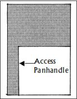
(Ord. 18-1008 § 1; Ord. 09-1012 § 1 (Exh. A))
14.16.006 Alteration, Subdivision
The process by which a recorded short subdivision, long subdivision or binding site plan may be modified. (Ord. 18-1008 § 1; Ord. 09-1012 § 1 (Exh. A))
14.16.010 Applicant
Any owner, or duly authorized agent of the owner, of a given lot or tract who applies for a subdivision or lot line adjustment under this title. (Ord. 18-1008 § 1; Ord. 09-1012 § 1 (Exh. A))
14.16.014 Application
All of the forms, surveys, maps, plans and accompanying documents required by this title for any particular short subdivision, long subdivision, binding site plan, or lot line adjustment. (Ord. 18-1008 § 1; Ord. 09-1012 § 1 (Exh. A))
14.16.016 Binding Site Plan
An alternative method for the division or redivision of land where the resulting lots, tracts, or parcels will be planned, managed and/or operated as parts of an integrated project, whether commercial, industrial, mobile home or condominium projects. (Ord. 18-1008 § 1; Ord. 09-1012 § 1 (Exh. A))
14.16.018 Block (Street)
A physically distinct land area comprising one (1) or more lots, parcels or tracts of land, and generally separated by streets, alleys or similar rights-of-way. (Ord. 18-1008 § 1; Ord. 09-1012 § 1 (Exh. A))
14.16.022 Block Length
The distance from one (1) corner of a given street block to another corner of the same. This distance shall be measured along the centerline of a given abutting street, alley or similar right-of-way between the points at which it intersects the centerlines of other abutting streets, alleys or rights-of-way. (Ord. 18-1008 § 1; Ord. 09-1012 § 1 (Exh. A))
14.16.026 Bond (Financial Instrument)
A surety bond, irrevocable letter of credit, cash deposit, escrow account, or assignment of funds required of a given applicant to ensure:
A. Satisfaction of any and all conditions placed on an approved project;
B. Performance of specified maintenance; or
C. Installation or warranty of any and all mandatory improvements. (Ord. 18-1008 § 1; Ord. 09-1012 § 1 (Exh. A))
14.16.028 Building Footprint
That area of a lot, exclusive of the following, where a structure can be constructed on the lot:
A. Access easements;
B. Utility easements;
C. Sensitive areas easements and buffers;
D. That area within the drip-line of any tree within a sensitive area easement; or
E. Required building setbacks pursuant to SMC 15.400.100 and 15.400.200. (Ord. 18-1008 § 1; Ord. 17-1018 § 1; Ord. 16-1022 § 1 (Exh. B); Ord. 16-1007 § 16; Ord. 09-1012 § 1 (Exh. A))
14.16.030 Buffer Strip
A linear land area designed and established to minimize the visual, noise and other environmental impacts a given land use may have on others. A buffer strip may include, but is not limited to, preserved natural vegetation, native and drought tolerant vegetation, evergreen trees, shrubs and tree plantings, vegetated LID BMPs, or landscape berms. (Ord. 18-1008 § 1; Ord. 16-1022 § 1 (Exh. B); Ord. 09-1012 § 1 (Exh. A))
14.16.040 Common Open Space
Any open space area, as defined in Chapter 15.105 SMC, available to all residents of the subject property that is appropriate for a variety of passive or active recreational activities. (Ord. 18-1008 § 1; Ord. 16-1022 § 1 (Exh. B); Ord. 09-1012 § 1 (Exh. A))
14.16.042 Comprehensive Plan
The officially adopted City of SeaTac Comprehensive Plan as referenced in Chapter 16A.25 SMC. (Ord. 18-1008 § 1; Ord. 09-1012 § 1 (Exh. A))
14.16.050 Cul-De-Sac
A short street having one (1) end open to an intersecting through street and the opposite end terminated by a circular turnaround, in accordance with Chapter 11.05 SMC. (Ord. 18-1008 § 1; Ord. 09-1012 § 1 (Exh. A))
14.16.054 Dedication
The deliberate appropriation of land by an owner for any general and public uses or purposes, reserving to him/herself no other rights than such as are compatible with the full exercise and enjoyment of the public uses to which the property has been devoted. (Ord. 18-1008 § 1; Ord. 09-1012 § 1 (Exh. A))
14.16.058 Density, Base Lot
A measure of the number of primary land uses present on all lands subject to a given land use application but not including any “sensitive areas” as defined by SMC 18.15.015, Definitions. As applied within this title, base lot density refers to a base or minimum land area required by the Zoning Code for every one (1) primary use, e.g., seven thousand two hundred (7,200) square feet per detached dwelling unit – six (6) units per acre – in the RL zone. (Ord. 24-1022 § 5 (Exh. C); Ord. 18-1008 § 1; Ord. 16-1007 § 17; Ord. 09-1012 § 1 (Exh. A))
14.16.066 Department
The Department of Community and Economic Development. (Ord. 18-1008 § 1; Ord. 11-1002 § 2; Ord. 09-1012 § 1 (Exh. A))
14.16.070 Development
An action making any physical alteration to land, or constructing any structure or assembly on land, for the purpose of increasing its suitability for direct human use. Development includes, but is not limited to, subdivision and the placement of survey monuments; clearing, filling, cutting, grading, drilling and dumping; the construction of roads, storm drainage systems, utilities and pedestrian facilities; the creation of parks and landscape installations; and the construction or alteration of residential, commercial and industrial structures and appurtenances. (See SMC 14.16.114, “Improvements.”) (Ord. 18-1008 § 1; Ord. 09-1012 § 1 (Exh. A))
14.16.082 Director
The Director of the Department of Community and Economic Development or his/her designee. (Ord. 18-1008 § 1; Ord. 11-1002 § 2; Ord. 09-1012 § 1 (Exh. A))
14.16.094 Easement
Land on which specific air, surface or subsurface rights have been conveyed for use by a person other than the owner, or to benefit some property other than the subject property. (Ord. 18-1008 § 1; Ord. 09-1012 § 1 (Exh. A))
14.16.098 Environmental Impact Statement (EIS)
A document prepared under the State Environmental Policy Act (Chapter 43.21C RCW) and/or its successor statutes to assess the environmental impacts of a given development proposal. (Ord. 18-1008 § 1; Ord. 09-1012 § 1 (Exh. A))
14.16.102 Floodplain
The total area subject to inundation by the base flood. (Ord. 18-1008 § 1; Ord. 09-1012 § 1 (Exh. A))
14.16.106 Hammerhead Turnaround
The area at the end of an access easement or closed road that provides intersecting space in which a vehicle may turn, back up, and then return to the primary street in accordance with the dimensional standards of Chapter 11.05 SMC. An emergency vehicle hammerhead turnaround constitutes a fire lane as defined in SMC 13.150.030. (Ord. 18-1008 § 1; Ord. 09-1012 § 1 (Exh. A))
14.16.110 Hearing Examiner
The City of SeaTac Hearing Examiner as established under Chapter 1.20 SMC to serve as the quasi-judicial reviewing authority for preliminary long subdivisions, preliminary binding site plans and other land use actions as set forth by ordinance. (Ord. 18-1008 § 1; Ord. 16-1007 § 18; Ord. 09-1012 § 1 (Exh. A))
14.16.114 Improvements
Any of a range of structures, assemblies or modifications to land required by the City as a condition for final plat or site plan approval. Such improvements generally include, but are not limited to, the construction or installation of survey monuments, streets, sidewalks, landscaping, streetlights, fire hydrants, storm water facilities, and utilities. (Ord. 18-1008 § 1; Ord. 09-1012 § 1 (Exh. A))
14.16.118 Land Surveyor, Professional
A person registered in accordance with Chapter 18.43 RCW and licensed to perform land surveys within the State of Washington. (Ord. 18-1008 § 1; Ord. 09-1012 § 1 (Exh. A))
14.16.122 Lot
A legal parcel of land for building purposes which shall have sufficient size to meet minimum requirements for use, coverage, and area, and to provide such yards and other open spaces as are herein required. Such lot shall have access to an improved public street, or to an approved private access. (Ord. 18-1008 § 1; Ord. 09-1012 § 1 (Exh. A))
14.16.124 Lot, Parent
Lot which is subdivided into unit lots through the unit lot subdivision process. (Ord. 24-1022 § 5 (Exh. C))
14.16.126 Lot, Separate
A physically separate and distinct parcel of property, established through:
A. Subdivision conducted according to all State statutes and local subdivision codes applicable at the time the lot, tract or parcel was created; or
B. Partition from a legally established parent lot by the dedication of public right-of-way or condemnation. (Ord. 18-1008 § 1; Ord. 09-1012 § 1 (Exh. A))
14.16.128 Lot, Unit
A subdivided lot, that allows up to one (1) dwelling unit, created from a parent lot and approved through the unit lot subdivision process. (Ord. 24-1022 § 5 (Exh. C))
14.16.130 Lot Area
The total horizontal area within the boundary lines of a lot, as defined under SMC 15.105.120, Lot Area. (Ord. 18-1008 § 1; Ord. 16-1007 § 19; Ord. 09-1012 § 1 (Exh. A))
14.16.138 Lot Line Adjustment
Any relocation of one (1) or more lot boundary lines of two (2) or more lots where such action does not result in the creation of additional lots, or the creation of any substandard lot as defined by SMC 15.105.120, Lot, Substandard. (Ord. 18-1008 § 1; Ord. 16-1007 § 20; Ord. 09-1012 § 1 (Exh. A))
14.16.142 Lot of Record
A lot recorded with King County and appearing on official County Assessor maps. (Ord. 18-1008 § 1; Ord. 09-1012 § 1 (Exh. A))
14.16.143 Low Impact Development (LID) Best Management Practices (BMP)
Distributed stormwater management practices, integrated into a project design, that emphasize natural hydrologic processes of infiltration, filtration, storage, evaporation and transpiration while protecting against off-site flooding and soil instability. LID BMPs include, but are not limited to, bioretention, permeable pavement, cast in place pavers, limited infiltration systems, roof downspout controls, dispersion, soil amendments, and minimal excavation foundations. (Ord. 18-1008 § 1; Ord. 16-1022 § 1 (Exh. B))
14.16.144 Material Error
Errors in the information provided with the application or the oversight or misuse of facts that existed at the time the application was prepared. (Ord. 18-1008 § 1; Ord. 09-1012 § 1 (Exh. A))
14.16.150 Modification, Substantial
A threshold for changes that terminate previous approval of an unrecorded subdivision and compel the applicant to file a new action. Substantial modifications generally include changes to the dimensions of an approved proposed lot, tract or parcel in excess of ten percent (10%) of those originally proposed. (Ord. 18-1008 § 1; Ord. 09-1012 § 1 (Exh. A))
14.16.154 Monument
A permanent marker or post installed pursuant to RCW 58.17.240. (Ord. 18-1008 § 1; Ord. 09-1012 § 1 (Exh. A))
14.16.156 Open Space
A variety of lands which are created and preserved for open space purposes, including:
A. Natural areas with outstanding scenic or recreational (active or passive) value;
B. Public access areas to creeks, rivers, lakes or Puget Sound;
C. Lands that create corridors between natural features;
D. Areas defined as critical areas under the critical areas ordinance;
E. Any landscaped area that exceeds the minimum adopted landscape requirements;
F. Active outdoor recreation areas;
G. Multi-purpose green spaces;
H. LID BMPs, including rain gardens, bioretention, vegetated roofs with roof access, and dispersion; and/or
I. Pedestrian and bicycle-only corridors separate from the public or private roadway system and dedicated to passive recreation, including access links in sensitive area buffers. The square footage (length times width) of pedestrian and bicycle-only corridor shall be counted as usable open space. (Ord. 18-1008 § 1; Ord. 16-1022 § 1 (Exh. B))
14.16.158 Ordinary High Water Mark
The definition of ordinary high water mark shall be the same as defined in Chapter 18.05 SMC. (Ord. 19-1015 § 7; Ord. 18-1008 § 1; Ord. 09-1012 § 1 (Exh. A))
14.16.162 Owner
A person, as defined by SMC 1.01.050, who is the fee owner of, or otherwise retains a controlling interest in, a given property. (Ord. 18-1008 § 1; Ord. 09-1012 § 1 (Exh. A))
14.16.170 Plat, Preliminary
A neat and scaled map or similar drawing of a proposed subdivision or lot line adjustment that portrays the general layout of lots, blocks, topography, streets and alleys, utility lines, fire hydrants and other elements prescribed by this title and City application forms. (Ord. 18-1008 § 1; Ord. 09-1012 § 1 (Exh. A))
14.16.174 Plat, Final
An accurate technical survey and representation of a subdivision or lot line adjustment that portrays the final layout of streets, lots, blocks, ingress/egress easements, utility easements, public dedications, building envelopes and any other elements required as conditions of approval in a form satisfactory for recording with King County. (Ord. 18-1008 § 1; Ord. 09-1012 § 1 (Exh. A))
14.16.178 Responsible Official
The Departments of Community and Economic Development, Parks and Recreation, Police Services, Fire Services and the Hearing Examiner where applicable. (Ord. 24-1022 § 5 (Exh. C); Ord. 18-1008 § 1; Ord. 09-1012 § 1 (Exh. A))
14.16.180 Reviewing Authority
The Departments of Community and Economic Development, Parks and Recreation, Police Services, Fire Services and the Hearing Examiner where applicable. (Ord. 18-1008 § 1; Ord. 11-1002 § 2; Ord. 09-1012 § 1 (Exh. A))
14.16.182 Road or Street, Public
All publicly owned streets, highways, freeways, avenues, alleys, courts, places, or other public ways in the City, whether improved or unimproved, held in public ownership and intended to be open as a matter of right to public vehicular and pedestrian access. (Ord. 18-1008 § 1; Ord. 09-1012 § 1 (Exh. A))
14.16.186 Road or Street, Private
Any improved easement or tract or street for vehicular and pedestrian ingress and egress which is not a public street but as to which individual abutting property owners retain responsibility for construction and maintenance. Driveways shall not be considered private roads or streets where they serve only one (1) residence. Private roads or streets may constitute fire lanes in accordance with SMC 13.150.030. (Ord. 18-1008 § 1; Ord. 09-1012 § 1 (Exh. A))
14.16.194 Setback
The definition of setback shall be the same as defined in SMC 15.105.190. (Ord. 18-1008 § 1; Ord. 09-1012 § 1 (Exh. A))
14.16.196 Short Plat
The map or representation of a short subdivision prepared by a Washington State licensed professional surveyor in accordance with this title. (Ord. 18-1008 § 1; Ord. 09-1012 § 1 (Exh. A))
14.16.202 Site Plan, Graphic
A preliminary or final survey or representation of lands subject to a binding site plan, which portrays:
A. All items of information otherwise required of a subdivision plat.
B. The location of all existing and proposed uses, improvements, open spaces, landscaping, environmentally sensitive areas and any other elements required by this title and other provisions of the SeaTac Municipal Code.
C. Limitations and conditions on the future use of all depicted lots and tracts.
D. Provisions to ensure conformity of the development and improvements with the approved site plan. (Ord. 18-1008 § 1; Ord. 09-1012 § 1 (Exh. A))
14.16.218 Subdivision
Any delineation and legal segregation of real property into lots, tracts, parcels, or sites for the purpose of development, sale, lease, or transfer of ownership through the process for long subdivision, short subdivision, unit lot subdivision, or binding site plan. (Ord. 24-1022 § 5 (Exh. C); Ord. 18-1008 § 1; Ord. 09-1012 § 1 (Exh. A))
14.16.222 Subdivision, Long
A division or redivision of land into ten (10) or more lots, tracts, parcels, or sites for the purpose of development, sale, lease, or transfer of ownership. (Ord. 18-1008 § 1; Ord. 09-1012 § 1 (Exh. A))
14.16.226 Subdivision, Short
A division or redivision of land into nine (9) or fewer lots, tracts, parcels, or sites for the purpose of development, sale, lease, or transfer of ownership. (Ord. 18-1008 § 1; Ord. 15-1012 § 3; Ord. 09-1012 § 1 (Exh. A))
14.16.230 Tract
A physically separate piece of real property reserved for access, open space, conservation, drainage or another specialized purpose, and not considered a buildable lot or site for residential, commercial or industrial construction. (Ord. 18-1008 § 1; Ord. 09-1012 § 1 (Exh. A))
14.16.231 Unit Lot Subdivision
The division of a parent lot into two (2) or more unit lots within a development and approved through the unit lot subdivision process. (Ord. 24-1022 § 5 (Exh. C))
14.16.232 Vegetated LID BMPs
LID BMPs that utilize landscaping. (Ord. 18-1008 § 1; Ord. 16-1022 § 1 (Exh. B))
14.16.234 Zoning Code
SMC Title 15, as constituted and thereafter amended. (Ord. 18-1008 § 1; Ord. 09-1012 § 1 (Exh. A))